Australia, North America, Eurasia, Antarctica, Africa. B) Europe, Asia, South America, Australia, Antarctica. 2. The first circumnavigation of the world was made by: A) F. Magellan, B) Przhevalsky F.F.
3. The coasts of Africa are washed by the seas: A) the Arctic Ocean B) the Arctic, Atlantic, Pacific, Indian oceans C) the Atlantic, Indian, Southern 4. The highest mountain system of South America is: A) the Andes, B) the Himalayas, Pamirs, Tibet B) Rocky Mountains, Coast Range 5. The largest rivers in Africa: A) Missouri, Mackenzie, Yukon. B) Nile, Congo, Niger. B) Volga, Amur, Syr Darya. 6. States of South America: A) Brazil, Argentina, Chile B).USA, Canada, Mexico. B) China, Russia, Kazakhstan. 7. Mountains of North America: A) Andes B) Appalachians
8. Extreme points of Africa: A) Almadi, Ben Seka, Agulhas, Ras Hafun B) York, South-East, South-West, Byron C) Roca, Chelyuskin, Piay, Dezhneva 9. Which ocean is the warmest in terms of surface temperature water? 1) Indian 2) Pacific 3) Atlantic 4) Arctic. 10. Which statement about the United States is false? A) In the east of the country are the Appalachian Mountains. B) The capital of the USA is Washington. C) The westernmost point of North America is located on the territory of the United States - Cape Prince of Wales. D) The United States ranks third in the world in terms of territory size. 11. Which statement is wrong? A) China is the most populous country in the world. B) The coastal part of China is characterized by a monsoon climate. C) The Yangtze River, which flows through China, is the longest river in Eurasia. D) The largest areas in China are occupied by the natural zone of steppes and forest-steppes. 12. Which of the following cities is the capital of Australia? A) Melbourne B) Sydney
II. In tasks 13 – 15, establish a correspondence between the country and its capital. 13. Country
1. Poland
2. Estonia
3. Switzerland
14. Country
1. Georgia
2. Saudi Arabia
3. Mongolia
15. Country
1. Canada
2. Brazil
3. Argentina
III. In tasks 16 – 17, identify the state based on its brief description
16. The state is located in Western Europe. The capital is located on one of the major rivers. The official language is widespread throughout the world due to the colonial past of this state. The symbol of the state capital is a tower built for the World Trade Exhibition.
17. The state is located on the continent of Africa and occupies a coastal position. The territory of the state is washed by the seas that make up two oceans. The seas are connected by a shipping canal.
a) southern latitude and eastern longitude;
b) northern latitude and eastern longitude;
c) northern latitude and western longitude.
2)The extreme northern point of Russia is the cape:
a) Chelyuskin;
b) Outbuildings;
c) Dezhnev.
3) The easternmost point of Russia has a longitude:
a) western;
b) eastern;
c) northern.
4) Russia’s maritime borders, compared to land borders, have the following length:
a) big;
b) equal;
c) less.
5) The presence of three climatic zones on the territory of Russia is explained by the large extent of the country:
a) from north to south;
b) from west to east.
6) The seas of the Arctic Ocean compared to the seas of the Pacific Ocean:
a) deeper;
b) the same in depth;
c) less deep.
7)The terminal ports of the Northern Sea Route are:
a) Murmansk and St. Petersburg;
b) St. Petersburg and Vladivostok;
c) Vladivostok and Murmansk,
8) Time within the same time zone is called:
a) local;
b) waist;
c) maternity leave.
9) The boundaries of time zones are drawn in accordance with: a) parallels;
b) meridians;
c) horizontal.
10) In Russia, the last people to celebrate the New Year are:
a) Anadyr;
b) Magadan;
c) Kaliningrad.
11) There are no points on the territory of Russia that have:
a) northern latitude;
b) southern latitude;
c) western longitude.
12)The extreme eastern point of Russia is:
a) Cape Dezhnev;
b) Ratmanov Island;
c) Cape Chelyuskin.
13) The land borders of Russia compared to the sea borders have the following length:
a) big;
b) the same;
c) less.
14) The presence of climatic regions within climatic zones is explained by the large extent of Russia in the direction:
a) from north to south;
b) from west to east.
15) Salinity of the seas of the Pacific Ocean, compared to the seas of the Arctic Ocean:
a) higher;
b) the same;
c) below.
16) The time of this meridian is called:
a) local;
b) waist;
c) maternity leave.
17) A new day in Russia begins with the time zone:
a) second;
b) eleventh;
c) first.
18) The local time of a point depends on its:
a) geographic latitude;
b) geographic longitude.
19) The Northern Sea Route passes through the seas:
a) Atlantic and Pacific oceans;
b) the Pacific and Arctic oceans;
c) the Arctic and Atlantic oceans.
20) The territory of Russia is washed by as many oceans as the territory:
a) Brazil;
b) Canada;
in Australia.
21. The area of Russia is:
a) 17.1 million km2;
b) 22.4 million km2;
c) 17.8 million km2.
22. Northernmost continental point:
a) Cape Dezhnev;
b) Cape Fligeli;
c) Cape Chelyuskin. 23. Latitude of the extreme eastern point:
a) 170° W. d.;
b) 170° E. d.
24. Russia intersects:
a) with the equator;
b) with the northern tropic;
c) with the Arctic Circle.
25. The longest border between Russia and the state: a) Mongolia;
b) China;
c) Kazakhstan;
d) Ukraine.
26. Which rivers do the Russian border run along:
a) along the Amur;
b) along the Terek;
c) according to Ussuri;
d) along the Kura.
27. With which country does Russia’s border begin on the shores of the Barents Sea:
a) with Finland;
b) with Norway;
c) with Estonia.
28. What part of the territory of Russia is located behind S.P.K.?
a) 1/5 (20%);
b) 1/2 (50%); c) 1/4 (25%).
29. With which countries does Russia only have a maritime border?
a) USA; b) China;
c) Japan; d) Norway.
30. Russia is located:
a) in the northern and western hemispheres;
b) in the northern and eastern hemispheres;
c) in the northern, eastern and western hemispheres;
d) only in the northern hemisphere.
31. The seas washing Russia do not freeze:
a) Chernoe and Kara;
b) Barents and Chernoe;
c) Okhotsk and Japanese.
32. The easternmost point of Russia is located:
a) in the Western Hemisphere;
b) in the eastern hemisphere.
33. The northernmost point of Russia is located:
a) in the Severnaya Zemlya archipelago;
b) in the Spitsbergen archipelago; c) in the Franz Josef Land archipelago.
34. Find a match:
Extreme points of Russia:
a) northern; 1) m. Dezhneva;
b) southern; 2) m. Chelyuskin;
c) western; 3) the city of Bazarzyuzu;
d) eastern; 4) sand spit (Curonian) west of Kaliningrad.
35. Russia has only a maritime border with the states:
a) Norway and Japan;
b) Japan and China;
c) Japan and the USA.
36. In the north, Russia is washed by the seas:
a) Beloe, Barentsevo, Kara;
b) Beringovo, Kara, Laptev;
c) Baltic, Black, White.
37. The largest and deepest sea off the coast of Russia
a) Okhotsk;
b) Barentsevo;
c) Beringovo;
d) Japanese.
38. The shallowest sea on Earth and the smallest sea in Russia
a) Azovskoe;
b) Aral;
c) White;
d) Baltic
a) the continent ranks last in terms of territory among other continents
b) the continent is washed by the waters of two oceans of the Earth
c) the continent has a land connection with Eurasia
d) the island of Tierra del Fuego is located near the shores of the mainland
e) the continent was discovered by Christopher Columbus
f) the main population of the mainland consists of descendants of English settlers
g) the entire continent is occupied by one state
No. 2 Establish a correspondence between a body of water and the part of the continent that it washes.
WATER BODY PART OF THE CONTINENT
1) Pacific Ocean a) northern
2) Indian Ocean b) southern
3) Gulf of Carpentaria c) eastern
4) Great Australian Bight d) western
| Parameter name | Meaning |
| Article topic: | EURASIA |
| Rubric (thematic category) | Geography |
Eurasia is the largest continent on Earth. Taking into account the islands, it is located in all hemispheres of the planet, although it mainly belongs to the northern and eastern. Its coastline is very indented, the mainland is washed by a huge number of seas and bays, and many large and small peninsulas jut into the ocean. The natural and climatic conditions of Eurasia are extremely diverse: while its southern territories are located in the equatorial zone of the planet, the northern ones go far beyond the Polar Circle.
Extreme points of Eurasia:
Northern: Cape Chelyuskin – 77°43’N. 104°18’E
South: Cape Piai – 1°16’N. 103°31’E
Western: Cape Roca – 38°47’N. 9°30’W
Eastern: Cape Dezhnev – 66°5’N. 169°39’W
The continent is located in all climatic zones of the Earth: equatorial, subequatorial, tropical, subtropical, temperate, subarctic and arctic.
Eurasia is washed by all the oceans of the Earth, with the exception of the Southern: Atlantic from the west, Arctic from the north, Pacific from the east and Indian from the south.
Eurasia is connected to Africa in the southwest through the Sinai Peninsula, and in the east it is separated from North America by the narrow Bering Strait.
Eurasia is washed by the waters of all four oceans, which form marginal and inland seas along its shores: the Baltic, Black, Azov, Mediterranean, North and Norwegian seas; The Straits of Gibraltar and the English Channel, as well as the Bay of Biscay, belong to the Atlantic Ocean. There are large islands here: Great Britain, Iceland, Ireland, as well as peninsulas: Scandinavian, Iberian, Apennine. The northern shores of Eurasia are washed by the seas of the Arctic Ocean: Barents, Kara, Laptev, East Siberian, Chukotka. The largest islands are Novaya Zemlya, Spitsbergen; peninsulas - Taimyr, Yamal. The Bering Strait connects the Arctic Ocean with the Pacific Ocean, which forms the marginal seas off the coast of Eurasia: Bering Sea, Okhotsk Sea, Japan Sea, Yellow Sea, East China Sea, South China Sea. The largest islands: Sakhalin, Hokkaido, Honshu, Philippine, Greater Sunda; peninsulas: Kamchatka, Korea, Indochina.
The seas of the Indian Ocean (Red, Arabian) and bays (Persian, Bengal) extend deep into the land. They are washed by large peninsulas - Arabian, Hindustan, Malacca.
Eurasia is a continent of contrasts. Due to the enormous size of the continent, the nature of Eurasia is diverse and complex. Here is the greatest peak of the world - Mount Chomolungma (Everest) with a height of 8848 m and the deepest depression of land (relative to sea level) - the Dead Sea (-402 m); the cold pole of the Northern Hemisphere in Oymyakon, where a temperature of -70° is recorded, and the sultry regions of Mesopotamia; the arid regions of the Arabian Peninsula, where only 44 mm of precipitation falls per year, and the humid regions of North-East India (Cherrapunji) with precipitation of 12,000 mm or more per year; in the north of the continent there are arctic deserts, and in the south there are humid equatorial forests.
From the history of research. Long before the era of the Great Geographical Discoveries and the founding of the First Geographical Institute by the Portuguese Prince Henry, the inhabitants of Europe were actively exploring the lands around them and making geographical discoveries. One of the first were the Phoenicians, who in the 2nd century BC. e. explored the shores of the Mediterranean Sea, then the ancient Greeks completed the discovery of Southern Europe. And during the reign of the Romans, who conquered the southern coast of the Mediterranean Sea, the name of the third part of the world appeared - Africa. During the Age of Great Geographical Discovery, the famous journey of the Portuguese navigator Vasco da Gama to India took place, as well as the circumnavigation of Ferdinand Magellan, who, having sailed across the Pacific Ocean, approached the islands of Indonesia. The nature of Central Asia, Siberia and the Far East has long remained a mystery to European geographers.
The famous expeditions of our compatriots - Semyon Dezhnev to Siberia and the Far East, Vladimir Atlasov to Kamchatka, Pyotr Chikhachev to Altai, Pyotr Semyonov-Tien-Shansky to the Tien Shan mountains, Nikolai Przhevalsky to Central Asia - filled the gaps on the geographical maps of Asia.
Relief and minerals. The diversity of the relief of Eurasia is explained by the structural features of the earth's crust in different parts of the continent. The ancient platforms: East European, Siberian, Sino-Korean, Indian, African-Arabian correspond to vast stable plains: East European Plain, Central Siberian Plateau, Great Chinese Plain, Deccan Plateau, Arabian Plateau. The areas of new folding correspond to mountain belts: Alpine-Himalayan, including the Pyrenees, Apennines, Alps, Carpathians, Caucasus, Pamir, Himalayas; as well as the Pacific belt of folded mountains (part of the Pacific “Ring of Fire”), stretching along the eastern shores of Eurasia from Kamchatka to the Malay Archipelago. Here, in the Pacific Ocean, there are deep-sea trenches. These are seismically active areas with frequent earthquakes and volcanic eruptions, the most famous of which are: Vesuvius (Apennine Peninsula), Etna (Sicily), Hecla (Iceland). The highest active volcano in Eurasia is Klyuchevskaya Sopka (4750 m) on the Kamchatka Peninsula, Fuji (Honshu Island), Krakatoa, located on a small island in the Malay Archipelago.
Mountains The Urals, Altai, Tien Shan appeared in the era of ancient folding. At the same time, Altai and Tien Shan underwent new uplifts - rejuvenation of the relief, in contrast to the Ural Mountains, which were greatly destroyed and smoothed.
In the vicinity of the folded mountains in the foothill troughs, a layer of the earth's crust formed lowlands, for example, the Indo-Gangetic (Hindustan Peninsula) and Mesopotamian (Arabian Peninsula).
Minerals Eurasia is extremely diverse, and its reserves are large. Iron ore deposits in the north of the Scandinavian Peninsula, on the Hindustan Peninsula and northeast China are associated with igneous rocks. A strip of deposits of such rare metals as tungsten and tin stretches across southern China, the Indochina and Malacca peninsulas, forming the so-called tin-tungsten belt. The mountains of the Alpine-Himalayan belt and the Deccan plateau abound in ores of non-ferrous metals.
Oil and gas The West Siberian Lowland, the coast of the Persian Gulf, the North Sea shelf, the Arabian Peninsula and the Mesopotamian Lowland are exceptionally rich. Coal deposits are also associated with sedimentary rocks, the largest of which are located in the Ruhr and Upper Silesian basins in Western Europe, in the Donets basin in southern Russia, as well as on the Great Chinese Plain and the Indo-Gangetic Lowland.
Place of Birth iron ore associated with metamorphic rocks, such as, for example, the Kursk magnetic anomaly in Russia, as well as with sedimentary rocks (the Lorraine deposit in Western Europe). Bauxite is of sedimentary origin. Their deposits are located along the Alps, south of the Carpathians and on the Indochina Peninsula.
Eurasia is the only continent of the Earth that is located in all climatic zones and in all natural zones (Fig. 26). Its nature is extremely diverse; therefore, several large natural complexes are distinguished on its territory: Northern, Western, Central and Southern Europe; South-West, Central, East and South Asia. The patterns of development of the population and political map are also very different; therefore, we will consider them separately for Europe and Asia.
EURASIA - concept and types. Classification and features of the category "EURASIA" 2017, 2018.
NORTH AMERICA West Antarctica, East Antarctica. ANTARCTICA Great Barrier Reef. AUSTRALIA Capes (specify coordinates): Steep Point, South Point, York, Byron. Oceans: Indian, Pacific Seas: Timorese, Arafura,... .
North America. South America. Australia. Africa. Seas - Mediterranean, Red. Gulfs – Aden, Guinea. Straits – Gibraltar, Bab el-Mandeb, Mozambique. Peninsula of Somalia. IslandMadagascar. Rivers - Nile, Congo, Orange,... .
North America. South America. Australia. Seas - Tasmanovo, Coral. Gulfs – Great Australian, Carpentaria. Straits – Torres, Bassov. Islands - New Guinea, New Zealand, Tasmania. Peninsulas – Arnhem Land, Cape York. Rivers – Moray,...
2 prove that Antarctica is the coldest continent on earth (examples)
3 why is Antarctica called the continent of the hard sun?
4 people in Antarctica. Why study Antarctica
5 oases exist in Africa and Antarctica (examples) striking features and differences.
(if you don’t know, don’t do it from the Internet, it’s advisable not to take it)
Thank you in advance.
Australia, North America, Eurasia, Antarctica, Africa. B) Europe, Asia, South America, Australia, Antarctica. 2. The first circumnavigation of the world was made by: A) F. Magellan, B) Przhevalsky F.F.
3. The coasts of Africa are washed by the seas: A) the Arctic Ocean B) the Arctic, Atlantic, Pacific, Indian oceans C) the Atlantic, Indian, Southern 4. The highest mountain system of South America is: A) the Andes, B) the Himalayas, Pamirs, Tibet B) Rocky Mountains, Coast Range 5. The largest rivers in Africa: A) Missouri, Mackenzie, Yukon. B) Nile, Congo, Niger. B) Volga, Amur, Syr Darya. 6. States of South America: A) Brazil, Argentina, Chile B).USA, Canada, Mexico. B) China, Russia, Kazakhstan. 7. Mountains of North America: A) Andes B) Appalachians
8. Extreme points of Africa: A) Almadi, Ben Seka, Agulhas, Ras Hafun B) York, South-East, South-West, Byron C) Roca, Chelyuskin, Piay, Dezhneva 9. Which ocean is the warmest in terms of surface temperature water? 1) Indian 2) Pacific 3) Atlantic 4) Arctic. 10. Which statement about the United States is false? A) In the east of the country are the Appalachian Mountains. B) The capital of the USA is Washington. C) The westernmost point of North America is located on the territory of the United States - Cape Prince of Wales. D) The United States ranks third in the world in terms of territory size. 11. Which statement is wrong? A) China is the most populous country in the world. B) The coastal part of China is characterized by a monsoon climate. C) The Yangtze River, which flows through China, is the longest river in Eurasia. D) The largest areas in China are occupied by the natural zone of steppes and forest-steppes. 12. Which of the following cities is the capital of Australia? A) Melbourne B) Sydney
II. In tasks 13 – 15, establish a correspondence between the country and its capital. 13. Country
1. Poland
2. Estonia
3. Switzerland
14. Country
1. Georgia
2. Saudi Arabia
3. Mongolia
15. Country
1. Canada
2. Brazil
3. Argentina
III. In tasks 16 – 17, identify the state based on its brief description
16. The state is located in Western Europe. The capital is located on one of the major rivers. The official language is widespread throughout the world due to the colonial past of this state. The symbol of the state capital is a tower built for the World Trade Exhibition.
17. The state is located on the continent of Africa and occupies a coastal position. The territory of the state is washed by the seas that make up two oceans. The seas are connected by a shipping canal.
It is considered the second largest in the world. It is washed by two oceans and several seas at once; on its territory, which consists of 29.2 million square kilometers, there are 55 states. The population of this continent is below the poverty line, with the exception of some countries. Africa is such that it is located in both the northern and southern hemispheres. Thanks to this, the climate here is very diverse.
Extreme points of landmass of the mainland
We will begin our description of the geographical position of Africa with the capes, which are its extreme points relative to the cardinal points. So, the eastern point is Cape Blanco (also called Ras Engela, Ben Sekka or El Abyad). It is located in Tunisia, on the Mediterranean coast. Many vacationers who visit this particular country often come to this famous place. The southernmost point in Africa is Cape Agulhas, which is also sometimes called Agulhas. It is located in South Africa, not far from the famous Western terminus on the continent is Cape Almadi. It is located in Senegal, on the Cape Verde Peninsula, and is washed by the Atlantic Ocean. Well, Cape Ras Hafun is considered the extreme eastern point of the mainland. It is located in Somalia, its length is 40 kilometers, and it is inhabited mainly by local tribes.
Seas and oceans
Now consider the geographical position of Africa in relation to the waters of the world's oceans. Since the coastline of the mainland is not particularly indented by bays, there are few bays here, as well as seas. So, the eastern coast of the continent is washed by the Indian Ocean. It is adjacent to the Gulf of Aden, which is located between Africa and the Red Sea, which also separates these lands, but a little further north, and the Mozambique Strait - the longest strait in the world, which is located between the continent and the island of Madagascar.

The western shores of Africa are washed by the Atlantic. It includes only the Gulf of Guinea, which touches the coasts of several states at once. Considering the geographical position of Africa relative to the Atlantic Ocean, many also note that the Mediterranean Sea, which touches the northern shores, is a bay of this large body of water. In the south of the continent there are no bays, no straits, no seas. Here two oceans connect.
Inland waters
The internal hydrosphere on the continent is not too thick, but it is fundamentally different from any other and is considered unique and inimitable. We also note that the characteristics of the geographical location of Africa give us the opportunity to understand that this continent is the driest in the world, and therefore all the reservoirs that are located on it are gradually drying up. So, one of the longest rivers in the world flows here - the Nile (length - 6852 km). Other major rivers here are the Niger, Congo, Zambezi, as well as the Limpopo and Orange River in the south of the mainland.

Victoria is considered the largest lake in Africa - the deepest point reaches 80 meters. It is followed by lakes Nyasa and Tanganyika, which are located in places where lithospheric plates are broken, as well as Lake Chad, which dries out very quickly.
Useful deposits
Relief and surface
The physical and geographical position of Africa is due to its predominantly flat terrain. The northwest of the continent is occupied by the Cape and Drakensberg Mountains in the south. Tanzania is home to the East African Plateau, which is home to the Kilimanjaro volcano, the highest point on the continent, which reaches 5895 meters in height. The northern part of Africa is the Sahara Desert, in which there are two highlands (Tibesti and Ahaggar). But the lowest point of the continent is the depression in Lake Assal - 157 meters below sea level.
Climatic conditions
The geographical location of the continent of Africa causes it to have a very dry and hot climate. It is literally intersected by the equator line, from which cooler, but at the same time drier climatic zones diverge to the north and south. So, along the equator there is an area of especially high temperatures that do not change throughout the year. There is also a large amount of rainfall here. The hottest point in Africa is Dallol. To the north and south of the equator there are subequatorial zones. There is heavy rainfall throughout the summer, and in winter the monsoons arrive here, bringing drought.

Then follow two tropical stripes. In the north, in this zone there is the Sahara Desert, and in the south - the Namib and Kalahari. It is clear that these natural sites are characterized by minimal precipitation and strong winds.
Features of the geographical location of Africa
The configuration of the continent should be noted in order to determine its main features. The bottom line is that its northern part has a width of over 7.5 thousand km, while the southern part stretches only 3000 km. For this reason, the zoning of landscapes in relation to the poles from the equator is uneven. Let us also pay attention to the geographical position of Africa relative to the bays and straits. Many of them form islands that, according to geological characteristics, belong to this continent. Among them are Madagascar, Zanzibar, the Canary Archipelago and many others. They belong to countries such as Tunisia, Zambezi, Kenya, South Africa, and Somalia. Many archipelagos are completely invisible due to their small size, and therefore are not even shown on maps.
A continent is a huge piece of land surrounded on all sides by water. Continents consist of continental crust, in everyday language called earth. It was not immediately known how many continents there are on Earth. Now we have settled on the number six. These are Africa, Eurasia, South America, North America, Antarctica, Australia. Continents occupy the Earth evenly, there are no pronounced voids. The total area of the continents is slightly less than a third of the entire surface of the Earth. Islands located close to one or another continent are also considered continents.
Eurasia, South and North America
The largest and heaviest continent on earth is Eurasia. Eurasia is located on three hemispheres at once - Southern, Western and Eastern. Europe reaches the Western Hemisphere only at its extremities from the east and west, and the most significant territory belongs to the Eastern Hemisphere.
From north to south, Eurasia extends for eight thousand kilometers; from west to east, the distance becomes twice as large and amounts to sixteen thousand kilometers. The area of Eurasia is more than 50,000,000 square kilometers. This means that the continent occupies a third of the non-aquatic territory of the Earth. A map of planet Earth shows that there are as many as four oceans off the coast of Eurasia:
- Arctic from the north;
- Indian from the south;
- Quiet from the east;
- Atlantic from the west.
The islands belonging to Eurasia are represented by a fairly large number and occupy an area of about 2.75 million sq. km. That’s why Eurasia is called that, because it will unite two parts of the world - Europe and Asia. The border between them is considered (very arbitrarily) to be the Ural Mountains. In the north, Eurasia becomes part of the Arctic. The westernmost point of the continent is Cape Roca, the easternmost point is Cape Dezhnev.
South America also occupies more than one hemisphere, but is predominantly located in the South and West, while only a small piece of the continent extends into the North. It borders on two oceans - the Pacific in the south and the Atlantic in the east. On the northern side, the Caribbean Sea and the Isthmus of Panama separate South America from North America. There are several islands adjacent to South America. As the notes of the traveler http://notetravel.ru assure, the named continent is the most “watery”.
The river massifs of the Amazon, Parana, Orinoco, the huge Lake Tititaka, accessible for navigation, and countless other lakes - all of this forms the richest water resources. South America also boasts the most powerful waterfalls in the world - the famous Angel and Iguazu.

North America belongs to only one hemisphere - the Western. As already mentioned, the border with South America is the Isthmus of Panama. The Bering Strait is located between Eurasia and North America. Oceans and seas wash the shores of North America. Approximately a fifth of the mainland's area is made up of the territories of the adjacent islands. Among them:
- Aleutian;
- Vancouver;
- Greenland, etc.
Africa, Australia and Antarctica
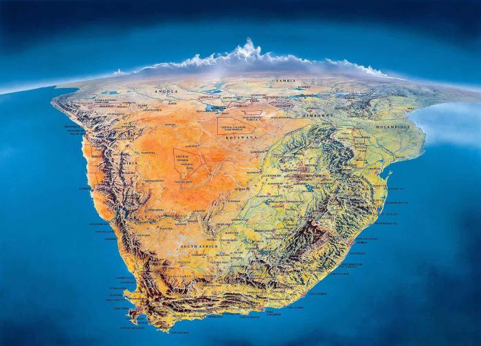
Africa is the second largest world continent after Eurasia, as can be seen on the map of planet Earth. In the north, Africa meets the waters of the Mediterranean Sea, in the northeast - the Red Sea. The east and south are bordered by the Indian Ocean, and the west by the Atlantic. This is a unique land, stretching from the northern subtropics to the southern ones. Africa is crossed by the equator and several climate zones.
Africa is the driest continent on Earth. There is little precipitation here, and there are no reserves of glacial water. Therefore, the continent needs artificial irrigation. The coastal part of Africa with natural access to water is the most favorable for life. If you want to settle in Africa, then choose its shores for yourself.
Australia is also a very arid continent with deserts in the central part. It is the smallest continent on Earth in the Southern and Eastern Hemispheres of the Earth. It is located adjacent to the Indian and Pacific oceans. It occupies only 7.6 million sq. km. The islands of Tasmania and New Guinea are considered to belong to this continent.
The continent of Antarctica was discovered later than all other continents; this happened around the first half of the nineteenth century.
“So how many continents are there on Earth? Before the discovery of Antarctica, the answer was “five.”
This is the coldest place on the planet, so there are almost no people here, except for scientific research expeditions. The continent is located at the very edge of the South Pole and is surrounded on all sides by the Southern Ocean. The area of Antarctica is twice the size of Australia. The entire surface of the continent is covered with ice and snow, so Antarctica is the keeper and supplier of fresh water.