Sakhalin is an elongated island located in the Pacific Ocean. In Russian Far East(between 45°50' and 54°24'N latitude). Together with the Kuril Islands, it forms the Sakhalin region, the capital of which is Yuzhno-Sakhalinsk.
The island has a length from north to south of 948 km, with an average width of several tens of kilometers. The island's area is 76,400 square kilometers, making it the 23rd largest island in the world.

Sakhalin Island is within walking distance of the Asian continent, from which it is separated by the Strait of Tartary; in the northern part, the distance to the continent narrows to approximately 7 km. In the south, the La Perouse Strait separates it from Japanese Hokkaido. The northern point of the island is Cape Elizabeth, and Cape Crillon is the southernmost point.
The island's territory is mostly mountainous, with the exception of the northern part, where the northern lowlands begin. The central and southern mountains are mainly elongated in the meridional direction, the largest of which are the Western chain. In the Eastern chain, Mount Lopatina (1609 m) is the highest point of the island. There are no large rivers on the island.
Climate

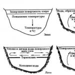
The temperature on Sakhalin Island is quite low for its latitude; this is caused by cold sea currents that carry cold to the shores of Sakhalin; the western shores of Sakhalin are the most exposed to the cold.
The island has very cold winters, with January temperatures ranging between -18°C and -25°C in the north and between -6°C and -12°C in the south. Temperatures rise very slowly due to the proximity of cold seas, so spring comes late, about three weeks later than on the mainland. The hottest month of the year is generally August, with average temperatures between 11°C and 16°C in the north and between 16°C and 20°C in the south.
Population

At the beginning of the 20th century, about 32,000 Russians (of whom 22,150 were deported) lived on the island along with several thousand natives. Currently, Sakhalin has 673,000 inhabitants, of which 83% are Russian. 400,000 Japanese who lived in the southern part of the island were forced to take refuge in Japan after World War II. The capital, Yuzhno-Sakhalinsk, which has nearly 200,000 residents, is home to a small number of Koreans who were brought here during World War II to work in the coal mines.
Popular science film about nature. Sakhalin, ecology and life of indigenous peoples
Even after the Crimean project, the bridge to Sakhalin is surprising: it will be built in the middle of “nothing,” says a federal official. In addition to the crossing in the area of the Nevelskoy Strait, which is only 7 km long (the narrowest isthmus in the Tatar Strait), it is necessary to build access roads to Komsomolsk-on-Amur and the Nysh station on Sakhalin, Transport Minister Maxim Sokolov explained to TASS: a total of 500 km of railway .
Sokolov estimated the construction of a bridge with access roads at 500 billion rubles. in 2013 prices. This is approximately 615 billion rubles. in prices of the second quarter of 2017, calculated PwC partner Dmitry Kovalev. Initially, the amount was lower: in June, Putin estimated the cost of construction “lower than the Kerch Bridge, it’s about 286 billion,” with the caveat that the estimates are preliminary and do not include access roads. The cost of the Kerch Bridge is 223 billion, but with the cost of security, land purchase and approaches to the bridge - over 300 billion.
The representative of Rosavtodor is categorical: Putin earlier (it was not possible to get a comment from his press secretary yesterday) meant a railway bridge, not a road bridge. “We are updating the feasibility study, it is ready,” First Vice President of Russian Railways Alexander Misharin told TASS. The adjustment will be completed in December, says a person close to Russian Railways. Representatives of the Ministry of Transport and Russian Railways declined to comment further.
The cost of building a bridge and 500 km of double-track railway is up to 500 billion rubles, estimates Mikhail Blinkin, director of the Institute of Transport Economics and Transport Policy at the Higher School of Economics. Considering the difficult conditions - difficult climate, high seismic activity, poor development of infrastructure or its absence - the amount is quite adequate, says Dmitry Baranov, leading expert at Finam Management, it may be necessary to create a consortium.
The Kerch Bridge, with which Putin compared the bridge to Sakhalin, is structured as a state order, the only contractor is Arkady Rotenberg’s Stroygazmontazh. Stroygazmontazh could also take on the bridge to Sakhalin - it will need to occupy the capacity that will be freed up after the completion of the Kerch Bridge, a consultant for infrastructure projects reasoned in June. It is premature to talk about Stroygazmontazh’s participation in the construction of the bridge to Sakhalin before the project appears, says its representative; in addition, the company is focused on the construction of the Kerch Bridge, this is a priority project.
The railway will pay off only if it is a comprehensive project to Hokkaido, Blinkin notes. The corridor will have special significance only if the passage to Hokkaido is built, Sokolov admits, this will be a construction project for the next decade.
2.5 million people live in Crimea, and 500,000 live on Sakhalin, and there is no such need for the mobility of people and goods - it is expensive, pointless, in a sparsely populated region, says Infranews CEO Alexey Bezborodov, with this money you can connect with each other, bypassing Moscow, many regional centers, improving economic interaction between the regions. The amount is 500 billion rubles. significantly more than many items of federal budget expenditures in 2017, including healthcare, comparable to expenditures on education. There is no economic sense in building a bridge, agrees Natalya Zubarevich, director of the regional program of the Independent Institute for Social Policy. Japanese business traditionally uses tanker transportation, she argues, especially since there is no need for a bridge just to Sakhalin, since it is much more useful to develop a ferry connection with the island and roads in the north of Sakhalin. This is primarily a political project - to connect Sakhalin with the mainland, she concludes.
Russia invited Japan to seriously consider the possibility of building a road-railway crossing that would connect Sakhalin and Hokkaido. The initiative was taken by First Deputy Prime Minister of Russia Igor Shuvalov.
In his opinion, the project will be beneficial to both countries: Russia will have the opportunity to use its railway infrastructure more efficiently, and Japan “will become a continental power.”
“We seriously suggest that our Japanese partners consider the possibility of building a mixed crossing - road and rail - from Hokkaido to the southern part of Sakhalin. We are close to starting our part of the work of bringing the railway to the Pacific coast and building this complex transition from the mainland to Sakhalin. In this case, this will provide an additional opportunity to use our railway infrastructure, and Japan will become a continental power,” Shuvalov said.
The official also expressed confidence that this project will not require significant investments if new technologies are used in its implementation.
Ministers will discuss
The head of the Russian Ministry of Transport, Maxim Sokolov, has already expressed his readiness to discuss a potential project with his Japanese colleagues. He noted that negotiations could take place this year.
“I plan to spend this year with my counterpart, the Minister of Land and Infrastructure of Japan (Koishi Yoshida. - RT), relevant negotiations on this topic,” TASS quotes Sokolov.
At the same time, the minister stated that this moment There are not even preliminary estimates of the investments that will be required to implement the project. “To do this, it is necessary, first of all, to reach an agreement with our Japanese partners. This will be a project of both countries,” said the head of the Ministry of Transport.
This project may be implemented already in the first half of the 2020s.
From the mainland to Sakhalin
In addition, another project is currently being discussed in Russia - the construction of a bridge from the Russian mainland to Sakhalin. Its implementation may require about 500 billion rubles.
“The total volume, in accordance with the preliminary feasibility study (and now additional research work is underway), will be about 500 billion rubles in base 2013 prices,” Maxim Sokolov told TASS.
He also added that “as part of the next budget cycle for the development of the federal target program and the state program for the development of the transport system for the next decade,” both budgetary and extra-budgetary sources of funding will be provided.
The minister explained the high cost of the project by saying that it is planned not only to build a bridge, but also to build access roads from Komsomolsk-on-Amur to the station on the territory of Sakhalin.
“From the very crossing in the area of the Nevelskoy Strait - this is the shortest isthmus between the mainland and Sakhalin Island within the entire Tatar Strait, its length is only 7 km - it is necessary to build access roads from Komsomolsk-on-Amur to the station on the territory of Sakhalin. The length of these access roads is over 500 km,” Sokolov said.
Connecting two islands
The possibility of a transport link between Sakhalin and Hokkaido was previously announced by First Vice-President of Russian Railways Alexander Misharin. In particular, he noted that Russian Railways and the Ministry of Infrastructure and Transport of Japan have already created a working group to discuss this issue.
Wherein an important condition The implementation of the project Misharin called the initial construction of the transition between Sakhalin and the mainland.
“This topic has been discussed for many years, but during this period Russian Railways, together with the Ministry of Transport, have worked to justify investments and prepare technical solutions for the land crossing from the mainland to Sakhalin Island - this is an important and indispensable condition for the implementation of this project,” said the first vice president RZD TASS.
Russian Deputy Minister of Transport Alexey Tsydenov previously called land communication between Russia and Japan promising. At that moment, two options were being studied - a tunnel and a bridge.
Currently, the Russian island of Sakhalin and the Japanese island of Hokkaido, which have a railway network, are separated by the La Perouse Strait. The length of the strait is 94 km, the width at the narrowest part is 43 km.
Experts agree that the implementation of the land crossing could cost up to 1 trillion rubles. In general, taking into account design and survey work, the implementation of the project can take from 3 to 5 years.
Note that so far the longest bridge in Russia is the Crimean Bridge. Its length upon completion will be 19 km. The route starts on the Taman Peninsula, passes along a 5-kilometer dam and the island of Tuzla, crosses Kerch Strait, rounding Cape Ak-Burun from the north, and reaching the Crimean coast.
The Strait of La Perouse is located in the Pacific Ocean, separating the two largest islands. It has always had political significance, since the border of two states is located here: Russia and Japan. Discovered by the famous navigator, sung in the song “From the Distant Strait of La Perouse”, it still poses a great danger to ships.
Geographical position
The geographical location of the strait makes it quite significant for politics and economics. The La Perouse Strait separates two huge islands: Sakhalin and Hokkaido. The first of them belongs to Russia, and the second to Japan. In the north, the waters of the La Perouse Strait penetrate deeply into Aniva Bay in the southern part of Sakhalin. And in the south they fill Soya Bay.
The La Perouse Strait belongs to the Pacific Ocean, it is located on the border of the Sea of Japan and the Sea of Okhotsk. The entire length of the strait is 94 kilometers. The width at the narrowest section between the islands is 43 kilometers. This segment is located between Cape Krillon on Sakhalin and Cape Soya near Hokkaido (the extreme point of the island and all of Japan).

The greatest depth in the strait is 118 meters. The bottom in this sea area has a large amplitude of depth fluctuations, from shallow reefs to depressions. The shores washed by the La Perouse Strait, where the mountains are located, are covered with forest with bamboo growing. Only some areas in Soya Bay gently slope down to the sea, forming sandy beaches. The largest settlements: Wakkanai (Japan), Korsakov (Russia).
Climate
The weather conditions where the La Perouse Strait is located can be called harsh and uncomfortable. Strong winds and fog are common here, reducing visibility and making navigation very difficult. About a hundred cyclones pass through the La Perouse Strait every year. At the end of summer there can also be typhoons, the speed of which becomes more than 40 meters per second. It rains very heavily without interruption.
The climate in the strait is temperate monsoon. The average temperature in January is -5, in July +17 degrees. In winter, the strait freezes and becomes covered with a crust of ice.
Shipping
This area of maritime space contains important communication routes. What the La Perouse Strait connects can be seen on the map. Ports located on the shores of the Sea of Okhotsk are connected through it with the Sea of Japan and the Bering Sea, as well as with the entire Pacific Ocean.

The Strait of La Perouse is very dangerous for ships due to natural factors. Navigation is especially difficult from December to April. A large amount of ice coming from the sea space becomes clogged. Fog, rain and snowfall are frequent here, although they are short-lived due to strong winds. The reefs that occur here also pose a great danger. The shores of the strait have very few bays where ships can take shelter from a storm. To pass this section, ship captains are required to great experience and skill.

Origin of the name and history
The strait got its name thanks to the navigator and naval officer Jean François de Galo La Perouse. It was discovered in 1787 during the famous explorer's circumnavigation of the world. Sakhalin already belonged to Russia at that time. After passing through the Strait of La Perouse, the expedition moved to the shores of Kamchatka and there sent one participant in the journey, who was supposed to pass through Siberia and report on the results of the circumnavigation.
La Perouse Expedition
In 1785, the expedition left the French port of Brest on two frigates with the names Astrolabe and Bussol. This is how it began circumnavigation under the command of a naval officer, La Perouse himself was 44 years old at the time.
The initial purpose of the trip was to explore new lands for possible colonization. France thus sought to catch up with the British Empire, which was considered a great maritime power. It was prepared as gifts for the indigenous population a large number of mirrors, glass beads and metal needles. It was planned to circumnavigate the world, for this it was necessary to go across the Atlantic, round Cape Horn and explore the Great

This was the name previously given to the Pacific Ocean, which was discovered 300 years before this event by the Spanish conquistadors; now the Europeans intended to study it in detail.
2 years after leaving France, La Perouse and his team reached the strait. But before that, the expedition managed to explore the shores of Chile, Hawaii, Alaska, and California. Then they were able to abruptly cross the entire Pacific Ocean and end up at the mouth of the Pearl River in China, then replenish supplies in the Philippines.
In August 1787, the French approached the coast of Sakhalin. This is how the new strait and its surroundings were discovered. Next, the expedition moved north and explored the shores of Kamchatka. Then they again returned to the southern latitudes to the shores of Australia and New Caledonia. Since then, the expedition has disappeared, although La Perouse planned to return to his homeland in 1789. Only after a certain period of time it became clear that they had crashed on the reefs off the island of Vanikoro.
Cape Crillon
This is the southernmost point of Sakhalin, washed by the La Perouse Strait, and is the tip of the Crillon Peninsula. It is steep and high, and there are reefs around it that are dangerous for ships to pass through. The cape received its name in honor of Louis Balbes de Crillon, who took part in the La Perouse expedition. Here, on the peninsula, there is a lighthouse and a Russian military unit, a signal cannon has also been preserved from ancient times.

For a long time, the peninsula was under Japanese influence due to its proximity to the shores of this country. And only in 1875, when all of Sakhalin became Russian, the Crillon Peninsula also began to belong to our country.
But almost 30 years later it began Russo-Japanese War, during which half of Sakhalin was once again taken from our country. But Japan dominated here for about 40 years, and then the peninsula was recaptured and again became Russian.
The result and traces of all these events can be observed on the Crillon Peninsula. Both the Russians and the Japanese left behind numerous trenches, now overgrown with bamboo. Tank batteries stand on hills, covering convenient bays where the enemy could land. Navigation off the coast and in the surrounding area, as has already been said, is difficult due to very frequent fogs and strong currents. The need for a lighthouse was undeniable, so here in 1883 the first wooden lighthouse appeared on the highest place.

In 1894, red Japanese brick was used to build a new similar structure. Currently, this lighthouse is one of the main attractions on Cape Crillon. A weather station was built here in 1893, and weather observations have been carried out here since then.
Danger Stone
This is a rock that is located not far (14 kilometers) from Cape Crillon. It is located in the Sea of Okhotsk, southeast of the extreme point of Sakhalin. This is a pile of stones with no vegetation on it. The rock has a plan elongated shape, its length is 150 meters, width - 50. The Stone of Danger was discovered by the La Perouse expedition, and this navigator was the first to characterize it. The rock has always been a significant obstacle to the passage of ships through the strait, since there are reefs around it that create danger. The algae that grows in these places is so thick and strong that when it wraps around the propellers of ships, it has caused numerous accidents. At one time, sailors on ships listened sensitively to the sea. By isolating the roar of sea lions from the general noise, it was determined that the Danger Stone was nearby. This is the name given to large eared seals that make their rookeries on the rocks off the coast of Sakhalin. They especially loved the Danger Stone.
Port of Korsakov
Located in the southeastern part of Salmon Bay. This port is the largest on Sakhalin Island. Consists of an outer and inner harbor. The Japanese began to build it in 1907. After the end of the Great Patriotic War, when part of Sakhalin was recaptured, the port of Korsakov began to belong to Soviet Union. It was a connecting link between the mainland and Sakhalin.
Facts about the La Perouse Strait
If visibility is good, you can see the coast of Cape Krillon (Sakhalin).
In Japan, this strait is currently called Soya.
When the La Perouse Strait was discovered by a French navigator, during the expedition it was concluded that Sakhalin is a peninsula, part of Eurasia.
Many people wanted to join La Perouse’s expedition, there was a fierce struggle, among the contenders was Napoleon Bonaparte. If he had been taken, the fate of France would have turned out differently, because in just a few years the storming of the Bastille and the revolution would take place. And then Napoleon will proclaim himself emperor and begin wars that will shake the whole world.