The first Kamchatka expedition of Vitus Bering. 1725-1730.
Vitus Bering was the first Russian navigator to lead targeted geographical expedition. His short biography can be read here. If we draw historical parallels, then Bering's expeditions can be compared with the expeditions of James Cook, whose voyages were also an initiative of the Admiralty and the state.
Did the idea of the First Kamchatka Expedition belong to Peter I?
Peter was the first of the rulers of Russia to begin a systematic study of the geography of the country, and above all, the instrumental compilation of “general” maps.
Finding Russia's access to the vastness of the world's oceans has always been his “fixed idea.” But it was not possible to break through to the Black Sea. Dominance in the Baltic was very relative - the Swedes or Danes could at any moment block the narrow neck of the exit from the Baltic to the Atlantic expanses. Northern remained sea route and the Far East: through the strait between Asia and America Russian ships could break through to India and China. If there was a strait.
It is known that even at the beginning of Peter’s independent reign, the first explorer of Kamchatka, Vladimir Atlasov, brought to Moscow a Japanese named Denbey, who was brought by a storm to the southern coast of the peninsula in 1695 and was captured by the Kamchadals.
Tsar Peter, despite the endless wars in the west, did not forget about the eastern borders of his kingdom. In 1714-1716, at the direction of Peter, sea communication (by boat) was established between Okhotsk and the western coast of Kamchatka. The next step was to search for the coast of North America, which, as he assumed, was located near Kamchatka or even adjacent to Asia. In 1720-1721, one of the expeditions, heading from Kamchatka to the southwest, even reached the middle of the Kuril ridge, but never found the American coast.
It must be said that the question “whether Asia is united with America or not” was of interest to many in those years. The Paris Academy of Sciences, of which Peter was formally a member, first approached Peter I with a question and a request to equip an expedition. The famous German scientist Leibniz had a great influence on Peter I in this matter. Leibniz was not only the initiator of the creation of the Russian (first St. Petersburg) Academy of Sciences, but also advised Peter on many issues government structure and had a great influence on him. But the Dutch East India Company, which at one time brought Peter the Great to power in Russia, was especially zealous in finding new routes to the East. For her, the question “Is Asia connecting to America?” was not at all idle. And so, in 1724, Peter was “continued” before making a decision. And, as you know, Peter’s distance from decision-making to incarnation was short.
On December 23, 1724, Peter gave instructions to the Admiralty Board to equip an expedition to Kamchatka under the command of a worthy naval officer. The Admiralty Board proposed to put Captain Bering at the head of the expedition, since he “was in the East Indies and knows his way around.” Peter I agreed with Bering's candidacy. (The Dutch too.)
"Tsar's order" of the Bering expedition
On January 6, 1725, (just a few weeks before his death), Peter personally wrote instructions for the First Kamchatka Expedition. Bering and his comrades were ordered to build two deck ships in Kamchatka or in another suitable place
1. It is necessary to make one or two boats with decks in Kamchatka or another place there; 2. On these boats near the land that goes to the North and, as expected (before they don’t know the end), it seems that land is part of America; 3. In order to look for where it came into contact with America: and in order to get to which city of European possessions or if they see which European ship, find out from it what this bush is called and take it in writing and visit the shore yourself and take the original statement and, put it on the line to come here.”
The Bering Strait was discovered by Semyon Dezhnev
Some irony of the situation was that the strait between Asia and America was discovered 80 years ago by the Cossack Semyon Dezhnev. But the results of his campaign were not published. And neither Peter, nor the Admiralty Board, nor Vitus Bering himself, who was far from his responsibilities, knew about them. geographical discoveries. The historian Miller came across the “story” about Dezhnev’s campaign in Yakutsk only in 1736, during the Great Northern Expedition.
Composition of the First Kamchatka Expedition
In addition to Bering, naval officers Alexei Chirikov, Martyn Shpanberg, surveyors, navigators, and ship's foremen were appointed to the expedition. In total, more than 30 people went on the trip from St. Petersburg.
On January 24, 1725, A. Chirikov and his team left St. Petersburg; on February 8, he arrived in Vologda. A week later, Bering joined him with other members of the expedition. The number of full-time expedition members, both sent from St. Petersburg and those who joined along the route, reached 20 specialists. In total, under the command of Vitus Bering, including the auxiliary staff (rowers, cooks, etc.) there were about 100 people.
From Vologda to Okhotsk
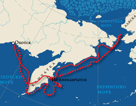
 The expedition covered the distance from Vologda to Tobolsk in 43 days. After a month's rest we hit the road again. The team spent almost the entire summer of 1725 on the road. They waited out the winter of 1725-26 in Ilimsk. On June 16, all expedition detachments arrived in Yakutsk. And only on July 30, 1727, in the third year after departure from St. Petersburg, Bering and his team in separate groups reached Okhotsk. Legend has it that Bering himself, from Yakutsk to Okhotsk, spent 45 days in the saddle! Upon arrival in Okhotsk, without wasting any time, we began building the ship. In total, more than ten thousand miles were covered by water, on horseback, on sleds, on foot...
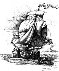
On August 22, 1727, the newly built ship, the galliot Fortuna, and the accompanying small boat, which arrived from Kamchatka, left Okhotsk and headed east.
Galiot is a two-masted shallow-slung vessel.
From Okhotsk to Nizhnekamchatsk
The journey from Okhotsk to the western coast of Kamchatka took a week, and on August 29, 1727, travelers were already sailing in view of the Kamchatka coast. What happened next is difficult to explain logically. Despite the fact that the Russians had already more or less settled in Kamchatka by that time, Bering had no idea about the size of the peninsula. There was even an opinion that Kamchatka smoothly passes into Japan, and that there is no through route to the east... Bering did not even suspect that there was very little left to the southern point of Kamchatka.
Therefore, the expedition commander decided to land on the west bank and during the winter move to the east bank, to Nizhnekamchatsk. There they decided to build a new ship and begin the main research from there. (According to other sources, the hastily built Fortuna developed a strong leak, and the expedition was forced to land on shore). Be that as it may, Bering went to the mouth of the Bolshaya River and ordered to drag equipment and supplies to the shore.
Bering's journey through the Kamchatka Peninsula
IN Central Archives The Navy has preserved Bering's reports to the Admiralty Board about his passage across Kamchatka:
“...Upon arrival at the Bolsheretsky mouth, materials and provisions were transported to the Bolsheretsky fort by water in small boats. There are 14 courtyards in this fort of Russian housing. And he sent up the Bystraya River in small boats heavy materials and some of the provisions, which were transported by water to the Upper Kamchadal fort, 120 versts. And that same winter, from the Bolsheretsky fort, they were transported to the Upper and Lower Kamchadal forts, completely according to local custom, on dogs. And every evening on the way for the night they raked out the snow for themselves, and covered it on top, because of the great blizzards, which in the local language are called blizzards.”
The description of the expedition's passage through the Kamchatka ridge, dragging all the property, including materials for building ships, weapons, ammunition, and food, took more than two months. The expedition covered more than 800 miles on foot, along rivers and on dog sleds! Truly a heroic feat.
To the Bering Strait in full sail
 Upon arrival in Nizhnekamchatsk of all cargo and crew members, the new ship was solemnly laid down. This happened on April 4, 1728. Construction proceeded unusually quickly. On June 9, the ship was already completed. And exactly a month later, on July 9, 1728, the well-puttyed and equipped boat "St. Gabriel" under full sail, with 44 crew members on board, left the mouth of the Kamchatka River and headed northeast.
The voyage north along the coast of Asia lasted just over a month. On August 11, 1728, the Saint Gabriel crossed the strait separating Asia from America. But at that time, the sailors could not know whether it was a strait or something else. The next day they noticed that the land past which they had walked on their previous course was left behind on the left. On August 13, the ship, driven by strong winds, crossed the Arctic Circle.
50 years later, Captain James Cook passed through this strait in search of the Northern Sea Route around America. He plotted his route using maps compiled by Vitus Bering.
Amazed by the accuracy of Russian sailing directions, James Cook proposed naming the strait between the continents after Bering. So, at the instigation of this great navigator, one of the most significant straits on earth received the name of our no less great compatriot.Bering's expedition completed its task
 On August 15, the expedition entered the open (Arctic) ocean and continued sailing to the north-northeast in complete fog. Many whales appeared. The vast ocean stretched all around. The Chukotka land no longer extended further to the north. There were no other lands in sight.
At this point, Bering decided that the expedition had completed its task. He did not find any American coastline in his line of sight. There was no isthmus further north. Having walked a little further north to clear his conscience, to latitude 67 "18", Bering on August 16, 1728 gave the order to return to Kamchatka, so as not to spend the winter on unfamiliar treeless shores “for no reason.” Already on September 2, 1728, “St. Gabriel” returned to Nizhnekamchatsk harbor. Here the expedition decided to spend the winter.
Bering understood that he had completed only part of the task. He did not find America. Therefore, in the summer of the following year, he and his associates made another attempt to break through to the American shores from the east. Setting out to sea in June 1729, the expedition sailed due east for 200 miles and encountered no sign of land.
There was nothing to do, we turned back. But on the way to Okhotsk, they bypassed Kamchatka from the south and established the exact southern tip of the peninsula. This discovery became extremely important and necessary for all subsequent expeditions. Oh, if they themselves knew the true size of Kamchatka, they wouldn’t have to drag the entire cargo hundreds of miles overland!
Vitus Bering. short biography. What did you open?
Russian travelers and pioneers
Again
travelers of the era of great geographical discoveriesactive development Far East Russia began under Peter 1 almost immediately after the Poltava victory and the end of the Northern War with the conclusion of peace with Sweden in 1721.
The opening of a sea route to Kamchatka would facilitate the study of the North Pacific Ocean. Peter 1 was interested in sea routes to India and China, the spread of Russian influence over the eastern part of the Pacific Ocean, and reaching the “unknown part” of North America, where the French and British had not yet reached.
Interest in India and China and the ways of penetration there grew in the world after Marco Polo in 1271 - 1295 traveled to China by land and returned back by sea, telling the world about the “kingdoms and wonders” of the East. In 1466, Afanasy Nikitin entered India, telling a description of his journey. Later, in 1453, the land routes there were blocked by the Ottoman Turks, who captured Constantinople, and Europe was forced to look for sea routes.
It was possible to open this path Vasco Yes Gama(through southern Africa), but at the same time the searches also went in a southwestern direction. Columbus , Balboa , Cabral , Magellan- opened to the world New World. Europe rushed to share this tasty morsel. Pope Alexander Boggia having arbitrated, he gave everything that lay to the west of the Azores to Spain, to the east to Portugal, which was, in general, a fair decision... for Spain and Portugal... But, to their great chagrin, at that moment they already existed and other maritime powers - England, France, Holland. The showdown dragged on for centuries, from which, as we now know, England emerged right in all respects and declared itself the mistress of the seven seas.
Russia by that time had already become a maritime power and, naturally, could not cede half the world to the powerful, but still tiny England. Therefore, the issue of conquering the seas and penetrating China has always been relevant for the empire that was beginning to gain strength.
Somewhere there was a still unknown “land of da Gama”, rich in fur.
In January 1725, Peter 1 ordered the preparation of an expedition to the Pacific Ocean to reach the shores of North America. The expedition was supposed to reach some “city of European possessions” in America:
I. It is necessary to make one or two boats with decks in Kamchatka, or another place there.
II. On these boats (sail) near the land that goes to the north, and according to hope (they don’t know it) it seems that that land is part of America.
III. And in order to look for where it came into contact with America, and to get to which city of European possessions; and if they see a European ship, find out from him what this bush is called, and take it in writing and visit the shore yourself and take the original report and, putting it on the map, come here.
In 1732, a ship under the command M. Gvozdeva came so close to the shores of America that the sailors were able to distinguish its shores, but the post-wind headwind again prevented the “Archangel Gabriel” from getting close to their cherished goal.
| IN |
In 1733, the government decided to organize the second Kamchatka expedition, also called Great Siberian or Great Siberian-Pacific.
Great hopes were placed on this expedition. The expedition was supposed to find shipping routes across the Arctic Ocean, explore routes to America and Japan, conduct cartographic research (clarification of the location of the “land of da Gama”), and study the life and customs of the peoples inhabiting these lands.
The expedition included naturalists, geographers, and historians. The future hero of this expedition George Steller I got into it only thanks to my persistence. Bering in every possible way refused to take on board a second physician, but the desire of the young naturalist... for all sorts of difficulties and labors, as well as the desire to visit newly invented places, was so strong that he obtained from Bering permission to remain on the ship not as a scientist or physician, but on any conditions.
| 4 |
June 1741 packet boats “ Holy Apostle Peter"under the leadership of Bering and" Holy Apostle Paul“under the command of Chirikov they set off for the shores of America. Bering tried to find the notorious “land of da Gama,” and Chirikov wanted to prove that America was not very far from the eastern corner of Chukotka.
Commander Bering vainly ironed the Pacific Ocean in a vain attempt to find the lost land. She didn’t exist then, and she hasn’t appeared now.
Storms tossed the ships... Bering's patience was running out (the patience of the crew, presumably, ended much earlier). And he gave the order to turn northeast... On June 20, in heavy fog, the ships lost each other. Next, they had to complete the task separately.
On July 15, Chirikov and his “Holy Apostle Paul” reached a land off the coast of America, now bearing the name of the first ruler of Russian settlements in America - the land of Baranov. Two days later, having sent a boat with a dozen sailors to land under the command of navigator Dementyev and not waiting for their return within a week, he sends a second one with four sailors to search for his comrades. Without waiting for the return of the second boat and not being able to approach the shore, Chirikov gave the order to continue sailing.
“Saint Apostle Paul” visited some of the islands of the Aleutian chain.
And in the land where we walked and examined about 400 miles, we saw whales, sea lions, walruses, pigs, birds... a lot of... On this land everywhere there are high mountains and the shores to the sea are steep... and on the mountains nearby from the place where they came to the land, as shown above, the forest was quite large... Our shore turned out to be on the western side, 200 fathoms away... They came to us in 7 small leather trays, each with one person... And in the afternoon... we came to our ship in the same 14 trays, one person at a time.
After visiting the islands of the Aleutian ridge, "St. Apostle Paul" headed for Kamchatka and on October 12, 1741, arrived at Peter and Paul Harbor.
The packet boat "St. Apostle Peter" was looking for "St. Apostle Paul" from the very first day of their separation, Bering did not even suspect that he was located next to the ridge of islands that Chirikov had already visited. Arguments of Georg Steller, who observed seagulls in the sea, that there should be land nearby and the need to turn north did not have any effect on the captain-commander, who was preoccupied with the disappearance of the ship, and even on the contrary - they irritated the experienced 60-year-old Bering. The commander wandered for another two months in the hope of finding the “St. Apostle Paul.” But, it seemed, failures followed him The "Earth da Gama" was never found, the ship was lost... It was impossible to delay any further - the entire expedition was in jeopardy... And on July 14, the naval master Sofron Khitrovo, after a long meeting, made the necessary entry in the ship’s log for these cases:
And before we left the harbor, on the designated course south-east-shadow-east, we sailed not only up to 46, but also up to 45 degrees, but we didn’t see any land... For this reason, they decided to change one point, keep closer to the north, that is, to go east-north-east...
The loss of hopes of finding the “land da Gama” and Chirikov’s ship were not the only reasons that forced the commander to change course - out of 102 barrels of water, only half remained; he had to return to Petropavlovsk no later than the end of September if the coast of America was found. But he was not there... On July 14, the packet boat "St. Peter the Apostle" went to the northern latitudes, and a day later Steller saw the outlines of the earth.
In the morning, with clear weather, all doubts disappeared. But due to weak winds, the packet boat was able to approach the shore only on July 20.
This was the American northwest.
| N |
Several sailors, officer Sofron Khitrovo and naturalist Steller set foot on the long-awaited shore.
Anyone can easily imagine how great was the joy of everyone when we finally saw the shore; congratulations poured in from all sides to the captain, who was most responsible for the honor of the discovery, wrote Steller, excited by the event. Only Bering did not share the general rejoicing - he was already ill. The burden of responsibility for the expedition, failures at the very beginning of the journey - all this greatly depressed Vitus Bering. Everyone rejoiced at the sheer success, the glimpses of future glory, but it was also necessary to return. Only wise with long experience of navigation, elderly, striving for this goal for 9 years, and finally having received it, Bering realized this: Who knows whether the trade winds will delay us here? The coast is unfamiliar to us; we don’t have enough food to survive the winter.
Doctor historical sciences V. Pasetsky.
Vitus Ionassen (Ivan Ivanovich) Bering A681-1741) belongs to the number of great navigators and polar explorers of the world. The sea that washes the shores of Kamchatka, Chukotka and Alaska, and the strait that separates Asia from America bears his name.
Science and life // Illustrations
Science and life // Illustrations
Science and life // Illustrations
Science and life // Illustrations
Science and life // Illustrations
Science and life // Illustrations
Science and life // Illustrations
Bering stood at the head of the greatest geographical enterprise, the like of which the world did not know until the middle of the 20th century. The First and Second Kamchatka Expeditions, led by him, covered with their research the northern coast of Eurasia, all of Siberia, Kamchatka, the seas and lands of the northern part of the Pacific Ocean, and discovered the northwestern shores of America, unknown to scientists and navigators.
The essay about the two Kamchatka expeditions of Vitus Bering, which we are publishing here, was written based on documentary materials stored in the TsGAVMF (Central state archive Navy). These are decrees and resolutions, personal diaries and scientific notes of expedition members, ship logs. Many of the materials used have not been published before.
Vitus Beriag was born on August 12, 1681 in Denmark, in the city of Horsens. He bore the surname of his mother Anna Bering, who belonged to the famous Danish family. The navigator's father was a church warden. Almost no information has been preserved about Bering’s childhood. It is known that as a young man he took part in a voyage to the shores of the East Indies, where he had gone earlier and where his brother Sven spent many years.
Vitus Bering returned from his first voyage in 1703. The ship on which he sailed arrived in Amsterdam. Here Bering met with the Russian admiral Cornelius Ivanovich Cruys. On behalf of Peter I, Kruys hired experienced sailors for the Russian service. This meeting led Vitus Bering to serve in the Russian navy.
In St. Petersburg, Bering was appointed commander of a small ship. He delivered timber from the banks of the Neva to the island of Kotlin, where, by order of Peter I, a naval fortress was created - Kronstadt. In 1706, Bering was promoted to lieutenant. He had many responsible assignments: he monitored the movements of Swedish ships in the Gulf of Finland, sailed in the Sea of Azov, ferried the Pearl ship from Hamburg to St. Petersburg, and made a voyage from Arkhangelsk to Kronstadt around the Scandinavian Peninsula.
Twenty years passed in labor and battles. And then came a sharp turn in his life.
On December 23, 1724, Peter I gave instructions to the Admiralty Boards to send an expedition to Kamchatka under the command of a worthy naval officer.
The Admiralty Board proposed to put Captain Bering at the head of the expedition, since he “was in the East Indies and knows his way around.” Peter I agreed with Bering's candidacy.
On January 6, 1725, just a few weeks before his death, Peter signed instructions for the First Kamchatka Expedition. Bering was ordered to build two deck ships in Kamchatka or in another suitable place. On these ships it was necessary to go to the shores of the “land that goes north” and which, perhaps (“they don’t know the end of it”), is part of America, that is, to determine whether the land going north really connects with America.
In addition to Bering, naval officers Alexei Chirikov, Martyn Shpanberg, surveyors, navigators, and ship's foremen were appointed to the expedition. A total of 34 people went on the trip.
Petersburg was left in February 1725. The path lay through Vologda, Irkutsk, Yakutsk. This difficult campaign lasted for many weeks and months. Only at the end of 1726 the expedition reached the shores of the Sea of Okhotsk.
Construction of the vessel began immediately. The necessary materials were delivered from Yakutsk throughout the winter. This was associated with many difficulties.
On August 22, 1727, the newly built ship “Fortuna” and the small boat accompanying it left Okhotsk.
A week later, the travelers saw the shores of Kamchatka. Soon a strong leak opened in the Fortuna. They were forced to go to the mouth of the Bolshaya River and unload the ships.
Bering's reports to the Admiralty Board, preserved in the Central State Archives of the Navy, give an idea of the difficulties that travelers encountered in Kamchatka, where they stayed for almost a year before they could set sail again, further to the North.
“...Upon arrival at the Bolsheretsky mouth,” Bering wrote, “materials and provisions were transported to the Bolsheretsky fort by water in small boats. There are 14 courtyards in this fort of Russian housing. And he sent up the Bystraya River in small boats heavy materials and some of the provisions, which were transported by water to the Upper Kamchadal fort, 120 versts. And that same winter, they were transported from the Bolsheretsky fort to the Upper and Lower Kamchadal forts, completely according to local custom, on dogs. And every evening on the way for the night they raked out the snow for themselves, and covered it on top, because of the great blizzards, which in the local language are called blizzards. And if a blizzard catches a clean place, and they don’t have time to make a camp for themselves, then it covers people with snow, which is why “they die.”
On foot and on dog sleds they walked across Kamchatka more than 800 miles to Nizhne-Kamchatsk. The bot “St. Gabriel". On July 13, 1728, the expedition set sail again on it.
On August 11, they entered the strait that separates Asia from America and now bears the name of Bering. The next day, the sailors noticed that the land they were sailing past was left behind. On August 13, the ship, driven by strong winds, crossed the Arctic Circle.
Bering decided that the expedition had completed its task. He saw that the American coast was not connected to Asia, and was convinced that there was no such connection further north.
On August 15, the expedition entered the open Arctic Ocean and continued sailing to the north-northeast in fog. Many whales appeared. The vast ocean stretched all around. The Chukotka land, according to Bering, did not extend further to the north. America did not come close to the “Chukchi corner”.
The next day of sailing, too, there were no signs of the coast either in the west, or in the east, or in the north. Having reached 67°18"N latitude, Bering gave the order to return to Kamchatka, so as not to spend the winter on unfamiliar treeless shores “for no reason.” On September 2, “St. Gabriel” returned to the Lower Kamchatka harbor. Here the expedition spent the winter.
As soon as the summer of 1729 arrived, Bering set sail again. He headed east, where, according to Kamchatka residents, on clear days the land could sometimes be seen “across the sea.” During last year’s voyage, the travelers “didn’t happen to see her.” Berig decided to “find out for sure” whether this land really exists. Strong northern winds were blowing. With great difficulty, the navigators covered 200 kilometers, “but only saw no land,” Bering wrote to the Admiralty Board. The sea was enveloped in a “great fog,” and with it a fierce storm began. We set a course for Okhotsk. On way back For the first time in the history of navigation, Bering circumnavigated and described the southern coast of Kamchatka.
On March 1, 1730, Bering, Lieutenant Shpanberg and Chirikov returned to St. Petersburg. The St. Petersburg Gazette published correspondence about the completion of the First Kamchatka Expedition of Vitus Bering. It was reported that Russian sailors on ships built in Okhotsk and Kamchatka ascended to the Polar Sea well north of 67° N. w. and thereby proved (“invented”) that “there is a truly northeastern passage there.” The newspaper further emphasized: “Thus, from Lena, if ice did not interfere in the northern country, it would be possible to travel by water to Kamchatka, and also further to Japan, Hina and the East Indies, and besides, it (Bering.- V.P.) and from the local residents I learned that before 50 and 60 years a certain ship from Lena arrived to Kamchatka.”
The first Kamchatka expedition made a major contribution to the development of geographical ideas about the northeastern coast of Asia, from Kamchatka to the northern shores of Chukotka. Geography, cartography and ethnography have been enriched with new valuable information. The expedition created a series of geographical maps, of which the final map is of particularly outstanding importance. It is based on numerous astronomical observations and for the first time gave a real idea not only of the eastern coast of Russia, but also of the size and extent of Siberia. According to James Cook, who named the Bering Strait between Asia and America, his distant predecessor “mapped the coast very well, determining the coordinates with an accuracy that would have been difficult to expect with his capabilities.” The first map of the expedition, which shows the areas Siberia in the space from Tobolsk to the Pacific Ocean, was reviewed and approved by the Academy of Sciences. The resulting map was also immediately used by Russian scientists and soon spread widely in Europe. In 1735 it was engraved in Paris. A year later published in London, then again in France And then this map was repeatedly republished as part of various atlases and books... The expedition determined the coordinates of 28 points along the route Tobolsk - Yeniseisk - Ilimsk - Yakutsk - Okhotsk-Kamchatka-Chukotsky Nose - Chukchi Sea, which were then included in the “Catalogue of Cities and Notables” Siberian places, put on the map, through which the route was, what width and length they were.”
And Bering was already developing a project for the Second Kamchatka Expedition, which later turned into an outstanding geographical enterprise, the like of which the world had not known for a long time.
The main place in the program of the expedition, of which Bering was appointed head, was given to the study of all of Siberia, the Far East, the Arctic, Japan, and northwestern America in geographical, geological, physical, botanical, zoological, and ethnographic terms. Particular importance was attached to the study of the Northern Sea Passage from Arkhangelsk to the Pacific Ocean.
At the beginning of 1733, the main detachments of the expedition left St. Petersburg. More than 500 were sent from the capital to Siberia naval officers, scientists, sailors.
Bering, together with his wife Anna Matveevna, went to Yakutsk to supervise the transfer of cargo to the port of Okhotsk, where five ships were to be built for sailing the Pacific Ocean. Bering monitored the work of the teams of X. and D. Laptev, D. Ovtsyn, V. Pronchishchev, P. Lassinius, who were engaged in the study of the northern coast of Russia, and the academic team, which included historians G. Miller and A. Fischer, naturalists I. Gmelin, S. Krasheninnikov, G. Steller, astronomer L. Delyakroer.
Archival documents give an idea of the unusually active and versatile organizational work of the navigator, who led from Yakutsk the activities of many detachments and units of the expedition, which conducted research from the Urals to the Pacific Ocean and from the Amur to the northern shores of Siberia.
In 1740, the construction of the packet boats “St. Peter" and "St. Pavel", on which Vitus Bering and Alexey Chirikov undertook the transition to Avachinskaya harbor, on the shore of which the Petropavlovsk port was founded.
152 officers and sailors and two members of the academic detachment went on the voyage on two ships. Bering assigned Professor L. Delyakroer to the ship “St. Pavel,” and took adjunct G. Steller to “St. Peter" to his crew. Thus began the path of a scientist who later gained worldwide fame.
On June 4, 1741, the ships went to sea. They headed southeast, to the shores of the hypothetical Land of Juan de Gama, which appeared on the map of J. N. Delisle and which was ordered to be found and explored along the way to the shores of northwestern America. Severe storms hit the ships, but Bering persistently moved forward, trying to accurately fulfill the Senate's decree. There was often fog. In order not to lose each other, the ships rang a bell or fired cannons. This is how the first week of sailing passed. The ships reached 47° N. sh., where the Land of Juan de Gama was supposed to be, but there were no signs of land. On June 12, travelers crossed the next parallel - no land. Bering ordered to go northeast. He considered his main task to be to reach the northwestern shores of America, which had not yet been discovered or explored by any navigator.
The ships had barely passed the first tens of miles north when they found themselves in dense fog. Packetboat "St. Pavel" under the command of Chirikov disappeared from sight. For several hours you could hear the bell ringing there, letting you know about your location, then the bell could no longer be heard, and deep silence lay over the ocean. Captain-Commander Bering ordered the cannon to be fired. There was no answer.
For three days Bering plowed the sea, as agreed, in those latitudes where the ships were separated, but never met the detachment of Alexei Chirikov.
For about four weeks the packet boat “St. Peter walked along the ocean, meeting only herds of whales along the way. All this time, storms mercilessly battered the lonely ship. Storms followed one after another. The wind tore the sails, damaged the spar, and loosened the fastenings. A leak appeared in some places in the grooves. The fresh water we had taken with us was running out.
“On July 17,” as recorded in the logbook, “from midday at half past one o’clock we saw land with high ridges and a hill covered with snow.”
Bering and his companions were impatient to land on the American coast they had discovered. But strong, variable winds blew. The expedition, fearing rocky reefs, was forced to stay away from the land and follow it to the west. Only on July 20 the excitement decreased and the sailors decided to lower the boat.
Bering sent naturalist Steller to the island. Steller spent 10 hours on the shore of Kayak Island and during this time managed to get acquainted with the abandoned dwellings of the Indians, their household items, weapons and remains of clothing, and described 160 species of local plants.
Late July to August “St. Peter walked now in the labyrinth of islands, now at a small distance from them.
On August 29, the expedition again approached the land and anchored between several islands, which were named Shumaginsky after the sailor Shumagin, who had just died of scurvy. Here the travelers first met the inhabitants of the Aleutian Islands and exchanged gifts with them.
September came, the ocean was stormy. The wooden ship could hardly withstand the onslaught of the hurricane. Many officers began to talk about the need to stay for the winter, especially as the air became increasingly cold.
The travelers decided to hurry to the shores of Kamchatka. More and more alarming entries appear in the logbook, indicating the difficult situation of the seafarers. Yellowed pages, hastily written by the officers on duty, tell how they sailed day after day without seeing land. The sky was overcast with clouds, through which a ray of sunlight did not break through for many days and not a single star was visible. The expedition could not accurately determine its location and did not know at what speed they were moving towards their native Petropavlovsk...
Vitus Bering was seriously ill. The illness was further intensified by dampness and cold. It rained almost continuously. The situation became more and more serious. According to the captain's calculations, the expedition was still far from Kamchatka. He understood that he would reach his native promised land no earlier than the end of October, and this only if the western winds changed to fair eastern ones.
On September 27, a fierce squall hit, and three days later a storm began, which, as noted in the logbook, created “great excitement.” Only four days later the wind decreased somewhat. The respite was short-lived. On October 4, a new hurricane hit, and huge waves again hit the sides of the St. for several days. Petra."
Since the beginning of October, most of the crew had already become so weak from scurvy that they could not take part in the ship's work. Many lost their arms and legs. Food supplies were dwindling catastrophically...
After enduring a severe storm that lasted many days, “St. Peter” again began, despite the headwind from the west, to move forward, and soon the expedition discovered three islands: St. Marcian, St. Stephen and St. Abraham.
The dramatic situation of the expedition worsened every day. Not only was there not enough food, but also fresh water. The officers and sailors who were still standing were exhausted by backbreaking work. According to navigator Sven Waxel, “the ship floated like a piece of dead wood, almost without any control and went at the will of the waves and wind, wherever they wanted to drive it.”
On October 24, the first snow covered the deck, but, fortunately, it did not last long. The air became more and more chilly. On this day, as noted in the logbook, there were “28 people of various ranks” who were sick.
Bering understood that the most crucial and difficult moment had arrived in the fate of the expedition. Himself, completely weakened by illness, he still went up on deck, visited the officers and sailors, and tried to raise faith in the successful outcome of the journey. Bering promised that as soon as land appeared on the horizon, they would certainly moor to it and stop for the winter. Team "St. Petra trusted her captain, and everyone who could move their legs, straining their last strength, corrected the urgent and necessary ship work.
On November 4, early in the morning, the contours of an unknown land appeared on the horizon. Having approached it, they sent officer Plenisner and naturalist Steller to the shore. There they found only thickets of dwarf willow spreading along the ground. Not a single tree grew anywhere. Here and there on the shore lay logs washed up by the sea and covered with snow.
A small river flowed nearby. In the vicinity of the bay, several deep holes were discovered, which, if covered with sails, could be converted into housing for sick sailors and officers.
The landing has begun. Bering was carried on a stretcher to the dugout prepared for him.
The disembarkation was slow. Hungry, weakened by illness, sailors died on the way from ship to shore or as soon as they set foot on land. So 9 people died, 12 sailors died during the voyage.
On November 28, a strong storm tore the ship from its anchors and threw it ashore. At first, the sailors did not attach serious importance to this, since they believed that they had landed on Kamchatka and that the local residents would help the dogs to get to Petropavlovsk.
The group sent by Bering for reconnaissance climbed to the top of the mountain. From above, they saw that the vast sea spread out around them. They landed not in Kamchatka, but on an uninhabited island lost in the ocean.
“This news,” wrote Svei Vaksel, “impacted on our people like a thunderclap. We clearly understood what a helpless and difficult situation I found myself in, that we were threatened with complete destruction.”
During these difficult days, the illness tormented Bering more and more. He felt that his days were numbered, but continued to take care of his people.
The captain-commander lay alone in a dugout, covered with a tarpaulin on top. Bering suffered from the cold. His strength was leaving him. He could no longer move either his arm or his leg. The sand sliding from the walls of the dugout covered the legs and lower part of the body. When the officers wanted to dig it up, Bering objected, saying that it was warmer. In these last, most difficult days, despite all the misfortunes that befell the expedition, Bering did not lose his courage, he found sincere words to encourage his despondent comrades.
Bering died on December 8, 1741, unaware that last refuge The expedition is located within a few days of good sailing from Petropavlovsk.
Bering's companions survived a difficult winter. They ate the meat of sea animals, which were found here in abundance. Under the leadership of officers Sven Vaksel and Sofron Khitrovo, they built a new ship from the wreckage of the packet boat "St. Peter". On August 13, 1742, the travelers said goodbye to the island, which they named after Bering, and safely reached Petropavlovsk. There they learned that the packet boat “St. Pavel,” commanded by Alexey Chirikov, returned to Kamchatka last year, discovering, like Bering, the northwestern shores of America. These lands were soon named Russian America (now Alaska).
Thus ended the Second Kamchatka Expedition, whose activities were crowned with great discoveries and outstanding scientific achievements.
Russian sailors were the first to discover the previously unknown northwestern shores of America, the Aleutian ridge, the Commander Islands and crossed out the myths about the Land of Juan de Gama, which Western European cartographers depicted in the north of the Pacific Ocean.
Russian ships were the first to pave the sea route from Russia to Japan. Geographical science has received accurate information about the Kuril Islands and Japan.
The results of discoveries and research in the North Pacific Ocean are reflected in a whole series of maps. Many of the surviving members of the expedition took part in their creation. A particularly outstanding role in summarizing the materials obtained by Russian sailors belongs to Alexei Chirikov, one of the brilliant and skillful sailors of that time, Bering’s devoted assistant and successor. It fell to Chirikov to complete the affairs of the Second Kamchatka Expedition. He compiled a map of the North Pacific Ocean, which shows with amazing accuracy the path of the ship "St. Pavel,” the northwestern shores of America, the islands of the Aleutian ridge and the eastern shores of Kamchatka, discovered by sailors, which served as the starting base for Russian expeditions.
Officers Dmitry Ovtsyn, Sofron Khitrovo, Alexey Chirikov, Ivan Elagin, Stepan Malygin, Dmitry and Khariton Laptev compiled the “Map Russian Empire, northern and eastern coasts adjacent to the Arctic and Eastern oceans with part of the western American coasts and the island of Japan newly discovered through sea navigation.”
Equally fruitful was the activity of the northern detachments of the Second Kamchatka Expedition, which were often separated into an independent Great Northern Expedition.
As a result of sea and foot voyages of officers, navigators and surveyors operating in the Arctic, the northern coast of Russia from Arkhangelsk to Bolshoy Baranov Kamen, located east of Kolyma, was explored and mapped. Thus, according to M.V. Lomonosov, the passage of the sea from the Arctic Ocean to the Pacific was “undoubtedly proven.”
To study the meteorological conditions of Siberia, observation points were created from the Volga to Kamchatka. The world's first experience of organizing a meteorological network over such a vast area was a brilliant success for Russian scientists and sailors.
On all ships of the Second Kamchatka Expedition, which sailed across the polar seas from Arkhangelsk to Kolyma, across the Pacific Ocean to Japan and northwestern America, visual and, in some cases, instrumental meteorological observations were carried out. They were included in the log books and have survived to this day. Today, these observations are of particular value also because they reflect the characteristics of atmospheric processes during years of extremely increased ice cover in the Arctic seas.
The scientific heritage of Vitus Bering's Second Kamchatka Expedition is so great that it has not yet been fully mastered. It was and is now widely used by scientists in many countries.
Danish navigator, captain-commander of the Russian fleet
Led the 1st and 2nd Kamchatka expeditions. Passed between the Chukotka Peninsula and Alaska, confirming the presence of a strait separating them (later the strait between Russia and the USA was called Bering Strait), reached North America and discovered a number of islands in the Aleutian chain.
An island, a strait, an underwater canyon, a river, a lake, a glacier, two capes, a street in the city of Petropavlovsk-Kamchatsky, a sea in the North Pacific Ocean, as well as the Commander Islands are named after the great navigator. In archeology, the northeastern part of Siberia, Chukotka and Alaska (which are now believed to have been previously connected by a strip of land) are often referred to by the general term Beringia.
Brief chronology
1703 graduated from the Amsterdam Naval Cadet Corps
1704, with the rank of second lieutenant, he entered service in Russian fleet, to the Baltic
1710-12 transferred to the Azov Fleet, participated in the war with Turkey
1715 promoted to captain 4th rank
1725-30 headed The first Kamchatka expedition, surveyed and mapped the Pacific coast of Kamchatka and Northeast Asia
1733-41 headed Second Kamchatka expedition, during which it was possible to map the northern and eastern coasts of Russia, internal territories Eastern Siberia, explored routes to America and Japan, discovered the coast of North-West America, the islands of the Kuril and Aleutian chains
1741, under difficult conditions of forced wintering on the island, later named after Bering, the captain-commander died. The great navigator was buried on Bering Island in Commander Bay.
Life story
Bering Vitus Jonassen born in 1681 in the Danish city of Horsens, graduated from the cadet corps in Amsterdam in 1703, in the same year he was accepted into the Baltic Fleet with the rank of second lieutenant, and in 1707 he was promoted to lieutenant. In 1710, he was transferred to the Azov Fleet, promoted to captain-lieutenant, and commanded the shrewd Munker. In 1712 he was transferred to the Baltic Fleet, in 1715 he was promoted to captain of the 4th rank.

In 1716 he commanded the ship Pearl. In 1717 he was promoted to captain of the 3rd rank. In 1719 he commanded the ship "Selafail". In 1720 he was promoted to captain of the 2nd rank, commanded the ship "Malburg", then the ship "Lesnoye". In 1724, he was dismissed from service at his request, and then re-employed as commander of the Selafail with the rank of captain 1st rank.
From 1725 to 1730 - boss First Kamchatka expedition. In the middle of the summer of 1728, he explored and mapped the Pacific coast of Kamchatka and Northeast Asia. He discovered two peninsulas (Kamchatsky and Ozerny), Kamchatka Bay, Karaginsky Bay with Karaginsky Island, Cross Bay, Providence Bay and St. Lawrence Island.
In the Chukchi Sea, passing through the Strait (later called the Bering Strait), the expedition reached 62° 24′ With. sh., but because of the tum Ana and the wind did not find the ground and turned back. The following year, Bering managed to move 200 kilometers east from Kamchatka, inspect part of the Kamchatka coast and identify Avacha Bay and Avacha Bay. The discoverer first surveyed over 3,500 kilometers of the western coastline of the sea, later called the Bering Sea.
In 1730 he was promoted to captain-commander.
After returning to St. Petersburg at the end of April 1730, Bering proposed a plan to explore the northern coast of the continent and reach the mouth of the Amur River, the Japanese Islands and America by sea.
Bering was appointed chief Second Kamchatka (Great Northern) Expedition, A. Chirikov became his deputy. On June 4, 1741, Bering and Chirikov, commanding two packet boats, headed from the shores of Kamchatka to the southeast in search of the “land of Joao da Gama,” located on some maps of the 18th century between 46 and 50 ° N. w. For more than a week, the pioneers searched in vain for even a piece of land in the North Pacific Ocean. Both ships headed northeast, but on June 20, due to thick fog, they separated forever. Bering searched for Chirikov for three days: he walked south about 400 kilometers, then moved northeast and crossed the central waters of the Gulf of Alaska for the first time. July 17 at 58° N. w. noticed the ridge (St. Elijah), but did not experience the joy of discovering the American coast: I felt unwell due to worsening heart disease.
In August - September, continuing his voyage along the coast of America, Bering discovered Tumanny Island (Chirikova), five islands (Evdokeevsky), snow mountains (Aleutian Range) on the “mother coast” (Alaska Peninsula), at the southwestern edge of which he discovered the Shumagin Islands and met the Aleuts for the first time. Continuing to go west, sometimes in the north I saw land - separate islands of the Aleutian chain. On November 4, a wave washed the ship to the ground, which turned out to be an island. Here the captain-commander died; 14 people from his detachment died of scurvy. The island was subsequently named after Bering.

Buried on Bering Island in Commander Bay. There are four monuments at the site of Bering's death. Directly at the burial site today there is an iron cross 3.5 m high. At its foot there is a cast-iron plaque with the inscription: “1681-1741. To the great navigator Captain-Commander Vitus Bering from the inhabitants of Kamchatka June 1966.”
Being inquisitive by nature and how enlightened monarch, concerned about the benefits for the country, the first Russian emperor was keenly interested in descriptions of travel. The king and his advisers knew about the existence of Anian - that was the name then of the strait between Asia and America - and hoped to use it for practical purposes. At the end of 1724 Peter I I remembered “... something that I had been thinking about for a long time and that other things prevented me from doing, that is, about the road through the Arctic Sea to China and India... Wouldn’t we be happier in exploring such a route than the Dutch and the British?...” and, without putting it off for a long time, , drew up an order for the expedition. Its chief was appointed captain 1st rank, later captain-commander, 44-year-old Vitus Jonassen (in Russian usage - Ivan Ivanovich) Bering, who had already served in Russia for 21 years. The Tsar handed him a secret instruction, written in his own hand, according to which Bering was to reach a large land mass, supposedly extending in a northwesterly direction near the coast of Kamchatka. coast of Kamchatka, walk along the coast, find out whether it connects with North America, and trace the coast of the mainland south to the possessions of European states. The official task was to resolve the question of “whether America has converged with Asia” and to open the Northern Sea Route.
Initially consisting of 34 people, it set off on the road from St. Petersburg on January 24, 1725. Moving through Siberia, they walked to Okhotsk on horseback and on foot, on ships along the rivers. The last 500 km from the mouth of the Yudoma to Okhotsk, the heaviest loads were dragged by harnessing ourselves to sledges. Terrible frosts and hunger reduced the expedition by 15 people. The advance detachment led by V. Bering arrived in Okhotsk on October 1, 1726, and the group that brought up the rear of the expedition, Lieutenant Martyn Petrovich Shpanberg, a Dane in the Russian service, got there only on January 6, 1727. To survive until the end of winter, people had to build several huts and sheds.

The road through the expanses of Russia took 2 years. Along this entire path, equal to a quarter of the length of the earth's equator, Lieutenant Alexei Ilyich Chirikov identified 28 astronomical points, which made it possible for the first time to reveal the true latitudinal extent of Siberia, and, consequently, the northern part of Eurasia.
The expedition members traveled from Okhotsk to Kamchatka on two small ships. To continue the journey at sea, it was necessary to build and equip the boat “St. Gabriel,” on which the expedition set out to sea on July 14, 1728.
As the authors of “Essays on the History of Geographical Discoveries” note, V. Bering, having misunderstood the king’s plan and violated the instructions that prescribed first going south or east from Kamchatka, headed north along the coast of the peninsula, and then northeast along the mainland .
“As a result,” the “Essays...” goes on, “more than 600 km of the northern half of the eastern coast of the peninsula were photographed, and Kamchatsky Peninsula And Ozernoy, and Karaginsky Bay with the island of the same name... The sailors also put 2,500 km of the coastline of Northeast Asia on the map. Along most of the coast they noted high mountains, covered with snow in summer, approaching in many places directly to the sea and rising above it like a wall.” In addition, they opened Bay of the Cross(not knowing that it had already been discovered by K. Ivanov), Provideniya Bay And St. Lawrence Island.
However, the desired part of the land still did not appear. V. Bering, not seeing either the American coast or the turn to the west of the Chukotka coast, ordered A. Chirikov and M. Shpanberg to express their opinions in writing whether the existence of a strait between Asia and America can be considered proven, whether to move further to the north and how far . As a result of this “written meeting,” Bering decided to go further north. On August 16, 1728, the sailors passed through the strait and ended up in the Chukchi Sea. Then Bering turned back, officially motivating his decision by the fact that everything required according to the instructions had been done, the coast did not extend further to the north, and “nothing approached the Chukotsky, or Eastern, corner of the land.” After spending another winter in Nizhnekamchatsk, in the summer of 1729 Bering again made an attempt to reach the American coast, but, having traveled a little more than 200 km, due to strong wind and fog he ordered to return.
The first expedition described the southern half of the eastern and a small part of the western coast of the peninsula for more than 1000 km between the mouths of Kamchatka and Bolshaya, revealing Kamchatka Bay And Avacha Bay. Together with Lieutenant A.I. Chirikov and midshipman Pyotr Avraamovich Chaplin, Bering compiled the final map of the voyage. Despite a number of errors, this map was much more accurate than the previous ones and was highly appreciated by D. Cook. Detailed description the first marine scientific expedition in Russia was preserved in the ship's log, which was kept by Chirikov and Chaplin.
The Northern Expedition would not have achieved success without auxiliary campaigns led by Cossack Colonel Afanasy Fedotovich Shestakov, Captain Dmitry Ivanovich Pavlutsky, surveyor Mikhail Spiridonovich Gvozdev and navigator Ivan Fedorov.
It was M. Gvozdev and I. Fedorov who completed the opening of the strait between Asia and America, begun by Dezhnev and Popov. They examined both shores of the strait, the islands located in it, and collected all the materials needed to put the strait on the map.
Returning from the expedition, Bering proposed to the government a plan for a new large expedition and expressed his readiness to take part in it. In 1733, he was appointed head of the Second Kamchatka Expedition. His assistant (“comrade”) became A.I. Chirikov, by this time already a captain.
Their task was to explore the American coast from Kamchatka. At the same time, M. Shpanberg was supposed to sail to Japan and establish contact with it, and several detachments were to map the northern shores of Russia from Pechora to the extreme northeast and, if possible, to Kamchatka. An Academic detachment was also formed, whose task was to explore the interior regions of Siberia. The northern detachments worked independently, but all their activities were controlled by V. Bering. The work of the expedition was designed for 6 years.

At the beginning of 1734, V. Bering gathered all the participants of the expedition in Tobolsk. From here several land parties of surveyors left to study the ocean coast. Bering himself headed to Yakutsk, where he had to spend three years. There, under his leadership, an ironworks and a rope workshop were built, the collection of resin, the manufacture of rigging for ships was organized, and equipment and food were sent to Okhotsk for M. Shpanberg’s detachment.
In total, about 800 members of the expedition teams gathered in Yakutsk. The local administration, which was irritated by Bering’s incorruptibility and exactingness, created obstacles to the procurement of food and equipment and wrote denunciations to St. Petersburg against the stubborn “German.” However, V. Bering left Yakutsk only after making sure that the team was fully provided with provisions. In Okhotsk he also had to deal with disorder and corruption of local authorities. The capital's authorities, as is usual in Rus', trusted the denunciations of idlers and bribe-takers, and not the reports of the honest and pedantic Bering.
Finally, at the beginning of September 1740, V. Bering sailed from Okhotsk on two 200-ton ships with crews of 75 people. The ships were named after the apostles of Christ - “St. Peter" and "St. Paul". The expedition spent the winter on the eastern coast of Kamchatka, near Avacha Bay. And on June 4, 1741, eight years after leaving St. Petersburg, Bering ships And Chirikova reached the shores of America. The expedition included the young scientist Georg Wilhelm Steller and Sven (Xavier) Lavrentievich Waxel, who left interesting descriptions this voyage.
As mentioned above, on German map, which Bering used, the mythical land was applied. In search of this non-existent land, V. Bering first went to the southeast, to the coordinates indicated on this map. Having lost more than a week in vain and making sure that there was no land in this part of the ocean, the ships headed northeast. But on June 20, thick fog fell on the sea, and the ships were separated forever. From this day on, “St. Peter" and "St. Pavel" made voyages in autonomous mode.
"St. Peter" finally reached the American shore on July 17, 1741. From the deck of the ship one could see the shore and, in the distance, the snowy ridge of St. Elias, almost merging with the clouds, with its peak, Mount St. Elias, 5488 m high. The goal set by the emperor 17 years ago was achieved. But the sixty-year-old captain-commander did not share the joy and triumph of the team. He suffered from scurvy and did not know exactly the coordinates of the ship’s location; acutely experiencing losses and failures, the experienced navigator saw the future in a gloomy light.
Without approaching the mainland, V. Bering moved west along the coast for 4 days. On July 21, he sent people for fresh water and, without even filling all the barrels, despite the stormy weather, headed west, towards the shores of Asia.
Scurvy has already killed a third of the crew. On August 10, despairing of moving forward due to a strong headwind, V. Bering decided to go straight to Kamchatka. On August 29, sailors discovered “treeless and deserted islands” off the southwestern tip of Alaska. The captain-commander called them the “Shumagin Islands” - in memory of the sailor buried on one of them. Moving all the time to the west in the open sea, the sailors periodically saw land in the north - it was the Aleutian chain. There the Russians first met with local residents - the Aleuts.
When high mountains covered with snow appeared in the distance on November 4, the sailors mistakenly decided that they had approached Kamchatka. Having landed on the shore, they dug rectangular holes in the sand. To adapt them for housing, roofs were made from sails. Many suffered from scurvy. 20 people died. Only 10 sailors were still standing. The sick Bering lay without getting up. As S.N. wrote in The Earthly Circle. Markov, “...everyone knows what happened next. Arctic foxes gnawed at Bering's boots when he was still alive. In his death throes, Bering buried himself in the sand to warm himself up a little.” After lying there for a whole month, he died on December 6, 1741.
The land to which his ship washed up later received his name and is called Bering Island, and the entire group was christened in honor of the deceased captain-commander Commander Islands. “The sea discovered by F. Popov and S. Dezhnev, along which V. Bering sailed so little in 1728, was called the Bering Strait, through which he was not the first to pass, but the same F. Popov and S. Dezhnev, caused on the map not by them, but by M. Gvozdev and I. Fedorov, and at the suggestion of D. Cook, it was named the Bering Strait. The unfortunate captain-commander Vitus Bering... came to exceptional posthumous glory."
Accepted the team Sven Waxel as senior crew officer. Bypassing new land, the sailors became convinced that they were on the island. The winter was difficult: frequent storms and hurricanes, unexpected earthquakes, scurvy... By the summer of 1742, 46 people remained alive, including the ten-year-old son of K.L. Vaksel Lorenz, future officer of the Russian fleet Lavrentiy Ksaverevich Vaksel.
The ship "St. Peter" was badly damaged, and it had to be dismantled in order to build a small ship of the same name from its parts. Since all three ship carpenters died of scurvy, the Krasnoyarsk Cossack Savva Starodubtsev took up shipbuilding and successfully completed the construction of a new ship. On August 13, the travelers went to sea and, due to the calm, moving mostly on oars, on August 26, 1742 they reached Petropavlovsk.
It is known from school textbooks that in 1725, by order of Peter I, the expedition of Vitus Bering set off from St. Petersburg towards Kamchatka. Its stated task was to clarify geographic map data and verify the existence of a strait between Asia and North America. However, according to modern historians, true goal swimming was completely different.
Springboard for attack on America
According to archival historical documents, the sea voyage was organized to study the possibility of seizing the lands of North America by the Russian crown. In this case, the support base Russian troops Kamchatka was to become, to the shores of which Bering was sent. Nevertheless, the official task of the expedition also had to be completed. When the ships reached the coast of the peninsula, Bering was faced with the question of what to do next. It was possible to continue sailing and, with full equipment, go around Kamchatka, reaching the strait separating Eurasia and North America. But there was a second option. In order not to once again expose officers and soldiers to the risk of sailing through the choppy northern seas, and also to let them feel solid ground under their feet, Bering invited the military members of the expedition to cross Kamchatka on foot. Then the ships would pick them up on the other side of the peninsula. At the same time, soldiers and officers had to scout out the most convenient places to build fortresses if Russia began military expansion into North America.
The second option was recognized as the best, and the bulk of the people came ashore. But carrying equipment and weapons was not an easy task. We decided to involve local residents - Kamchadals from the Itelmen tribe. They had been conquered by the Cossacks for thirty years and were perfect for the role of porters. But how to get them to help for free was a big question.
The fact is that the natives carefully paid taxes to the royal treasury in the form of animal skins. The sale of skins from Russia to Europe was extremely profitable, so nothing more was required from the Itelmens. However, they did not like the supremacy of white people. And then Bering suddenly fell out of the blue and wanted his team to be escorted free of charge, in the interests of the Tsar, across the entire peninsula. Plus, all this happened at the height of the hunting season, and the Itelmens were afraid that if they missed time, they would have nothing to pay the tax with, and this would lead to punitive measures from the local Cossacks.
First Kamchatka War
The cunning Dane Bering solved the problem by deception. He promised those who would help transport people and goods an exemption from the royal tax on skins for three years! How can I resist here? The Aborigines agreed. They had no idea that Bering, not having such powers, simply lied to them. When the scam was revealed, the navigator’s ships were already far away.
However, the Itelmens could not tolerate meanness and went to war against the tsarist administration, represented by the Cossacks. These events are preserved in history under the name “The First Kamchatka War.” First, the Cossack forts were captured. Then at night the Itelmens massacred the entire garrison of the Nizhnekamchatsk fortress, the main Russian fortification in Kamchatka. Only three Cossacks managed to escape and raised the alarm; however, at that moment it was too late. The peninsula returned to the rule of local tribes.
At that moment, ironically, one of Bering’s ships, the brig Gabriel, with soldiers and officers on board, was returning to St. Petersburg from North America. Armed sailors, having learned about the Kamchadal uprising, removed the ship's guns, went ashore and, besieging Nizhnekamchatsk, took it two days later. The rebellion was suppressed. The war between the surviving Cossacks and sailors and the local tribes became particularly fierce. Both sides fought extremely brutally and took no prisoners. The Cossacks won, and by 1732 they had completely captured Kamchatka for the second time.