Nowadays definition cardinal directions without modern technical devices is extremely necessary. Many people, finding themselves in conditions wildlife, eager to find out direction, in which to move to see incredible, pristine places. In places where no one has set foot, there are no maps or signs. Therefore, before you set off, you need to find complete information about the upcoming route. You must have a clear idea of where you are going, in which direction of the world your goal is located.
Local orientation is not only necessary when you go to discover new places. Very often it is needed if electronic devices refuse to function, or if you get lost or lose your way. In such a situation, all your tools for orientation are improvised objects and natural phenomena. This is quite enough to determine terrain, find out which side you need to continue your journey. If you know how to navigate day and night, then you will definitely not get lost and will be able to get to your planned location on time, safe and sound.
Method 1: using the sun and a clock

Finding the sides of the horizon using the sun and a clock is quite simple. To do this you need a clock with hands. It is important that they go right. You also need to understand exactly which side of the world you need to move towards.
- Point the hour hand towards the sun. Arrow and the sun should form one imaginary straight line.
- Draw a line in relation to number 1. Without changing the position of the dial, draw a line that will be directed from the center of the clock to number 1.
- The bisector between the hour hand and the line pointing to the number 1 will be your guide to the South. In other words, if the clock says 13:05, you point both hands at the sun. And they show you where the South is. If the clock says 12.05, then you need to draw a straight line between the number 12 and one o'clock in the afternoon. The arrow pointing to 12 should be directed towards the sun, and the imaginary straight line will point to the South.
- Draw a straight bisector line in relation to the opposite part of the dial. You have received a direction to the North.
Sun orientation is not 100% accurate. There may be minor errors here. However, this will not be a problem for understanding at least an approximate trajectory of movement.
Orientation by clock can only be carried out during the daytime. If you have walked a sufficient distance and it begins to get dark, then you need to stop orienting using the clock and the sun. Wait out the night, then continue along the given route.
Method 2: using sun and shade

If you need orientation , and you left a watch with a round dial at home, then you can determine the further direction of the journey only with the help of the sun. The sun is an excellent reference point, since it follows the same path every day and is almost always visible - even modern gadgets cannot boast of such constancy. The main thing is to be able to read the signs of the luminary, and it will definitely help you find the way.
- Take a long object. It is important that an accurate, visible shadow leaves it. As a rule, this is a long stick. Surely you have seen that in the center of any sundial there is a long rod. You need to find a similar one locally.
- Make a mark of the base and the place where the shadow of the object now ends. To do this, insert a stick into the ground. You can drive it deep enough. Then you will have your hands free for an extended period of time.
- Wait 1-2 hours. During this time, the shadow of the stick will shift from its original position.
- Make a new mark for the end of the shadow.
- Combine the two indicators. This can be done on the ground.
- You received the mark: East-West.
Your exact location depends on which hemisphere you are currently in. If this northern continent where you and I live, then your first notch will point to the West, and the second to the East.
Method 3: according to the sun and time of day

If you don’t have an object at hand that could cast a good shadow, and yours, for example, turned out to have an electronic dial, then good way determine the location - by the sun. The easiest way is to determine the cardinal directions by the rising and setting sun. In the morning time, you can stand facing the rising sun. Before you will be not only a beautiful horizon, but also the eastern side of the world. Accordingly, the West will be behind you. If you go astray at sunset, then the sun, which sets behind the horizon, will point you to the West. Everything is quite simple.
For orientation in the daytime, just wait until 13.00 and stand with your back to the sun - in this case, your shadow will point to the North, your right hand will point to the East, and your left hand will point to the West. All you need is observation and endurance.
Method 4: by stars.

It is very easy to navigate the cardinal directions at night using the stars. They are visible in clear weather. Especially clearly celestial bodies appear far from the bustle of the city.
- Find the big bear. This is a well-known bucket. Since childhood, almost everyone identifies it in the sky, first of all.
- Identify two stars located on the edges.
- Visually measure the distance between them.
- Extend this line five times.
- You will see the North Star. It points precisely in the direction of the North.
Complexity this method The fact is that Ursa Major and Ursa Minor, depending on the month and time of year, are at different angles to us. Consequently, visual determination of distance is not always correct.
But you can practice finding the north star in an urban environment. This will make your task much easier in the wilderness.
Navigating by the stars is not the only way to determine the future path. You can take the moon as a starting point.
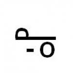
Method 5: by the moon.

In addition to the stars, it can help you navigate moon: if it is visible, then no compass you don't need it.
- Waxing moon (the sickle resembles the letter p). This position points to the West.
- Waning moon (resembles the letter c). Having seen such a moon, we can safely say that it points to the eastern hemisphere.
- In the evening the moon appears in the South.
- The full moon also points to the South.
Remember safety
When going into the wilderness, learning how to navigate in the forest and in unfamiliar terrain, be sure to take it with you. They will take up little space in your backpack, but will provide significant assistance on the road. These kits will help you heat water, light a fire, get food, bandage a wound, etc. However, even they will not be able to help you out if you do not know and understand exactly how to use them. On our website you will find a lot for yourself useful information, which we have prepared for professional tourists and amateurs who have been in natural nature just a few times.
Your safety is your ability to survive. The natural environment has its own laws. The important thing here is to stay strong and not panic.
When you realize that you need orientation, pull yourself together and, first of all, try to understand in which direction of the world you need to move. This is the basis on which your further actions are built. If you are lost and don’t know where to go, then the information presented earlier will help you in this matter.
When going on a hike, you need to put your things in a clean and dry backpack. If you don’t know how to properly wash a backpack, how to pack things, how to carry it so as not to injure your back and spine, then refer to our blog for information. Here you will find a lot of useful, practical information, which is constantly updated and supplemented.
You can navigate: by map, compass, sun, clock, stars, natural signs and phenomena and various clues. For example: if you look out the window in the morning and see people with umbrellas, it means it’s raining outside, and if it’s snowing, then most likely it’s winter and you need to dress warmer (just kidding).
Orientation is the ability to determine the cardinal directions, imagine the direction of roads and the location settlements in relation to the place where you are. You can always find the road if you know the location of the cardinal points. There are only four of them: north (N), east (E), south (S) and west (W).
Terrain orientation is one of the important conditions ensuring vital functions and successful completion of assigned tasks. Navigating the terrain using a map and compass is not very difficult. But sometimes you have to act without a map or compass. Therefore, when preparing for a hike, it is necessary to pay special attention to instilling solid skills in the basic techniques, rules and methods of navigating the terrain without a map and compass. Each member of the group must be able to navigate well and quickly in different terrain and in any weather conditions.
Orientation by the Sun.
The places of sunrise and sunset differ according to the seasons: in winter the Sun rises in the southeast and sets in the southwest; in summer the Sun rises in the northeast and sets in the northwest; In spring and autumn, the Sun rises in the east and sets in the west. At noon the Sun is always in the south direction. The shortest shadow from local objects occurs at 13 o'clock, and the direction of the shadow from vertically located local objects at this time will point to the north. If the sun is hidden by clouds, place a knife on your fingernail - even a small one, but a shadow will appear and it will become clear where the sun is.
According to the Sun and the clock.
It is necessary to point the hour hand towards the Sun, and divide the angle formed between the direction of the hour hand and the number 1 (13 o'clock) of the dial by an imaginary line in half. The line dividing this angle will indicate the direction: in front - south, behind - north. At the same time, we must remember that before 13 o’clock you need to divide the left corner, and in the second half of the day - the right corner.
According to the North Star.
The North Star is always in the north. To find the North Star, you must first find the constellation Ursa Major, which resembles a bucket made up of seven fairly bright stars, then mentally draw a line through the two extreme right stars of the Ursa Major, on which to plot five times the distance between these extreme stars, and then at the end of this line we will find the North Star, which, in turn, is located in the tail of another constellation called Ursa Minor. Facing the North Star, we will receive a direction to the north.
For approximate orientation, you need to know that in the summer in the first quarter the Moon is in the south at 20 o'clock, in the west at 2 o'clock in the morning, in the east at 2 o'clock in the last quarter, and in the south at 8 o'clock in the morning. When there is a full moon at night, the sides of the horizon are determined in the same way as by the Sun and the clock, and the Moon is taken for the Sun. It must be remembered that the full Moon opposes the Sun, i.e. is against him.
By melting snow.
It is known that the southern side of objects heats up more than the northern side, and accordingly, the melting of snow on this side occurs faster. It's clearly visible in early spring and during thaws in winter on the slopes of ravines, holes near trees, snow stuck to stones.
At noon, the direction of the shadow (it will be the shortest) points north. Without waiting for the shortest shadow, you can navigate in the following way. Stick a stick about 1 meter long into the ground. Mark the end of the shadow. Wait 10-15 minutes and repeat the procedure. Draw a line from the first shadow position to the second and extend one step beyond the second mark. Place the toe of your left foot opposite the first mark, and the toe of your right foot at the end of the line you drew. You are now facing north.
On local subjects.
The bark of most trees is coarser on the north side, thinner, more elastic (birch is lighter) on the south;
In pine, the secondary (brown, cracked) bark on the north side rises higher along the trunk;
On the north side, trees, stones, wooden, tiled and slate roofs are covered earlier and more abundantly with lichens and fungi;
On coniferous trees, resin accumulates more abundantly on the south side;
Anthills are located on the south side of trees, stumps and bushes; in addition, the southern slope of the anthills is gentle, and the northern slope is steep;
In spring, the grass cover is more developed on the northern edges of the clearings, warmed by the sun's rays; in the hot period of summer - on the southern, shaded ones;
Berries and fruits acquire the color of maturity earlier (turn red, turn yellow) on the south side;
In summer, the soil near large stones, buildings, trees and bushes is drier on the south side, which can be determined by touch;
Snow melts faster on southern slopes; as a result of thawing, notches are formed on the snow - “spikes” directed to the south;
In the mountains, oak often grows on the southern slopes. Other signs:
Clearings in large forests are usually oriented in the north-south and west-east directions; the numbering of forest blocks in the USSR goes from west to east and further to the south;
· on a free-standing tree, the densest branches, as a rule, grow on the south side, since more sunlight gets there;
· sunflower flowers always turn towards the sun and never look north;
· migratory birds fly north in spring and south in autumn;
· near isolated trees the snow is loose on the northern side, and on the southern side
It becomes crusty because the sun is shining on it.
By buildings.
Buildings that are quite strictly oriented along the horizon include churches, mosques, and synagogues. Altars and chapels of Christian and Lutheran churches face east, bell towers face west. The lowered edge of the lower crossbar of the cross on the dome of the Orthodox Church faces the south, the raised edge faces the north. The altars of Catholic churches are located on the western side. The doors of synagogues and Muslim mosques face approximately north, and their opposite sides are directed: the mosques face Mecca in Arabia, lying on the Voronezh meridian, and the synagogues face Jerusalem in Palestine, lying on the Dnepropetrovsk meridian. Temples, pagodas, and Buddhist monasteries face south.
The exit from the yurts is usually made to the south. In rural houses, more windows in living areas are cut on the south side, and the paint on the walls of buildings on the south side fades more and has a faded color.
In large tracts of cultivated forest, the sides of the horizon can be determined by the clearings, which, as a rule, are cut strictly along the north-south and east-west lines, as well as by the inscriptions of block numbers on poles installed at the intersections of the clearings. On each such pillar, in its upper part and on each of the four faces, numbers are affixed - the numbering of the opposite forest blocks; the edge between the two faces with the smallest numbers shows the direction to the north.
Determining local time without a clock.
If the watch breaks or is lost, the local time can be determined with relative accuracy using a compass by measuring the azimuth to the Sun. Having determined the azimuth, its value must be divided by 15 (the amount of rotation of the Sun in 1 hour), the resulting number will indicate the local time at the moment of reference. For example, the azimuth to the Sun is 180°, which means the time will be 12 hours.
Orientation in the forest.
In the literature there are recommendations for determining the sides of the horizon based on the tree crown. But the indication that the crown of trees on the south side is more luxurious, and the annual rings of wood growth on the stump of a cut tree from the south are wider than from the north, is not always confirmed. The fact is that in a deep forest the trees cover with their shadow the neighboring trees located to the north of them. Therefore, longer and denser branches in the middle of the forest can be directed not only to the south, but also to the north, east, west, i.e., where there is more free space. In this regard, the annual increase in the next layer of wood is formed on the side from which the tree develops better. So, not necessarily from the south side. And if we also take into account that the development of the tree crown, as well as the width of wood growth, is constantly influenced by the direction of the winds and moisture, then the conclusion is clear. But it may not be true for all areas of the country.
An exception may be the North, where there is much less heat and light from the sun than moisture, and where trees develop better towards the south. In the middle latitudes of a temperate climate, only the trees standing in the open can determine the north-south direction. The sides of the horizon in the forest can be determined by the bark of the trees. It must be remembered that the southern side of the trees, receiving more heat and light than the northern side, has drier and lighter bark. This is especially noticeable in coniferous forests. In addition, on the more illuminated side of the trees there are characteristic nodules and clumps of resin that retain a light amber color for a long time. It should be borne in mind that pine trunks are covered with secondary crust. On the northern side, this crust forms much less frequently than on the southern side. And after the rain the pine trunk turns black from the north. This is explained by the fact that the secondary crust, which forms on the shady side of the trunk and runs higher along it than along the southern side, swells and dries out slowly during rain. This gives the impression of the black color of the northern side of the pine trunk. The sides of the horizon can also be determined by deciduous trees. Thus, the trunks of aspens, and especially poplars, from the north are covered with moss and lichens. And even if the lichen has grown all over the tree, there is more of it on the north side, where it is more moist and dense. This is especially noticeable along the lower part of the trunk. And the bark of a white birch on the south side is always whiter compared to the north side. Cracks and irregularities, growths cover the birch on the north side. And given that birch is very sensitive to winds, the inclination of its trunk will also help to navigate the forest. Large stones and boulders can be used to determine the sides of the horizon. Their northern side is covered with lichens and moss, which do not like heat and light. And the soil near such a stone will help if there are no lichens and moss: the soil on the north side of such a stone is wetter than on the south. Its inhabitants will also help you navigate the forest. Thus, the squirrel makes its home only in hollows located on the opposite side of the prevailing winds. And anthills are located on the south side of a tree or stump. Moreover, its southern side is sloping, while its northern side is steeper. In spring, snow melts faster on the slopes of ravines, hollows, and recesses facing south. In the spring, the grass is higher and thicker on the southern side of individual stones, buildings, and forest edges, and in summer, during prolonged heat, it remains greener on the northern side.
It should be remembered that the following methods of orientation have been recognized as erroneous:
— width of annual rings;
- density of branches on trees;
- growths of moss on tree trunks;
- anthills and gopher burrows.
To navigate correctly, do not use one or two methods. Collect all available methods. Check yourself constantly. A direction confirmed in six or seven ways and refuted no more than two times can, in principle, be considered quite accurate.
According to the sun
At 7 o'clock in the morning the sun is approximately in the east.
At 12 o'clock the sun is in the south.
At 19 o'clock the sun is in the west.
In summer and at night, the northern side is the lightest, and the southern side is darker.
According to the sun and the clock
Place the watch so that hour hand was turned towards the sun.
Form an angle between the hour hand and the 12 o'clock direction
Draw the bisector of the resulting angle.
The angle bisector shows the north-south line
By the shadow
from the sun
The shortest length of the shadow from the Sun shows the direction to the north.
To determine the length of the shadow, you can stick a pole and observe the length of the shadow.
The moment the minimum value is reached shows the time of 12 o'clock, which means it indicates the direction north
By the stars
At night you can determine the direction north by the North Star
You need to find the constellation Ursa Major, then along an imaginary line connecting the last two stars of the bucket, count five equal segments between these stars, where the Polar Star is located, which indicates the direction to the north
Orientation by local characteristics
By anthills
The northern side of the anthill is steep, and the southern side is flat
On snow cover
In ravines, snow melts faster on southern slopes. Near large stones and stumps, snow thaws faster on the south side.
Along the treetops
The tree crowns on the south side are thicker
By berries
The berries ripen faster on the south side and stretch in the same direction.
On grass cover
According to the annual rings of a cut tree
Annual rings on the stump of a cut tree are thicker on the south side
By crosses on the roofs of churches
Crosses on the roofs of churches are oriented in the north-south direction. The raised end of the lower crossbar indicates the direction to the north
By resin on trees
On coniferous trees, resin is released and accumulates more with south
When orienting by local signs, it is impossible to definitively judge the location of the sides of the horizon from one or two observations. Conclusions can only be drawn after multiple checks of the initial results.
Now let’s check how you have mastered the topic “Orientation”.
Select question numbers in order.
2) At seven o’clock in the morning the Sun is:
3) The North Star indicates the direction:
4) In order to determine the sides of the horizon using the Sun and a clock, first of all you need to point at the sun:
5) If you stand facing north, then on the left there will be:
6) At 16 o'clock in the afternoon the Sun is approximately:
7) The flat part of the anthill is located:
8) Berries ripen faster:
9) The North Star is located:
10) Resin on trees is released more with:
What a great guy you are!
Right!
Wrong!
Try again!


MAIN types of orienteering by mode of movement:
- Orienteering by running
- Ski orienteering
- Path guidance (for wheelchair users)
- Bike orienteering
Running orienteering competitions are held within the framework of such disciplines as “running in given direction", "optional", "marked route".
- SET DIRECTION (“assignment”)
This is a traditional and most often used discipline in running orienteering.
The bottom line is that at the start the athlete receives a map of the area on which control points (CPs) are printed in the sequence in which the athlete must find them (“take”).
They are designated by serial number (1, 2, 3...) and individual numbers (or the number is indicated in the legend). Task: take all control points in the specified sequence in the minimum possible time. The winner is judged by the minimum time to complete the distance.
An example of a “task” for boys and girls under 10 years old. As you can see, the first 3 checkpoints are “tied” to the tracks, at the 4th checkpoint the beginner will clearly run along the clearing, and at the fork with the track he will run 30 meters to the left (the checkpoint will be visible from the clearing).
5 checkpoints are designed to be taken in azimuth (the distance is only 100-130 m), but beginners will make their way to the checkpoint along the path. The entire children's distance is “closed” from the possibility of getting lost: from the west and southwest there is a highway, from the east there is a good dirt road that “blocks” the north and south.
Emergency azimuth - west (on the highway)

Classic orienteering competitions involving running in a given direction.
At the start, the athlete receives a map on which ALL checkpoints that are installed on the ground are indicated.
All athletes are divided into different age groups, each of which is tasked with taking a certain number of CP. Usually, the first CP for each age group is unique and must be taken first. On the map it is connected to the starting point. This is done in order to separate the flows of different age groups from the start.
The last checkpoint is also mandatory for all groups and is located close to the finish.
Those. already at the start, each of the participants, receiving a map, comes up with and draws the distance for themselves. The task is to “include” the required (specified) number of control points between the first and last CP.
This is a rather difficult type of competition, especially for beginners who, in a hurry, can draw a “marathon” distance for themselves, include an extra control point, or select all the control points “in the vicinity”, but which will turn out to be difficult to take.
An example of "choice".
For children under 10 years of age, the “standard” choice is usually 6 CP. In this case, the first CP is No. 53. The last CP is usually also required to be taken and is designated No. 90. The remaining 4 are at the child’s choice.

CHOICE.
Penza-2015.
Viewing active content is disabled for the editor to work correctly
- MARKED ROUTE.
Winter orienteering
Used mainly in winter for ski orienteering. WITH the athlete receives a regular “summer” map, on which only the start and finish locations are indicated. After that, he moves along the desired ski track, which is marked with a certain color, and on the way he meets a checkpoint.
The goal is to indicate on the map the location of the checkpoint (pierced with a needle) as accurately as possible and at the same time cover the distance in the minimum time. For “deviation” of a puncture from the actual location of the checkpoint, penalty points in minutes are awarded (minutes are added to the physical time for completing the distance). The further the hole is from the target, the greater the penalty.
Most often, in winter orienteering, the classic distance (“task”) is used.
Those. The map shows all the tracks that have been pre-rolled for the competition (“grid”) and the control points that are located directly on the track, i.e. There is no need to “plow up virgin soil.”
An example of an adult skiing distance in a given direction.

In summer, multi-day competitions are often held (mostly 3 days, 3 starts).
At the same time, both the classic “assignment” and “choice” and relay race can be combined.
“Task”, in turn, can be of four types: SPRINT (short distances with a small distance between control points, where speed and the ability to move along a rough azimuth are primarily important.
This is a fast distance). “CLASSICS” (a medium-length distance with an optimal length/difficulty ratio, where you need to periodically “turn on your head” to choose a route option to take the next checkpoint. Usually, the distance is technically difficult). “CROSS” (long distances with long distances between checkpoints. Requires good endurance, the right choice route. The developers of the distance will definitely force the athlete to “chomp” through the swamps and “get his breath” on the climbs to the mountains).
RELAY RACE.
Participants are awarded both at the end of each day of competition and at the end of all days (stages) of the competition.
In the format of urban orienteering, sprint stages of large (including international) multi-day competitions most often take place.
This type of competition, like no other, allows you to appreciate the beauty of orienteering, give it entertainment, and show its mass appeal. After all, athletes run directly through the streets of some town, in full view of passers-by. Imagine yourself walking along the streets of your city, when suddenly, one after another, some men and women in running uniforms rush past you, with a map and compass in their hands.
And if you look closely at them, it becomes clear that these “unusual” runners are looking for something on their map. Yeah! And here is the object of their search: a red and white prism with a number, to which athletes run up, poke something on their finger somewhere above the prism and run away further... In any case, the uninitiated man in the street becomes interested in what kind of competition, for what What kind of sports take place here? This is how a person discovers the fact of the existence of orienteering, appreciates its beauty and unusualness, and perhaps thinks about whether to send his child to engage in this wonderful sport.

To participate in bicycle orienteering, you need a special tablet for a map, which is mounted on the steering wheel.
Well, actually, a bicycle (mountain, with gear shift). Consumer goods from China and other junk sold in grocery supermarkets and markets will not work!
It simply won't bear the load. The bicycle must be purchased only in specialized stores. Cheaper than 30 thousand rubles. You’ll hardly find an iron horse for such “rides”.
Bicycle helmet is a must!

This is orienteering in the dark with a powerful flashlight on your head.
Such starts are quite rare, a “delicacy” so to speak))). It looks very impressive, especially from the outside.

There is another sport directly related to orienteering. This is ROGAINE. Its essence is to score as many points as possible in the allotted time. Typically, Rogaine comes at 2 and 4 hours. Participants run in pairs, which is essentially a team.
At the start they receive a map, develop their route and run. The map is usually on a scale of 1 cm = 200 m, i.e. not detailed. All the control points located on the ground are drawn on it. Each checkpoint has its own two-digit number. The first number is the number of points for taking this CP. The closer the checkpoint is to the starting point, the fewer points are given for it. The farther from the start, the larger the number, and, accordingly, the more points it brings to the team.
At the same time, the team needs to meet the race time frame chosen by it. For being late to the finish line, penalty points will be deducted from the team. Rogaining is primarily an endurance race.
A sort of cross-country half-marathon. Therefore, mainly only prepared and well-trained athletes for long distances participate in it.
You can try your hand right now by downloading the orienteering simulator game.
Ground orientation methods
⇐ PreviousStr 1 of 1
Maintaining certain directions and solutions to other orientation problems is carried out mainly on a topographic map - a visual comparison with the field.
A topographic map is a reliable guide. However, if they operate at night and in areas where orientation is difficult, it is not always possible to determine orientation points and maintain intended routes.
Orientation to a location on a map using a simple navigation device, a magnetic compass, is the basic and most widely used orientation.
Although modern navigation equipment plays everything big role, but without a topographic map it is impossible to use this equipment effectively. The map is used to prepare the initial data for working with this equipment, and the progress of the route is monitored.
You often need to operate without a ticket and a compass. In such cases, you can navigate by the location of celestial bodies and some local objects.
The correct selection and skillful use of different orientation techniques and methods depends on the accuracy of maintaining the planned route and completing the task in many ways.
Performing many tasks, the actions of managers, commanders and subordinates are inevitably associated with orientation to the field.
The ability to focus is necessary, for example, when affecting the movement of exploration, directing a group to a scene in the forest, for targeted acquisition, mapping (circle on the ground) control points, objects and other objects, control of separation and fire in combat between special work.
Experienced knowledge and skills in orientation help to more confidently and successfully perform tasks in different conditions of the situation in an unknown field.
Field orientation- means that you determine your location and directions on the sides of the horizon relative to surrounding local objects and landforms, look at the direction of movement and accurately transfer it to the road.
In the direction of a special operation, the location of the device is determined by its units and illegal armed groups, the location of landmarks and the direction of activity.
Landforms and local objects in relation to which their location is determined, as well as the position of targets (objects), indicate the direction of movement, are called milestones.
They can be identified with an overview environment, as they vary in size, shape and color.
Selecting and Using Orientation Symbols. The tools are divided into area, line and point tools.
Ground orientation methods
Regional locations include settlements, isolated forest trails, plantations, lakes, swamps and other objects covering large areas. Such features are easily recognized and remembered when studying the area.
Linear Guidance - Local features and landforms that have a larger scale over a relatively low width, such as - roads, rivers, canals, pipes, electrical lines, communications, narrow buntings, etc. They are usually used to maintain direction of movement1.
At the moment, attractions include pipe factories, tower-type construction, repeaters, intersections and overpasses, caves and other local objects occupying a small area.
These reference values are usually used to accurately determine their location, target positions, fire sector readings and surveillance bands.
Of course, orientation in the field largely depends on the correct choice of orientation points. So if you want to follow everyday traffic, choose landmarks that can be easily recognized even as you get closer, such as tower buildings, individual trees,
that is. points. However, at night these points differ somewhat in distance and due to limited visibility, line and area points are used. Thus, the selection of benchmarks should always take into account the conditions under which the unit will operate in the field.
Guidance Methodson the ground. In the field, you can navigate using a topographic map and ground navigation devices.
A topographic map allows you to quickly understand installations over a relatively large area of terrain, making orientation easier. Surface navigation devices in all conditions allow you to accurately determine their location on the ground and confidently maintain the desired direction of movement. At the same time, the most widely used simple methods field orientation: compass, sky and local characteristics.
Topographical orientation is the orientation of subordinates to the ground.
This makes it easier to quickly understand the position of boundary characters, lines, goals and objectives from subordinates. Topographical orientation is tactical, and it is an important primary step in the division commander's work in subordinating tasks to subordinates. When topographical orientation initially shows the direction on one side of the horizon, usually north, then its position and the position of the surrounding landscape features, relief and distance to them.
For example: “Northern railway bridge, we are at the height of the “circle”, on the right, 3 km - Ivanovka, straight, 3 km - the Bezhitsa River, then 6 km - the city of Kamensk, on the left, 3 km - Lake Shirokoe 1). After this, the commander (leader) lists the guiding principles and directs the tactical direction of the subordinates.

1. Topographic orientation in the field.
Tactical orientation is carried out to clarify the situation with armed groups of criminals (gangs), their specific groups (units), neighbors, and also explore the countryside.
The leader(s) are guided by a tactical orientation in the following order:
1. When a person stands up in search of war criminals, he points towards one side of the horizon (usually the horizon side is in the direction of the device).
It defines its position in accordance with a clearly defined landmark (local object). If the map is being used for orientation, a network square will be marked.
3. Shows from a characteristic local object from right to left the shape of the relief indicates the direction and distance to inconspicuous objects.
fourth
Assigns (explains) from right to left and along lines from himself to the actions of armed criminals;
Displays the start menu for units and groups.
Topographic orientation can be used to report a communications facility's location in these cases where there is no map or orientation lost.
For example: “I’m on a hill, 2 km to the north is a railway bridge, 900 m to the southwest is a forest, 5 km to the south is a destroyed rural village.” At marked points (local objects), the head (leader) determines the location of the object on the topographic map.
Therefore, when a topographic orientation is chosen, the most typical areas and linear landmarks are those that can be easily and quickly found on the map.
Field orientation can be general or detailed.
General orientation is the approximate definition of the city, the direction of travel, and the time required to reach the final destination of the movement.
Detailed orientation is the precise determination of your location and direction of movement.
Determination of directions along the sides of the horizon.
Instructions on the sides of the horizon are determined by the compass, sky lights and some signs of local objects.
Orientation with a compass. A compass is most often used to determine the sides of the horizon. You can use the compass to navigate any time of the day and at any time. The compass allows you not only to look for the side of the horizon, but also to determine the direction of movement on the spot and accurately maintain this direction along the way.
sevenths
Define a Horizon page with local object characteristics.
If there is no compass and no celestial bodies are visible, horizon horizons can be identified by signs of local objects:
— In summer, on the southern side of dry soils there are large stones, buildings, trees and shrubs that can be identified by touch;
— on the southern slopes it melts faster; as a result of defrosting, on snow spikes south of strawberries;
— Calculation in the forest, as a rule, is directed in the direction “north-south” or “east-west”; the numbering of forest blocks goes from west to east and even to the south (Fig.
— the altars of Orthodox churches, chapels and Lutheran elect are located in the east, and the main entrances are on the west side;
— The raised end of the lower crossbar crosses the church to the north (Fig. 10).

9. Determine the side of the horizon along the quarter column in the forest.

Rice. 10. Determine the side of the horizon along the bottom cross of the cross.
Read also:
Ways to navigate the terrain
Terrain orientation includes determining one’s location relative to the sides of the horizon and prominent terrain objects (landmarks), maintaining a given or selected direction of movement towards a specific object.
The ability to navigate the terrain is especially necessary when you are in sparsely populated and unfamiliar areas.
You can navigate using a map, a compass, or the stars. Landmarks can also be various objects of natural (river, swamp, tree) or artificial (lighthouse, tower) origin.
When navigating on a map, it is necessary to associate the image on the map with a real object. The easiest way is to go to the bank of a river or a road, and then turn the map until the direction of the line (road, river) on the map coincides with the direction of the line on the ground. Objects located to the right and left of the line on the ground should be on the same sides as on the map.

Orienting a map using a compass is used mainly in terrain that is difficult to navigate (in a forest, in a desert), where it is usually difficult to find landmarks.
Under these conditions, the compass is used to determine the direction to the north, and the map is positioned with the upper side of the frame towards the north so that the vertical line of the map coordinate grid coincides with the longitudinal axis of the magnetic needle of the compass.
10 ways to navigate the terrain
Please be aware that compass readings may be affected by metal objects, power lines and electronic devices located in close proximity to the compass.
After the location on the ground has been determined, you need to determine the direction of movement and azimuth (deviation of the direction of movement in degrees from north pole compass clockwise). If the route is not a straight line, then you need to accurately determine the distance after which you need to change the direction of movement.
You can also select a specific landmark on the map and, having then found it on the ground, change the direction of movement from it.
In the absence of a compass, the cardinal directions can be determined as follows:
The bark of most trees is rougher and darker on the north side;
On coniferous trees, resin tends to accumulate on the south side;
The annual rings on fresh stumps on the north side are located closer to each other;
On the north side there are trees, stones, stumps, etc.
covered earlier and more abundantly with lichens and fungi;
Anthills are located on the southern side of trees, stumps and bushes, the southern slope of the anthills is gentle, the northern slope is steep;
In summer, the soil near large stones, buildings, trees and bushes is drier on the south side;
Separate trees have crowns that are lush and dense on the south side;
The altars of Orthodox churches, chapels and Lutheran kirks face east, and the main entrances are located on the west side;
The raised end of the lower crossbar of the church cross faces north.
Copyright of the materialCopying of materials is allowed only with an active link to the article!InformationVisitors in the group Guests, cannot leave comments on this publication.
HAZARDOUS LIGHT ORIENTATION
first Depending on the position of the sun.
An approximate determination of the horizon perimeter along the Sun takes into account the determination time. In this case, we assume that in the northern hemisphere the sun is approximately (relative to mother's time):
- at 7 am - in the east;
— 13 hours — in the south;
- at 7 pm - in the west (the average movement of the Sun in 1 hour is 150).
Example.
The time is 15 hours. Determine the direction north. 15 hours means 2
afternoon.
Field orientation methods without a compass
For 2 hours the sun moved from south to south
at 300 to the right (2×15). That's why it lasts half a day
300 at this time from the direction towards the Sun, and the direction towards
North is opposite it.
Sun and clock.
Hold the watch in a horizontal position, rotate it so that the watch points to the Sun with its point. The angle between the clockwise direction and the direction to number 1 on the dial is removed by half. The crusher in this corner will show approximately the direction to the south.
Figure 6 Definition on the side of the horizon with the sun and hour:
a) - until 13 o'clock; b) after 13 hours.
With the North Star.
The direction of the North Star is always north. Search North Star:
- find the constellation Ursa major (looks like a bucket of seven
visible stars);
— Move the line through the two outermost stars of the pot, place it on it
approximately five segments are equal to the distance between these stars.
The fifth part will display the North Star position.
The North Star can serve as a reliable guide for maintaining the direction of movement, since its position in the sky does not change much over time. The accuracy of determining the direction along Polaris is 2-30.
Figure 7 Determining the sides of the horizon on the polar star.
fourth
On the full moon, on the side of the horizon, it can be determined using a watch in the same way as on the sun (Table 1).
Table 1.
To avoid mistakes when the moon is waxing and when it is decreasing, it is useful to use the mnemonic rule shown in Figure 8.
Rice. 8 Mnemonic rule for determining the two sides of the horizon with the Moon.
Based on local items(Fig. 9).
Signs due to the placement of objects in accordance with the Sun:
— The bark of most trees is rough, thinner, more elastic on the north side
birches are lighter) - in the south;
- On the north side, trees, stones, wood, tiles and slates are covered with lichens and fungi earlier and more abundantly;
- in coniferous trees, resin accumulates more abundantly in the south;
— Anthills is located on the south side of trees, loaves and bushes; except
In addition, the southern ant ramp is flat, while the northern slope is steep;
- strawberries and fruits first acquire the color of ripeness (reddish, yellow) with
South side;
— In summer, the ground is located near large stones, buildings, trees and bushes, drier
the south side, which can be determined by touch;
- on some trees the crowns are lush and thick on the south side;
- in the mountains southern parts, on the southern slopes, as a rule, oaks and pine trees grow; spruce, spruce, tissa, beech - in the north;
— he makes his way faster on the south side and on the southern slopes;
- Steps of bees build their homes from very durable material on stones or on walls to the south.
Other features:
— the altars of Orthodox churches, chapels and Lutheran churches face east, and the main entrances are on the west side;
— the altars of Catholic churches (churches) face west;
— The raised end of the lower cross on the domes of Christian churches is located in the north, descending to the south;
— The gates of Jewish synagogues and Muslim mosques face north;
- shrines (pagan chapels with idols), pagodas, Buddhist monasteries
Facades to the south;
— In large forest areas, clearing is usually cut from north to south and
east-west.
Figure 9 Determination of the side of the horizon in accordance with the characteristics of local objects.
Prejšnja123456789Naslednja
Submission date: 2015-06-27; Visits: 1193;
Fundamentals of terrain orientation techniques.
The concept of orientation technology and terrain landmarks. Classification of terrain landmarks.
2. Technique of orienteering using a map and compass.
3. Determination of directions (cardinal directions) without technical means orientation.
4. Features of orienteering techniques for hiking and skiing.
1. The concept of orientation technology and terrain landmarks. Classification of terrain landmarks.
In the previous lecture, we paid attention to the basics of topographical preparation, as the most important section of special tourist training.
However, developing a hiking route at home, sitting in a comfortable chair with a map, pencil and curvimeter in your hands, is only “half the battle.” According to the route shown on the map, this route should be covered on the ground, without allowing significant deviations from the planned route; visiting the intended recreational and educational target sites; having overcome the classified sections and finishing the hike at the intended finish point and, importantly, on time.
In other words, in order to successfully complete the planned route of a recreational or sports hike, you must be able to navigate the terrain; efficient movement along the route is not possible without ownership of tourists terrain orientation technology .
What should be understood by terrain orientation and orienteering techniques? First of all, we will define a number of basic concepts necessary to cover the topic of the lecture.
Location orientation is a complex concept that includes a number of possible actions, namely:
- determination of one’s position relative to surrounding landmarks of the area (determination standing points);
- determination of cardinal directions;
- determination of the desired direction of movement and relatively accurate movement according to this direction.
The entire specified set of actions allows tourists on a hike and at competition distances to effectively determine their location in space and time and move along the planned (usually mapped area) line of the route.
Terrain orientation technology is considered to be a set of applied technical methods and means that allow one to effectively (with the least physical and other costs) carry out the above-mentioned terrain orientation actions and solve specific orientation problems. Hiking tasks solved using orienteering techniques are very diverse.
We will indicate only a few of the most characteristic of them, namely: compliance with the route in general and the intended route of movement on each day's crossing in particular; selection and implementation of the optimal, safe way overcoming a specific natural obstacle; searching for the location of food delivery, searching for the victim, to provide assistance to him, etc.
The orienteering technique, in contrast to, say, the technique of overcoming natural obstacles, is used every day of the hike and at each individual transition. Terrain orientation tactics can be defined as selection of technical techniques, navigation aids; the optimal sequence of their use, allowing for the most efficient performance of specific terrain orientation tasks .
Then the essence of tactics is assessing the situation and making decisions, and the essence of technology is the implementation of these decisions.
How to define the concept of “landmark”? Tourists solve any orientation problem with the help of local identification and use landmarks. Thus, they determine their location in space relative to one (several) objects and relief elements identified on the ground and indicated on the map (buildings, hills, ravines, hydrographic objects, etc.).
Tourists move along the route along lines identified on the ground and marked on the map (walk along roads and clearings, float along rivers, etc.); or cross terrain features that have certain area(walk through open spaces and forests; swim along lakes, etc.). In that case, about landmarks(on the ground) - this is clearly visible terrain objects and relief details, relative to which tourists determine their location and direction of movement .
How is it customary to classify landmarks in tourism? Landmarks are usually divided into three types: point, line and area landmarks.
Point landmarks- these are objects on the ground, depicted on topographic maps by off-scale symbols, as well as points of intersection of linear landmarks and break points of contours. For example, point landmarks on the route are a bridge, a separate building (farm) past which tourists pass (objects identified on the ground, indicated on the map with out-of-scale signs). The intersection of a clearing and a forest road (the point of intersection of linear landmarks), an obvious angle of the forest edge, a bend in the road (contour break points) are also typical examples of point landmarks.
Linear landmarks- these are objects that have a significant length on the ground and are depicted on a topographic map with linear symbols.
Linear landmarks are roads, clearings, rivers and streams, power lines, etc. Area landmarks- these are objects with well-defined contours that occupy a certain, relatively small area on the ground. Typical examples of area landmarks are: a lake, a village, a plot of forest of a relatively small area (among open space) or, on the contrary, a plot of open space (field) located in a vast forest.
Technique of orienteering using a map and compass.
Terrain orientation can, depending on specific tasks and circumstances, be performed both with the use of special means (cartographic material, compass, other measuring instruments), and without them.
First, let's look at a number of the most typical techniques for orienteering, which involve the use of orientation tools, namely a map and a compass.
Simplifying the actual state of affairs, the daily task of orienteering on a hike can be reduced to precise (without significant deviations) movement along the planned line of the route from one intermediate landmark to another - right up to the planned location of the bivouac.
To solve it, tourists (mainly the navigator and group leader) from time to time while moving along the route compare the map with the terrain; determine their location at a given moment in time (standing point); outline the direction and route of movement to the next intermediate (reference) landmark.
Consequently, orientation using a map and compass includes a number of technical techniques (actions): identification on the ground of objects and relief elements (landmarks) plotted on the map; determination of one’s standing point relative to identified landmarks; determining the required direction and route of the next section of traffic; calculating its length and, finally, moving along the chosen route. Below we provide a brief explanation of these orientation techniques.
What is the method for orienting a map? It will be much easier to read a map (compare it with the terrain) if it is oriented according to terrain features.
In this case, the relative position of objects and relief details on the ground will coincide with the relative position of the corresponding symbols on the map. Therefore, comparison of the map with the terrain usually begins with its orientation. Orienting the map consists of rotating the map so that the magnetic meridian lines of the map are parallel to the compass needle, and the northern edge of the map faces the north of the area(Aleshin, Serebryannikov, 1985).
Alternative view
As a rule, map orientation is carried out by compass, unfolding the map in a horizontal plane and directing its northern edge in accordance with the direction of the compass needle to the north. Since the lines of the magnetic meridian are not drawn on the topographic map (and the compass needle is set parallel to the lines of the magnetic, not the true meridian), then when orienting the map using a compass, you should take into account the magnitude of the magnetic declination in the given area (see.
methodological lesson “Orienteering techniques”).
You can orient the map without using a compass linear landmarks. To do this, standing on an identified linear landmark of the area (road, clearing, power line, etc.), you should unfold the map so that the line of this landmark on the map coincides in direction with this line on the ground.
You can orient the map according to a set of guidelines(based on several ground objects) identified on the ground and plotted on the map (Fig. 1). In this case, you should rotate the map in the plane until the relative position symbols objects on the map will not coincide with the relative positions of the corresponding objects on the ground. For an acceptable implementation of this technique, two or three clearly visible landmarks located on the ground at an angle to each other are sufficient.
In addition, the map can be roughly oriented by the sun, other celestial bodies, and a number of natural signs (see below).

Rice. 1 Map orientation based on ground objects. The map should be expanded until the relative positions of objects on the ground and the designations of these objects on the map coincide (the mountain on the map will be to the left and further than the church) (according to Wilson N., 2004)
How can you determine your standing point? A typical technical technique for orienteering on a hike is comparing the map with the terrain and determining the standing point.
The very concept of " standing point"means your location on the ground relative to significant (marked on the map) landmarks of the area. Determining the standing point can be done in several ways. Firstly, having a detailed (large-scale) topographic map, the standing point is determined relative to the nearest, visible and indicated landmark on the map. The easiest way to determine the standing point is when tourists stand directly at a point landmark (at a crossroads, on a bridge over a river, etc.) and identify it on the map.
Determining your location does not cause difficulties even if, when comparing a map with the terrain, an observed point landmark is identified (a monument, a separate building, a triangulation point, the point of confluence of a tributary with a river, etc.), located close (say, 100, 200 m) from the line movements.
When performing many combat missions, commanders' actions are inevitably related to terrain orientation. The ability to navigate is necessary, for example, on the march, in battle, in reconnaissance to maintain the direction of movement, target designation, drawing landmarks, targets and other objects on a map (terrain diagram), control of a unit and fire. Knowledge and skills in orienteering consolidated by experience help to more confidently and successfully perform combat missions in different conditions combat situation and in unfamiliar terrain.
Find your bearings- this means determining your location and directions to the sides of the horizon relative to surrounding local objects and relief forms, finding the indicated direction of movement and accurately maintaining it along the way. When orienting in a combat situation, the location of the unit relative to friendly and enemy troops, the location of landmarks, and the direction and depth of operations are also determined.
The essence of orientation. Terrain orientation can be general or detailed.
General orientation consists in approximate determination of one’s location, direction of movement and the time required to reach the final destination of movement. This type of orientation is most often used on the march, when the crew of the vehicle does not have a map, but uses only a pre-compiled diagram or list of settlements and other landmarks along the route. To maintain the direction of movement in this case, it is necessary to constantly monitor the time of movement, the distance traveled, determined by the speedometer of the car, and control the passage of settlements and other landmarks according to the diagram (list).
Detailed orientation is to accurately determine your location and direction of movement. It is used when orienting using a map, aerial photographs, land navigation instruments, when moving in azimuth, plotting explored objects and targets on a map or diagram, when determining achieved boundaries, and in other cases.
When navigating the terrain, the simplest elements are widely used. ways of orientation: using a compass, celestial bodies and signs of local objects, as well as a more complex method - orientation on a map.
2. Orientation on the terrain without a map: determining the sides of the horizon by celestial bodies and signs of local objects
To find the direction according to the cardinal points, first determine the north-south direction; after which, facing north, the determiner will have to the right - east, to the left - west. The cardinal directions are usually found using a compass, and in the absence of one, using the Sun, Moon, stars and some signs of local objects.
2.1 Determination of directions to the sides of the horizon using celestial bodies
In the absence of a compass or in areas of magnetic anomalies, where the compass can give erroneous readings (readings), the sides of the horizon can be determined by the celestial bodies: during the day - by the Sun, and at night - by the North Star or the Moon.
According to the Sun
In the northern hemisphere, the sunrise and sunset locations by season are as follows:
- in winter the Sun rises in the southeast and sets in the southwest;
- in summer the Sun rises in the northeast and sets in the northwest;
- In spring and autumn, the Sun rises in the east and sets in the west.
The sun is approximately at 7.00 in the east, at 13.00 in the south, at 19.00 in the west. The position of the Sun at these hours will indicate the directions east, south and west, respectively.
The shortest shadow from local objects occurs at 13 o'clock, and the direction of the shadow from vertically located local objects at this time will point to the north.
To more accurately determine the sides of the horizon based on the Sun, wristwatches are used.
Rice. 1. Determining the sides of the horizon by the Sun and the clock. a – up to 13 hours; b – after 13 hours.
 Rice. 2. Determining the sides of the horizon by the North Star
By the Moon
For approximate orientation (see Table 1), you need to know that in the summer in the first quarter the Moon is in the south at 19 a.s., at 1 a.m. - in the west, in the last quarter at 1 a.m. - in the east, at 7 a.m. - in the south.
During a full moon at night, the sides of the horizon are determined in the same way as by the Sun and the clock, and the Moon is taken for the Sun (Fig. 3).
According to the Sun and the clock
In a horizontal position, the clock is set so that the hour hand is directed towards the Sun. The angle between the hour hand and the direction towards number 1 on the watch dial is divided in half by a straight line, which indicates the direction to the south. Before noon, it is necessary to divide in half the arc (angle) that the arrow must pass before 13.00 (Fig. 1, a), and after noon - the arc that it passed after 13.00 (Fig. 1, b).
By the North Star
The North Star is always in the north. To find the North Star, you must first find the constellation Ursa Major, which resembles a bucket made up of seven fairly bright stars. Then, through the two rightmost stars of the Ursa Major, mentally draw a line on which to plot the distance between these extreme stars five times, and then at the end of this line we will find the Polar Star, which, in turn, is located in the tail of another constellation called Ursa Minor. Facing the North Star, we will get the direction to the north (Fig. 2).
 Rice. 3. Determining the sides of the horizon by the moon and the clock.
Table 1
| Cardinal directions | First quarter (visible, right half of the Moon's disk) | Full Moon (the entire disk of the Moon is visible) | Last quarter (the left half of the Moon's disk is visible) |
|
In the east |
- | 19 hours |
01 o'clock (night) |
| 19 hours | 01 o'clock (night) | 07 o'clock (am) | |
| In the West | 01 o'clock (night) | 07 o'clock (am) |
2.2 Determination of directions to the sides of the horizon based on signs of local objects
If there is no compass and the heavenly bodies are not visible, then the sides of the horizon can be determined by some signs of local objects.
By melting snow
It is known that the southern side of objects heats up more than the northern side, and accordingly, the melting of snow on this side occurs faster. This is clearly visible in early spring and during thaws in winter on the slopes of ravines, holes near trees, and snow stuck to stones.
By the shadow
At noon, the direction of the shadow (it will be the shortest) points north. Without waiting for the shortest shadow, you can navigate in the following way. Stick a stick about 1 meter long into the ground. Mark the end of the shadow. Wait 10-15 minutes and repeat the procedure. Draw a line from the first shadow position to the second and extend one step beyond the second mark. Place the toe of your left foot opposite the first mark, and the toe of your right foot at the end of the line you drew. You are now facing north.
For local subjects
It is known that resin protrudes more on the southern half of the coniferous tree trunk; ants make their homes on the southern side of the tree or bush and make the southern slope of the anthill flatter than the northern one (Fig. 4).
 Rice. 4. Determining the sides of the horizon
according to the characteristics of local objects. The bark of birch and pine on the northern side is darker than on the southern side, and tree trunks, stones, rock ledges are more densely covered with moss and lichens.
In large tracts of cultivated forest, the sides of the horizon can be determined by the clearings, which, as a rule, are cut strictly along the north-south and east-west lines, as well as by the inscriptions of block numbers on poles installed at the intersections of the clearings.
On each such pillar, in its upper part and on each of the four faces, numbers are affixed - the numbering of the opposite forest blocks; the edge between the two edges with the smallest numbers shows the direction to the north (the numbering of forest blocks in the CIS goes from west to east and further to the south).
By buildings
Buildings that are quite strictly oriented along the horizon include churches, mosques, and synagogues.
Altars and chapels of Christian and Lutheran churches face east, bell towers face west.
The lowered edge of the lower crossbar of the cross on the dome of the Orthodox Church faces the south, the raised edge faces the north.
The altars of Catholic churches are located on the western side.
The doors of Jewish synagogues and Muslim mosques face approximately north, their opposite sides are directed: the mosques face Mecca in Arabia, lying on the Voronezh meridian, and the synagogues face Jerusalem in Palestine, lying on the Dnepropetrovsk meridian.
Temples, pagodas, and Buddhist monasteries face south.
The exit from the yurts is usually made to the south.
In rural houses, more windows in living areas are cut on the south side, and the paint on the walls of buildings on the south side fades more and has a faded color.
3. Determination of the sides of the horizon, magnetic azimuths, horizontal angles and compass direction
3.1 Determination of directions to the sides of the horizon using a compass
Using a compass, you can most conveniently and quickly determine north, south, west and east (Fig. 5). To do this, you need to give the compass a horizontal position, release the arrow from the clamp, and let it calm down. Then the arrow-shaped end of the arrow will point north.
 Rice. 5 Determining the sides of the horizon using a compass.
To determine the accuracy of the deviation of the direction of movement from the direction to the north or to determine the positions of terrain points in relation to the direction to the north and counting them, divisions are marked on the compass, of which the lower divisions are indicated in degree measures (the value of the division is 3 °), and the upper divisions of the protractor in tens of thousands. Degrees are counted clockwise from 0 to 360°, and protractor divisions are counted counterclockwise from 0 to 600°. The zero division is located at the letter “C” (north), and there is also a triangle glowing in the dark, which replaces the letter “C” in some compasses.
Under the letters “B” (east), “Y” (south), “3” (west) there are luminous dots. On the movable cover of the compass there is a sighting device (sight and front sight), against which luminous indicators are mounted, which serve to indicate the direction of movement at night. The most common compass in the army is the Andrianov system and the artillery compass.
When working with a compass, you should always remember that strong electromagnetic fields or nearby metal objects deflect the arrow from its correct position. Therefore, when determining compass directions, it is necessary to move 40-50 m away from power lines, railroad tracks, military vehicles and other large metal objects.
Determining directions to the sides of the horizon using a compass is performed as follows. The sighting device's front sight is placed on the zero scale division, and the compass is placed in a horizontal position. Then the brake of the magnetic needle is released and the compass is turned so that its northern end coincides with the zero reading. After this, without changing the position of the compass, a distant landmark is noticed by sighting through the rear sight and front sight, which is used to indicate the direction to the north.
 Rice. 6. Relative position of the sides of the horizon> Directions to the sides of the horizon are interconnected (Fig. 6), and if at least one of them is known, the rest can be determined.
The opposite direction to north will be south, to the right is east, and to the left is west.
3.2 Determination of magnetic azimuth by compass
Magnetic direction azimuth determined using a compass (Fig. 7). At the same time, the brake of the magnetic needle is released and the compass is turned in a horizontal plane until the northern end of the needle is positioned against the zero division of the scale.
Then, without changing the position of the compass, install the sighting device so that the line of sight through the rear sight and front sight coincides with the direction of the object. The scale reading against the front sight corresponds to the value of the determined magnetic azimuth of the direction to the local object.
The direction azimuth from the standing point to a local object is called direct magnetic azimuth. In some cases, for example to find way back, use reverse magnetic azimuth, which differs from the straight line by 180°. To determine the reverse azimuth, you need to add 180° to the forward azimuth if it is less than 180°, or subtract 180° if it is greater than 180°.
 Rice. 7. Determination of the magnetic azimuth direction to a separate tree
3.3 Determination of horizontal angles using a compass
First, the front sight of the compass sighting device is set to zero on the scale. Then, by turning the compass in a horizontal plane, align the line of sight through the rear sight and front sight with the direction to the left object (landmark).
After this, without changing the position of the compass, the sighting device is moved to the direction of the right object and a reading is taken on the scale, which will correspond to the value of the measured angle in degrees.
When measuring an angle in thousandths The line of sight is first aligned with the direction towards the right object (landmark), since the count of thousandths increases counterclockwise.
4. Methods for determining distances on the ground and target designation
4.1. Methods for determining distances on the ground
Very often it is necessary to determine the distances to various objects on the ground. Distances are most accurately and quickly determined using special instruments (rangefinders) and rangefinder scales of binoculars, stereo scopes, and sights. But due to the lack of instruments, distances are often determined using improvised means and by eye.
Common methods for determining the range (distances) to objects on the ground include the following: by the angular dimensions of the object; by linear dimensions of objects; eye; by visibility (discernibility) of objects; by sound, etc.
 Rice. 8. Determination of distances by the angular dimensions of an object (subject)
Determination of distances by angular dimensions objects (Fig. 8) is based on the relationship between angular and linear quantities. The angular dimensions of objects are measured in thousandths using binoculars, observation and aiming devices, a ruler, etc.
Some angular values (in thousandths of the distance) are given in Table 2.
table 2
The distance to objects in meters is determined by the formula: , where B is the height (width) of the object in meters; Y is the angular magnitude of the object in thousandths.
For example (see Fig. 8):
Determining distances by linear dimensions of objects is as follows (Fig. 9). Using a ruler located at a distance of 50 cm from the eye, measure the height (width) of the observed object in millimeters. Then the actual height (width) of the object in centimeters is divided by that measured using a ruler in millimeters, the result is multiplied by a constant number 5 and the desired height of the object in meters is obtained: ![]()
 Rice. 9. Determination of distances by linear dimensions of an object (subject)
For example, a distance between telegraph poles equal to 50 m (Fig. 8) is closed on the ruler by a segment of 10 mm. Therefore, the distance to the telegraph line is: ![]()
The accuracy of determining distances by angular and linear values is 5-10% of the length of the measured distance. To determine distances based on the angular and linear dimensions of objects, it is recommended to remember the values (width, height, length) of some of them, given in table. 3.
Table 3
| Item | Dimensions, m | ||
| Height | Length | Width | |
| Medium tank | 2-2,5 | 6-7 | 3-3 5 |
| Armored personnel carrier | 2 | 5-6 | 2-2,4 |
| Motorcycle with sidecar | 1 | 2 | 1,2 |
| Freight car | 2-2,5 | 5-6 | 2-3,5 |
| A car | 1,6 | 4 | 1,5 |
| Four-axle passenger car | 4 | 20 | 3 |
| Four-axle railway tank | 3 | 9 | 2,8 |
| Wooden communication line pole | 5-7 | - | - |
| Average height man | 1,7 | - | - |
Determining distances by eye
Eye-measuring- this is the easiest and fastest way. The main thing is training visual memory and the ability to mentally lay down a well-imagined constant measure on the ground (50, 100, 200, 500 meters). Having fixed these standards in memory, it is not difficult to compare with them and estimate distances on the ground.
When measuring distance by successively mentally setting aside a well-studied constant measure, one must remember that the terrain and local objects seem reduced in accordance with their distance, that is, when removed by half, the object will seem half as large. Therefore, when measuring distances, the mentally plotted segments (measures of terrain) will decrease according to the distance.
The following must be taken into account:
- the closer the distance, the clearer and sharper the visible object seems to us;
- the closer an object is, the larger it appears;
- larger objects seem closer than small objects located at the same distance;
- an object of a brighter color appears closer than an object of a dark color;
- brightly lit objects seem closer to dimly lit ones that are at the same distance;
- during fog, rain, twilight, cloudy days, when the air is saturated with dust, observed objects seem further away than on clear and sunny days;
- the sharper the difference in color of the object and the background against which it is visible, the more reduced the distances seem; for example, in winter a snow field seems to bring the darker objects on it closer;
- objects on flat terrain seem closer than on hilly terrain, distances defined across vast expanses of water seem especially shortened;
- folds of the terrain (river valleys, depressions, ravines), invisible or not fully visible to the observer, conceal the distance;
- when observing while lying down, objects seem closer than when observing while standing;
- when observed from the bottom up - from the bottom of the mountain to the top, objects seem closer, and when observed from top to bottom - further;
- when the sun is behind the soldier, the distance disappears; shines into the eyes - it seems larger than in reality;
- The fewer objects there are in the area under consideration (when observed through a body of water, a flat meadow, steppe, arable land), the smaller the distances seem.
The accuracy of the eye meter depends on the training of the soldier. For a distance of 1000 m, the usual error ranges from 10-20%.
Determination of distances by visibility (discernibility) of objects
With the naked eye, you can approximately determine the distance to targets (objects) by the degree of their visibility. A soldier with normal visual acuity can see and distinguish some objects from the following maximum distances indicated in Table 4.
It must be borne in mind that the table indicates the maximum distances from which certain objects begin to be visible. For example, if a serviceman saw a pipe on the roof of a house, this means that the house is no more than 3 km away, and not exactly 3 km. It is not recommended to use this table as a reference. Each serviceman must individually clarify this data for himself.
Table 4
| Objects and attributes | The distances from which they become visible (discernible) |
| Separate small house, hut | 5 km |
| Pipe on the roof | 3 km |
| Airplane on the ground tank in place | 1 2 km |
| Tree trunks, kilometer poles and communication line poles | 1.0 km |
| Movement of the legs and arms of a running or walking person | 700 m |
| Heavy machine gun, mortar, anti-tank gun, wire fence stakes | 500 m |
| Light machine gun, rifle, color and parts of clothing on a man, the oval of his face | 250 - 300 m |
| Roof tiles, tree leaves, wire on stakes | 200 m |
| Buttons and buckles, details of a soldier's weapons | 100 m |
| Human facial features, hands, details of small arms | 100 m |
Orientation by sounds.
At night and in fog, when observation is limited or impossible at all (and in very rough terrain and in the forest, both at night and during the day), hearing comes to the aid of vision.
Military personnel must learn to determine the nature of sounds (that is, what they mean), the distance to the sources of sounds and the direction from which they come. If different sounds are heard, the soldier must be able to distinguish them from one another. The development of such an ability is achieved through long-term training (in the same way a professional musician distinguishes the voices of instruments in an orchestra).
Almost all sounds that indicate danger are made by humans. Therefore, if a soldier hears even the faintest suspicious noise, he should freeze in place and listen. If the enemy starts moving first, thereby giving away his location, then he will be the first to be detected.
On a quiet summer night, even an ordinary human voice in an open space can be heard far away, sometimes half a kilometer. On a frosty autumn or winter night, all kinds of sounds and noises can be heard very far away. This applies to speech, steps, and the clinking of dishes or weapons. In foggy weather, sounds can also be heard far away, but their direction is difficult to determine. On the surface of calm water and in the forest, when there is no wind, sounds travel a very long distance. But the rain greatly muffles the sounds. The wind blowing towards the soldier brings sounds closer and away from him. It also carries sound away, creating a distorted picture of the location of its source. Mountains, forests, buildings, ravines, gorges and deep hollows change the direction of sound, creating an echo. They also generate echoes and water spaces, facilitating its spread over long distances.
The sound changes when its source moves on soft, wet or hard soil, along the street, along a country or field road, on pavement or soil covered with leaves. It must be taken into account that dry soil transmits sounds better than air. At night, sounds are transmitted especially well through the ground. That’s why they often listen by putting their ears to the ground or tree trunks. The average range of audibility of various sounds during the day on flat terrain, km (in summer), is given in Table 5.
Table 5
| Character of sound | Range audibility, m |
| The crack of a broken branch | Up to 80 |
| Steps of a man walking along the road | 40-100 |
| Strike the oars on the water | Up to 1000 |
| The blow of an ax, the ringing of a cross-saw | 300-400 |
| Digging trenches with shovels in hard ground | 500-1000 |
| Quiet conversation | 200-300 |
| Shout | 1000-1500 |
| The sound of metal parts of equipment | Up to 300 |
| Loading small arms | Up to 500 |
| Tank engine running on site | Up to 1000 |
| Movement of troops on foot: | |
| - on a dirt road | Up to 300 |
| - along the highway | Up to 600 |
| Vehicle movement: | |
| - on a dirt road | Up to 500 |
| - along the highway | Up to 1000 |
| Tank movement: | |
| - on a dirt road | Up to 1200 |
| - along the highway | 3000-4000 |
| Shot: | |
| - from a rifle | 2000-3000 |
| - from a gun | 5000 or more |
| Gun firing | Up to 15000 |
To listen to sounds while lying down, you need to lie on your stomach and listen while lying down, trying to determine the direction of the sounds. This is easier to do by turning one ear in the direction from which the suspicious noise is coming. To improve hearing, it is recommended to apply bent palms, a bowler hat, or a piece of pipe to the auricle.
To better listen to sounds, you can put your ear to a dry board placed on the ground, which acts as a sound collector, or to a dry log dug into the ground.
Determining distances using the speedometer. The distance traveled by a car is determined as the difference between the speedometer readings at the beginning and end of the journey. When driving on hard-surfaced roads it will be 3-5%, and on viscous soil 8-12% more than the actual distance. Such errors in determining distances using the speedometer arise from wheel slip (track slippage), tire tread wear and changes in tire pressure. If you need to determine the distance traveled by the car as accurately as possible, you need to make an amendment to the speedometer readings. This need arises, for example, when moving in azimuth or when orienting using navigation devices.
The amount of correction is determined before the march. For this purpose, a section of the road is selected, which in terms of the nature of the relief and soil cover is similar to the upcoming route. This section is passed at marching speed in a straight line and reverse directions, taking speedometer readings at the beginning and end of the section. Based on the data obtained, the average length of the control section is determined and the value of the same section, determined from a map or on the ground with a tape (roulette), is subtracted from it. Dividing the result obtained by the length of the section measured on the map (on the ground) and multiplying by 100, the correction factor is obtained.
For example, if the average value of the control section is 4.2 km, and the measured value on the map is 3.8 km, then the correction factor is: ![]()
Thus, if the length of the route measured on the map is 50 km, then the speedometer will read 55 km, i.e. 10% more. The difference of 5 km is the magnitude of the correction. In some cases it may be negative.
Measuring distances in steps. This method is usually used when moving in azimuth, drawing up terrain diagrams, drawing individual objects and landmarks on a map (scheme), and in other cases. Steps are usually counted in pairs. When measuring a long distance, it is more convenient to count steps in threes, alternately under the left and right foot. After every hundred pairs or triplets of steps, a mark is made in some way and the countdown begins again.
When converting the measured distance in steps into meters, the number of pairs or triplets of steps is multiplied by the length of one pair or triple of steps.
For example, there are 254 pairs of steps taken between turning points on the route. The length of one pair of steps is 1.6 m. Then:
Typically, the step of a person of average height is 0.7-0.8 m. The length of your step can be determined quite accurately using the formula:
Where D is the length of one step in meters; P is a person’s height in meters.
For example, if a person is 1.72 m tall, then his step length will be equal to:
aligncenter" src="https://plankonspekt.ru/wp-content/uploads/top/image020.gif" width="107" height="41">
Determining distances geometric constructions on the ground. This method can be used to determine the width of difficult or impassable terrain and obstacles (rivers, lakes, flooded areas, etc.). Figure 10 shows the determination of the river width by constructing an isosceles triangle on the ground.
Since in such a triangle the legs are equal, the width of the river AB is equal to the length of the leg AC.
Point A is selected on the ground so that a local object (point B) on the opposite bank can be seen from it, and a distance equal to its width can be measured along the river bank.
 Fig. 10. Determination of distances by geometric constructions on the ground. The position of point C is found by approximation, measuring the angle ACB with a compass until its value becomes equal to 45°.
Another version of this method is shown in Fig. 10, b.
Point C is selected so that the angle ACB is equal to 60°.
It is known that the tangent of an angle of 60° is equal to 1/2, therefore, the width of the river is equal to twice the distance AC.
In both the first and second cases, the angle at point A should be equal to 90°.
Orientation by light very convenient for maintaining direction or for determining the position of an object on the ground. Moving at night towards a light source is most reliable. The distances at which light sources can be detected by the naked eye at night are given in Table 6.
Table 6
4.2. Target designation
Target designation – this is the ability to quickly and correctly indicate targets, landmarks and other objects on the ground. Target designation has important practical significance for controlling a unit and fire in battle. Target designation can be carried out either directly on the ground or from a map or aerial photograph.
When designating targets, the following basic requirements are observed: indicate the location of targets quickly, briefly, clearly and accurately; indicate goals in a strictly established order, using accepted units of measurement; the transmitter and the receiver must have common landmarks and firmly know their location, and have a uniform coding of the area.
Target designation on the ground is carried out from a landmark or in azimuth and range to the target, as well as by pointing the weapon at the target.
Target designation from a landmark- the most common method. First, the closest landmark to the target is named, then the angle between the direction to the landmark and the direction to the target in thousandths, and the distance of the target from the landmark in meters. For example: “Landmark two, forty-five to the right, then a hundred, there is an observer at a separate tree.”
If the transmitting and receiving target have observation devices, then instead of the distance of the target from the landmark, the vertical angle between the landmark and the target in thousandths can be indicated. For example: “Landmark four, thirty to the left, ten below - fighting machine in the trench."
In some cases, especially when issuing target designation for unobtrusive targets, local objects located near the target are used. For example: “Landmark two, thirty to the right - separate tree, further two hundred are ruins, twenty to the left, under a bush there is a machine gun.”
Target designation by azimuth and range to the target.
The azimuth of the direction to the appeared target is determined using a compass in degrees, and the distance to it in meters using binoculars (observation device) or by eye. Having received this data, they transmit it, for example: "Thirty-two, seven hundred - a fighting machine."
Target designation by pointing a weapon at a target
Targets spotted on the battlefield must be immediately reported to the commander and their location correctly indicated. The target is indicated by verbal report or tracer bullets.
The report should be concise, clear and precise, for example: “There’s a wide bush straight ahead, a machine gun on the left.” “The second landmark, two fingers to the right, under the bush there is an observer.” When designating targets with tracer bullets, fire one or two short bursts in the direction of the target.
If, due to dense clouds, it is not possible to navigate using astronomical methods, you can try to determine the sides of the horizon using local signs.
Sometimes a person who knows well in theory how to navigate according to local signs, trying to apply his knowledge in practice, is completely discouraged - he does not succeed, despite the fact that memories of such legendary guides as, for example, Dersu are fresh in his memory Uzala, who showed the way to expeditions, often based on barely noticeable signs.
Here it should be noted that, firstly, those methods of orientation that are given in the specialized literature are given in an ideal or somewhat exaggerated form for clarity. In nature, these signs are sometimes more blurred, unclear, often contradictory, complicated by a variety of factors - the nature of the relief, prevailing winds, the proximity of groundwater, weather conditions, etc. Secondly, people who live in nature and are heavily dependent on it sometimes actually develop extraordinary powers of observation, allowing them not to go astray. But this quality is the result of constant, daily, sometimes unconscious training. Such observation is developed over many years, and therefore such people orient themselves, so to speak, automatically, without making special efforts for this, paying attention to the necessary signs on the go, comparing and contrasting what they saw under different circumstances, discarding the random and drawing conclusions about your location and the correct direction of movement. But even the best guides are better guided by the Sun, Moon and stars.
Therefore, those who happen to navigate by local signs need, first of all, to be patient. Under no circumstances should one rush to a conclusion about the location of the sides of the horizon based on one or two observations.
Among the signs that are of greatest practical importance for taiga inhabitants, it is necessary to highlight those associated with the effect of solar heat on vegetation and, first of all, on trees.
The bark of trees on the northern side is usually rougher and darker than on the southern side, which is clearly noticeable on birch, larch, and aspen.
The southern side of the trunk of coniferous trees produces more resin than the northern side.
After rain and in wet weather, the trunks of coniferous trees turn black on the north side, which is especially noticeable in pine trees. This is explained by the fact that a thin secondary crust is developed on the pine bark, which forms earlier on the shady side of the trunk and extends higher than on the southern side. When it rains, this crust darkens and swells, and since the sun's rays almost never reach it, it takes longer to dry.
Mosses and lichens - shade-loving and moisture-loving plants - grow thicker on the north side of trees and stones. The moss on the north side is wetter.
Ants tend to build their homes south of a tree or stump. If the anthill is not located near a tree, then its southern side is usually flatter.
The grass on the northern edges of clearings, forest clearings, as well as on the southern side of isolated trees, stumps, and large stones is thicker in the spring. In summer, the northern sides of the meadows burn out. In hot and dry summers, dew on grass growing near a tree or stone lasts longer on the north side, and the grass itself looks fresher. Dew persists for a longer time on the northern slopes of ravines. During the ripening period, berries acquire color on the south side earlier than on the north.
However, it is pointless to look for all these signs in dense forests, windbreaks, in the middle of a forest thicket, where they are expressed very weakly or not expressed at all, “overwritten” by the existing microclimate. The greatest interest and value for determining the sides of the horizon are clearings, edges, clearings with trees, plants and objects standing separately on them, on which the influence of solar heat is much more pronounced. Information obtained on the basis of such signs, rechecked several times in different ways, can give a fairly clear idea of the location of the sides of the horizon.
Even the changing nature of the vegetation can provide some assistance in orientation. Thus, many taiga researchers have repeatedly paid attention to the dramatic changes when moving from the northern to the southern slopes of hills, hills, and mountains. The slopes of the hills facing south are pine-steppe and, as a rule, easily passable; those facing north are taiga-shrub, densely overgrown with larch, almost devoid of grass and represent a dense taiga. The distribution of certain tree species can also sometimes serve as a good guide. For example, it is known that in the south of the coastal taiga, velvet tree is found exclusively on the northern slopes, and oak is found on the southern slopes.
A fairly well-known method for determining the sides of the horizon using forest clearings. Clearings are usually cut in the north-south and east-west directions. The forest is thus divided into quarters, which are numbered, as a rule, from west to east and from north to south - the first number is placed in the north-west corner, the last - in the south-east. At the intersection of the clearings, quarter pillars are installed, the upper part of which is hewn in the form of edges. On each edge the number of the quarter opposite it is signed. It is clear that the edge between the two smallest numbers indicates the direction to the north (Fig. 18). It is necessary, however, to take into account that sometimes, for economic reasons, clearings are cut without any correlation with the sides of the horizon.

determining the sides of the horizon by forest clearings
When talking about determining the cardinal points based on local characteristics, it is necessary to mention some misconceptions associated with these methods of orientation. First of all, this is a fairly widespread opinion that it is possible to determine the sides of the horizon by the width of the annual rings on tree cuts. The statement that the rings are wider in the south than in the north is incorrect; this sign cannot be used as a guide when orienting oneself, and this was proven back in the 19th century. Nevertheless, this misconception is very widespread and no, no, and it will appear in one book or another (the author, to his great surprise, discovered a similar recommendation even on the pages of one of the modern school textbooks). It all started three hundred years ago, when the English biologist John Ray noticed that the southern radius on a tree cut was larger than any other. This statement gave rise to a lot of controversy in the scientific world, which lasted more than seventy years with varying degrees of success. In 1758, Duhamel de Monceau overthrew Rey's conclusion, proving that the southern radius is not always larger than others. However, a quarter of a century later, Rey’s rightness was warmly supported by the highly respected director of the Paris Botanical Garden, Antoine Jussier. Academician A.F. put an end to this endless dispute. Middendorf, who devoted many years of his life to studying the plants of Siberia and, in particular, observed the cuttings of trees growing on the Yenisei. He discovered that there is no strict dependence of the width of annual rings on the sides of the horizon, which he wrote about in his book “Journey to the North and East of Siberia”: “My stem plates, it turns out, are not eccentric at all, and if A. Schrenk (1854) found that the southern side of the tree rings on northern trees is somewhat wider than the other sides (as two to three), then this probably applies only to the southern edges of the forests.” The growth pattern of tree cells depends on dozens of different reasons, therefore the width of the annual rings can be oriented in any direction. Moreover, if you make cuts on the same tree, but at different heights, an amazing picture will open - the maximum width of the annual rings changes in height in a variety of directions, sometimes pointing in diametrically opposite directions.
An equally common misconception concerns the ability to navigate by the density of tree crowns. Of course, it happens that the branches of a tree grow thicker on the south side, but one cannot make an axiom out of this particular circumstance. In a forest, tree branches develop mainly towards free space; The crown configuration of isolated trees depends mainly on the direction of the prevailing wind.
In cases where travelers have lost their bearings, as practice has shown, the fastest, easiest and most reliable way is to retrace their steps to where they can absolutely reliably determine their location. Meanwhile, often lost people strive to continue moving. This usually happens in cases where one person is leading a group and, having lost his bearings, is in no hurry to stop in the hope that the situation is about to clear up. “Just about” stretches out for tens of minutes, and sometimes for hours. The group moves in an unknown direction, only worsening its situation. It also happens that, having gotten lost, people try to get out of this unpleasant situation as quickly as possible and begin to “adjust” the area to the map. They notice only those landmarks that make the area recognizable, and consider all discrepancies to be accidental. Such self-deception, as well as spontaneous, thoughtless movement, further confuse travelers.
As soon as doubts arise about the correctness of the chosen direction of movement, you need to immediately stop and try to restore your orientation. If this fails, you need to retrace your steps. In this case, there is no need to cut off loops and corners - an attempt to save energy and time in this way usually does not lead to anything good and is fraught with the loss of the last opportunity to determine your location.
Sometimes it is possible to get your bearings by examining the area from some elevated point - from the top of a hill, a hill, or, in extreme cases, from a tall tree. Comparison of clearly visible landmarks seen, their relative positions and the distance between them with the display of the area on the map sometimes allows us to clarify the situation. It is necessary to consider the likelihood of the group leaving for a “parallel situation”, that is, to a similar area (a neighboring river valley, gorge, etc.). If there is such an area in a given area, then this possibility is checked first, since this significantly reduces the search range and simplifies the task of determining one’s position on the area, which in this case comes down to comparing some characteristic landmarks.
If you cannot identify the area and there is no way to go back, you need to try to trace your path from memory. Each group member should try to remember in which direction the route was taken (from which direction the Sun was shining, the wind was blowing, etc.); how long were the crossings, what landmarks were encountered along the way (stream, lake, swamp, ravine, etc.); how often were the stops made and how long were they, did the nature of the vegetation change during the movement, etc. Having restored the course of events through collective efforts, you need to mark on the map the location of your intended location and, based on this, make a decision on further movement.
There aren't many options here. If there are no doubts about your orientation, you can return to the route and continue your journey. If uncertainty remains in assessing where you are, it is better to try to return to the point of the last reliable coordinates. The complete uncertainty of the situation (especially if food supplies are running low or one of the travelers is unwell) dictates the only possible solution in this situation - to try to get out to people as quickly as possible. The so-called “eternal” and large linear and areal landmarks can help with this: large mountain ranges, rivers, automobile and railways, lakes, clearings that are impossible to avoid. Most settlements are located on rivers; taiga rivers are perhaps the main transport routes; fishermen and hunters can often be found on rivers. Therefore, if you lose your orientation, it is recommended to move downstream of any watercourse (stream, river), which will lead to a larger waterway, on the banks of which people can live. The exception to this rule is the rivers of northern Siberia, rushing to increasingly deserted and uninhabited places.