The earth rotates around its axis from west to east, that is, counterclockwise, if you look at the earth from the North Star (from the North Pole). In this case, the angular velocity of rotation, i.e., the angle by which any point on the surface of the Earth rotates, is the same and amounts to 15 ° per hour. Linear velocity depends on latitude: at the equator it is the highest - 464 m / s, and the geographical poles are fixed.
The main physical proof of the rotation of the Earth around its axis is the experiment with Foucault's swinging pendulum. After the French physicist J. Foucault carried out his famous experiment in the Paris Pantheon in 1851, the rotation of the Earth around its axis became an indisputable truth. Physical evidence of the Earth's axial rotation is also measured by the 1° meridian arc, which is 110.6 km near the equator and 111.7 km near the poles (Fig. 15). These measurements prove the compression of the Earth at the poles, and it is characteristic only of rotating bodies. And finally, the third proof is the deviation of falling bodies from the plumb line at all latitudes, except for the poles (Fig. 16). The reason for this deviation is due to their retention by inertia of a greater linear velocity of the point BUT(at height) compared to point IN(near the earth's surface). Falling objects are deflected on the Earth to the east because it rotates from west to east. The magnitude of the deviation is maximum at the equator. At the poles, bodies fall vertically, without deviating from the direction of the earth's axis.
The geographical significance of the axial rotation of the Earth is exceptionally great. First of all, it affects the figure of the Earth. The compression of the Earth at the poles is the result of its axial rotation. Previously, when the Earth rotated at a higher angular velocity, the polar contraction was more significant. The lengthening of the day and, as a result, a decrease in the equatorial radius and an increase in the polar one is accompanied by tectonic deformations of the earth's crust (faults, folds) and a restructuring of the Earth's macrorelief.
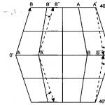
An important consequence of the axial rotation of the Earth is the deflection of bodies moving in a horizontal plane (winds, rivers, sea currents, etc.). from their original direction: in the northern hemisphere - right, in the southern to the left(this is one of the forces of inertia, named Coriolis acceleration in honor of the French scientist who first explained this phenomenon). According to the law of inertia, each moving body strives to keep the direction and speed of its movement in the world space unchanged (Fig. 17). Deviation is the result of the fact that the body participates simultaneously in both translational and rotational movements. At the equator, where the meridians are parallel to each other, their direction in world space does not change during rotation and the deviation is zero. Towards the poles, the deviation increases and becomes greatest at the poles, since there each meridian changes its direction in space by 360 ° per day. The Coriolis force is calculated by the formula F = m x 2ω x υ x sin φ, where F is the Coriolis force, T is the mass of the moving body, ω is the angular velocity, υ is the speed of the moving body, φ is the geographic latitude. The manifestation of the Coriolis force in natural processes is very diverse. It is because of it that vortices of various scales arise in the atmosphere, including cyclones and anticyclones, winds and sea currents deviate from the gradient direction, influencing the climate and through it the natural zonality and regionality; the asymmetry of large river valleys is associated with it: in the northern hemisphere, many rivers (Dnepr, Volga, etc.) for this reason, the right banks are steep, the left ones are gentle, and vice versa in the southern hemisphere.
The rotation of the Earth is associated with a natural unit of time measurement - day and going on the change of night and day. Days are stellar and sunny. sidereal day is the time interval between two successive upper culminations of the star through the meridian of the observation point. During a sidereal day, the Earth makes a complete revolution around its axis. They are equal to 23 hours 56 minutes 4 seconds. Sidereal days are used in astronomical observations. true solar day- the time interval between two successive upper culminations of the center of the Sun through the meridian of the observation point. The duration of a true solar day varies throughout the year, primarily due to the uneven movement of the Earth in an elliptical orbit. Hence, they are also inconvenient for measuring time. For practical purposes, they use average solar days. Mean solar time is measured by the so-called mean Sun - an imaginary point that moves uniformly along the ecliptic and makes a complete revolution per year, like the true Sun. The average solar day is 24 hours. They are longer than stellar ones, since the Earth rotates around its axis in the same direction in which it orbits around the Sun with an angular velocity of about 1 ° per day. Because of this, the Sun moves against the background of the stars, and the Earth still needs to “turn around” by about 1 ° so that the Sun “comes” to the same meridian. Thus, in a solar day, the Earth rotates approximately 361 °. To convert true solar time to mean solar time, an amendment is introduced - the so-called time equation. Its maximum positive value is +14 min on February 11, the largest negative value is -16 min on November 3. The beginning of the average solar day is taken as the moment of the lower climax of the average Sun - midnight. This time count is called civil time.
In everyday life, the average solar time is also inconvenient to use, since it is different on each meridian, the local time. For example, on two neighboring meridians drawn at intervals of 1°, the local time differs by 4 minutes. The presence at various points lying on different meridians of their own local time led to many inconveniences. Therefore, at the International Astronomical Congress in 1884, a zone account of time was adopted. To do this, the entire surface of the globe was divided into 24 time zones, 15 ° each. Behind standard time the local time of the middle meridian of each belt is taken. To convert local time to zone time and vice versa, there is a formula T n – m = N – λ °, where T P - standard time, m - the local time, N- the number of hours equal to the number of the belt, λ ° is longitude expressed in hours. The zero (aka 24th) belt is the one in the middle of which the zero (Greenwich) meridian runs. His time is taken as universal time. Knowing universal time, it is easy to calculate standard time using the formula T n = T 0 + N, where T 0 - universal time. The belts are counted to the east. In two neighboring zones, standard time differs by exactly 1 hour. For convenience, time zone boundaries on land are drawn not strictly along meridians, but along natural boundaries (rivers, mountains) or state and administrative borders.
|
|
In our country, standard time was introduced on July 1, 1919. Russia is located in ten time zones: from the second to the eleventh. However, in order to make more rational use of daylight in summer in our country in 1930, a special government decree introduced the so-called maternity time, ahead of the standard time by 1 hour. So, for example, Moscow is formally located in the second time zone, where the standard time is calculated according to the local time of the meridian 30 ° E. But in fact, the time in winter in Moscow is set according to the time of the third time zone, corresponding to the local time on the meridian 45 ° E. e. Such a "relocation" operates throughout Russia, except for the Kaliningrad region, the time in which actually corresponds to the second time zone. |
|
Rice. 17. Deviation of bodies moving along the meridian, in the northern hemisphere - to the right, in the southern hemisphere - to the left |
In a number of countries, the time is moved forward by one hour only for the summer. In Russia, since 1981, for the period from April to October, summer time due to the transfer of time for another hour ahead compared to the maternity. Thus, in summer, the time in Moscow actually corresponds to the local time on the meridian of 60 ° E. e. The time by which residents of Moscow and the second time zone in which it is located live is called Moscow. According to Moscow time in our country, trains and planes are scheduled, the time is marked on telegrams.
In the middle of the twelfth belt, approximately along the 180 ° meridian, in 1884 a international date line. This is a conditional line on the surface of the globe, on both sides of which hours and minutes coincide, and calendar dates differ by one day. For example, on New Year's Eve at 0000 hours, west of this line is already January 1 of the new year, and to the east - only December 31 of the old year. When crossing the border of dates from west to east in the count of calendar days, they return one day ago, and from east to west one day is skipped in the count of dates.
The change of day and night creates daily rhythm in living and inanimate nature. The daily rhythm is associated with light and temperature conditions. The daily course of temperature, day and night breezes, etc., are well known. The daily rhythm of living nature is very clearly manifested. It is known that photosynthesis is possible only during the day, in the presence of sunlight, that many plants open their flowers at different hours. According to the time of manifestation of activity, animals can be divided into nocturnal and diurnal: most of them are awake during the day, but many (owls, bats, night butterflies) are in the darkness of the night. Human life also proceeds in a daily rhythm.
 Rice. 18. Twilight and white nights
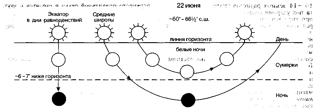
The period of smooth transition from daylight to night darkness and back is called twilight. IN they are based on an optical phenomenon observed in the atmosphere before sunrise and after sunset, when it is still (or already) under the horizon line, but illuminates the sky, from which light is reflected. The duration of twilight depends on the declination of the Sun (the angular distance of the Sun from the plane of the celestial equator) and the geographical latitude of the place of observation. At the equator, twilight is short, increasing with latitude. There are three periods of twilight. Civil twilight are observed when the center of the Sun plunges below the horizon shallowly (at an angle of up to 6 °) and for a short time. This is actually White Nights, when the evening dawn converges with the morning dawn. In summer they are observed at latitudes of 60° or more. For example / in St. Petersburg (latitude 59 ° 56 "N) they last from June 11 to July 2, in Arkhangelsk (64 ° 33" N) - from May 13 to July 30. Navigational twilight are observed when the center of the solar disk plunges below the horizon by 6–12°. At the same time, the horizon line is visible, and from the ship it is possible to determine the angle of the stars above it. And finally astronomical twilight are observed when the center of the solar disk submerges below the horizon by 12–18°. At the same time, the dawn in the sky still prevents astronomical observations of faint stars (Fig. 18).
The rotation of the Earth gives two fixed points - geographic poles(points of intersection of the imaginary axis of rotation of the Earth with the earth's surface) - and thus allows you to build a grid of parallels and meridians. Equator(lat. aequator - equalizer) - the line of intersection of the globe with a plane passing through the center of the Earth perpendicular to the axis of its rotation. Parallels(gr. parallelos - going side by side) - the lines of intersection of the earth's ellipsoid by planes parallel to the plane of the equator. meridians(lat. meridlanus - midday) - the lines of intersection of the earth's ellipsoid by planes passing through both of its poles. The length of 1° meridian is on average 111.1 km.