The position of the earth's crust between the mantle and the outer shells - the atmosphere, hydrosphere and biosphere - determines the impact on it of the external and internal forces of the Earth.
The structure of the earth's crust is heterogeneous (Fig. 19). The upper layer, whose thickness varies from 0 to 20 km, is complex sedimentary rocks- sand, clay, limestone, etc. This is confirmed by the data obtained from the study of outcrops and cores of boreholes, as well as the results of seismic studies: these rocks are loose, the speed of seismic waves is low.
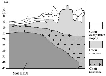
Rice. 19. The structure of the earth's crust
Below, under the continents, is located granite layer, composed of rocks, the density of which corresponds to the density of granite. The velocity of seismic waves in this layer, as in granites, is 5.5–6 km/s.
Under the oceans, the granite layer is absent, and on the continents in some places it comes to the surface.
Even lower is the layer in which seismic waves propagate at a speed of 6.5 km/s. This speed is typical for basalts, therefore, despite the fact that the layer is composed of different rocks, it is called basalt.
The boundary between the granite and basalt layers is called Conrad surface. This section corresponds to a seismic wave velocity jump from 6 to 6.5 km/s.
Depending on the structure and thickness, two types of bark are distinguished - mainland and oceanic. Under the continents, the crust contains all three layers - sedimentary, granite and basalt. Its thickness on the plains reaches 15 km, and in the mountains it increases to 80 km, forming the "roots of the mountains". Beneath the oceans, the granitic layer in many places is completely absent, and the basalts are covered with a thin cover of sedimentary rocks. In the deep parts of the ocean, the thickness of the crust does not exceed 3–5 km, and the upper mantle lies below.
Mantle. This is an intermediate shell located between the lithosphere and the Earth's core. Its lower boundary passes presumably at a depth of 2900 km. The mantle accounts for more than half of the Earth's volume. The substance of the mantle is in an overheated state and is under enormous pressure from the overlying lithosphere. The mantle has a great influence on the processes occurring on the Earth. In the upper mantle, magma chambers arise, ores, diamonds and other fossils are formed. From here, internal heat comes to the surface of the Earth. The substance of the upper mantle is constantly and actively moving, causing the movement of the lithosphere and the earth's crust.
Nucleus. Two parts are distinguished in the core: the outer, to a depth of 5 thousand km, and the inner, to the center of the Earth. The outer core is liquid, since transverse waves do not pass through it, the inner core is solid. The substance of the core, especially the inner one, is highly compacted and corresponds in density to metals, which is why it is called metallic.
§ 17. Physical properties and chemical composition of the Earth
The physical properties of the Earth include temperature (internal heat), density and pressure.
Internal heat of the Earth. According to modern concepts, the Earth after its formation was a cold body. Then the decay of radioactive elements gradually warmed it up. However, as a result of heat radiation from the surface to near-Earth space, it cooled. A relatively cold lithosphere and the earth's crust formed. At great depths and today high temperatures. An increase in temperature with depth can be observed directly in deep mines and boreholes, during volcanic eruptions. Thus, erupting volcanic lava has a temperature of 1200–1300 °C.
On the surface of the Earth, the temperature is constantly changing and depends on the influx of solar heat. Daily temperature fluctuations extend to a depth of 1–1.5 m, seasonal fluctuations - up to 30 m. Below this layer lies a zone of constant temperatures, where they always remain unchanged and correspond to the average annual temperatures of a given area on the Earth's surface.
The depth of the zone of constant temperatures in different places is not the same and depends on the climate and the thermal conductivity of the rocks. Below this zone, temperatures begin to rise, on average by 30 ° C every 100 m. However, this value is not constant and depends on the composition of rocks, the presence of volcanoes, and the activity of thermal radiation from the bowels of the Earth. So, in Russia it ranges from 1.4 m in Pyatigorsk to 180 m on the Kola Peninsula.
Knowing the radius of the Earth, we can calculate that in the center of its temperature should reach 200,000 ° C. However, at this temperature, the Earth would turn into a hot gas. It is generally accepted that a gradual increase in temperature occurs only in the lithosphere, and the upper mantle serves as the source of the Earth's internal heat. Below, the rise in temperature slows down, and in the center of the Earth it does not exceed 50,000 °C.
Density of the Earth. The denser the body, the greater the mass per unit volume. The density standard is considered to be water, 1 cm 3 of which weighs 1 g, i.e. the density of water is 1 g / s 3. The density of other bodies is determined by the ratio of their mass to the mass of water of the same volume. From this it is clear that all bodies with a density greater than 1 sink, less - float.
The density of the Earth varies from place to place. Sedimentary rocks have a density of 1.5–2 g/cm3, while basalts have a density of more than 2 g/cm3. The average density of the Earth is 5.52 g / cm 3 - this is more than 2 times the density of granite. In the center of the Earth, the density of its constituent rocks increases and amounts to 15–17 g/cm 3 .
pressure inside the earth. Rocks located in the center of the Earth experience tremendous pressure from the overlying layers. It is calculated that at a depth of only 1 km the pressure is 10 4 hPa, while in the upper mantle it exceeds 6 * 10 4 hPa. Laboratory experiments show that under such pressure, solids, such as marble, bend and can even flow, that is, they acquire properties intermediate between a solid and a liquid. This state of matter is called plastic. This experiment allows us to state that in the deep bowels of the Earth, matter is in a plastic state.
The chemical composition of the Earth. In the Earth you can find all the chemical elements of the table of D. I. Mendeleev. However, their number is not the same, they are distributed extremely unevenly. For example, in the earth's crust, oxygen (O) is more than 50%, iron (Fe) is less than 5% of its mass. It is estimated that the basalt and granite layers consist mainly of oxygen, silicon and aluminum, while the proportion of silicon, magnesium and iron increases in the mantle. In general, it is considered that 8 elements (oxygen, silicon, aluminum, iron, calcium, magnesium, sodium, hydrogen) account for 99.5% of the composition of the earth's crust, and all the rest - 0.5%. The data on the composition of the mantle and the core are speculative.
§ 18. Movement of the earth's crust
The earth's crust only seems to be motionless, absolutely stable. In fact, it performs continuous and varied movements. Some of them occur very slowly and are not perceived by the human senses, others, such as earthquakes, are landslide, destructive. What titanic forces move the earth's crust?
The internal forces of the Earth, the source of their origin. It is known that at the boundary between the mantle and the lithosphere, the temperature exceeds 1500 °C. At this temperature, matter must either melt or turn into a gas. When solids pass into a liquid or gaseous state, their volume should increase. However, this does not happen, since the overheated rocks are under pressure from the overlying layers of the lithosphere. There is a "steam boiler" effect, when matter tending to expand puts pressure on the lithosphere, setting it in motion together with the earth's crust. Moreover, the higher the temperature, the stronger the pressure and the more actively the lithosphere moves. Particularly strong pressure centers arise in those places of the upper mantle where radioactive elements are concentrated, the decay of which heats the constituent rocks to even higher temperatures. The movements of the earth's crust under the influence of the internal forces of the Earth are called tectonic. These movements are divided into oscillatory, folding and discontinuous.
oscillatory movements. These movements occur very slowly, imperceptibly to humans, which is why they are also called century old or epeirogenic. In some places the earth's crust is rising, in others it is falling. In this case, the uplift is often replaced by a lowering, and vice versa. These movements can be traced only by those "traces" that remain after them on the earth's surface. For example, on the Mediterranean coast, near Naples, there are the ruins of the temple of Serapis, the columns of which are excavated by sea mollusks at a height of up to 5.5 m above the level of the modern sea. This serves as unconditional proof that the temple, built in the 4th century, was at the bottom of the sea, and then it was raised. Now this piece of land is sinking again. Often on the coasts of the seas above their modern level there are steps - sea terraces, once created by the sea surf. On the platforms of these steps, you can find the remains of marine organisms. This indicates that the platforms of the terraces were once the bottom of the sea, and then the coast rose and the sea receded.
The lowering of the earth's crust below 0 m above sea level is accompanied by the onset of the sea - transgression and the rise - its retreat - regression. At present, in Europe, uplifts occur in Iceland, Greenland, and the Scandinavian Peninsula. Observations have established that the region of the Gulf of Bothnia is rising at a rate of 2 cm per year, i.e., 2 m per century. At the same time, the territory of Holland, southern England, northern Italy, the Black Sea lowland, and the coast of the Kara Sea are sinking. A sign of the lowering of the sea coasts is the formation of sea bays in the mouth sections of rivers - estuaries (lips) and estuaries.
With the rise of the earth's crust and the retreat of the sea, the seabed, composed of sedimentary rocks, turns out to be land. Thus, extensive marine (primary) plains: for example, West Siberian, Turan, North Siberian, Amazonian (Fig. 20).
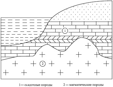
Rice. twenty. The structure of primary, or marine, stratal plains
Folding movements. In cases where rock layers are sufficiently plastic, under the action of internal forces, they are crushed into folds. When the pressure is directed vertically, the rocks are displaced, and if in a horizontal plane, they are compressed into folds. The shape of the folds is the most diverse. When the bend of the fold is directed downward, it is called a syncline, upward - an anticline (Fig. 21). Folds are formed at great depths, that is, at high temperatures and high pressure, and then, under the action of internal forces, they can be raised. This is how folded mountains Caucasian, Alps, Himalayas, Andes, etc. (Fig. 22). In such mountains, folds are easy to observe where they are exposed and come to the surface.
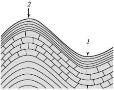
Rice. 21. Synclinal (1) and anticlinal (2) folds
Rice. 22. Fold mountains
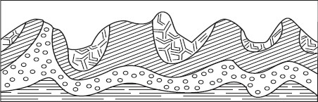
Breaking movements. If the rocks are not strong enough to withstand the action of internal forces, cracks form in the earth's crust - faults and a vertical displacement of the rocks occurs. The sunken areas are called grabens, and those who have risen handfuls(Fig. 23). The alternation of horsts and grabens creates blocky (resurrected) mountains. Examples of such mountains are: Altai, Sayan, Verkhoyansk Range, Appalachians in North America and many others. The revived mountains differ from the folded ones both in their internal structure and in their appearance - morphology. The slopes of these mountains are often steep, the valleys, like the watersheds, are wide and flat. Rock layers are always displaced relative to each other.
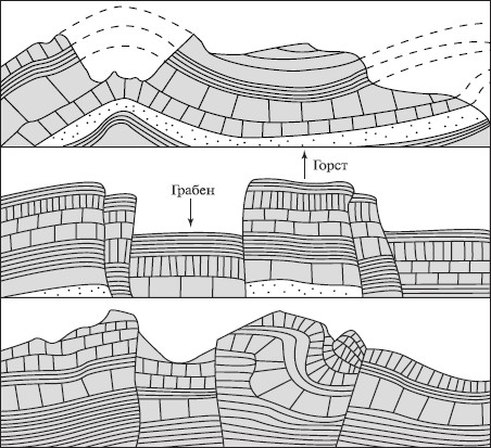
Rice. 23. Restored fold-block mountains
The sunken areas in these mountains, the grabens, are sometimes filled with water, and then deep lakes are formed: for example, Baikal and Teletskoye in Russia, Tanganyika and Nyasa in Africa.
§ 19. Volcanoes and earthquakes
With a further increase in temperature in the bowels of the Earth, rocks, despite high pressure, melt, forming magma. This releases a lot of gases. This further increases both the volume of the melt and its pressure on the surrounding rocks. As a result, very dense, gas-rich magma tends to where the pressure is less. It fills cracks in the earth's crust, breaks and lifts the layers of its constituent rocks. Part of the magma, not reaching the earth's surface, solidifies in the thickness of the earth's crust, forming magmatic veins and laccoliths. Sometimes magma breaks out to the surface, and it erupts in the form of lava, gases, volcanic ash, rock fragments and hardened lava clots.
Volcanoes. Each volcano has a channel through which lava erupts (Fig. 24). it vent, which always ends in a funnel-shaped expansion - crater. The diameter of the craters ranges from several hundred meters to many kilometers. For example, the diameter of the Vesuvius crater is 568 m. Very large craters are called calderas. For example, the caldera of the Uzona volcano in Kamchatka, which is filled by Lake Kronotskoye, reaches 30 km in diameter.
The shape and height of volcanoes depend on the viscosity of the lava. Liquid lava spreads quickly and easily and does not form cone-shaped mountains. An example is the Kilauza volcano in the Hawaiian Islands. The crater of this volcano is a rounded lake with a diameter of about 1 km, filled with bubbling liquid lava. The level of lava, like water in a spring bowl, then falls, then rises, splashing over the edge of the crater.
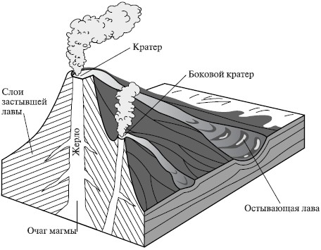
Rice. 24. Sectional volcanic cone
Volcanoes with viscous lava are more widespread, which, when cooled, form a volcanic cone. The cone always has a layered structure, which indicates that the outpourings occurred repeatedly, and the volcano grew gradually, from eruption to eruption.
The height of volcanic cones varies from several tens of meters to several kilometers. For example, the Aconcagua volcano in the Andes has a height of 6960 m.
There are about 1500 active and extinct mountain volcanoes. Among them are such giants as Elbrus in the Caucasus, Klyuchevskaya Sopka in Kamchatka, Fujiyama in Japan, Kilimanjaro in Africa and many others.
Most of the active volcanoes are located around the Pacific Ocean, forming the Pacific "Ring of Fire", and in the Mediterranean-Indonesian belt. There are 28 active volcanoes known in Kamchatka alone, and there are more than 600 of them in total. Active volcanoes are naturally widespread - all of them are confined to mobile zones of the earth's crust (Fig. 25).
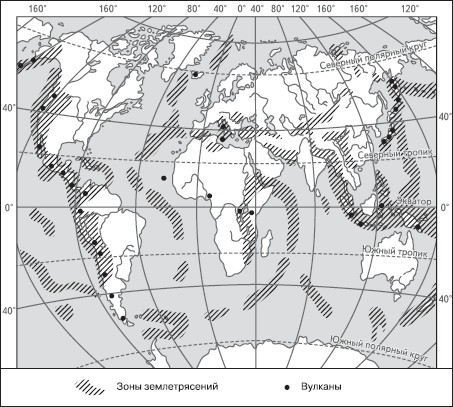
Rice. 25. Zones of volcanism and earthquakes
In the geological past of the Earth, volcanism was more active than it is now. In addition to the usual (central) eruptions, fissure eruptions occurred. From giant cracks (faults) in the earth's crust, stretching for tens and hundreds of kilometers, lava erupted onto the earth's surface. Solid or patchy lava covers were created, leveling the terrain. The lava thickness reached 1.5–2 km. This is how lava plains. Examples of such plains are individual sections of the Central Siberian Plateau, the central part of the Deccan Plateau in India, the Armenian Highlands, and the Columbia Plateau.
Earthquakes. The causes of earthquakes are different: volcanic eruption, landslides in the mountains. But the strongest of them arise as a result of movements of the earth's crust. Such earthquakes are called tectonic. They usually originate at great depths, at the boundary between the mantle and the lithosphere. The origin of an earthquake is called hypocenter or hearth. On the Earth's surface, above the hypocenter, is epicenter earthquakes (Fig. 26). Here, the strength of the earthquake is greatest, and with distance from the epicenter, it weakens.
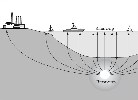
Rice. 26. Hypocenter and epicenter of an earthquake
The earth's crust is constantly shaking. Over 10,000 earthquakes are observed during the year, but most of them are so weak that they are not felt by humans and are recorded only by instruments.
The strength of earthquakes is measured in points - from 1 to 12. Powerful 12-point earthquakes are rare and are catastrophic. During such earthquakes, deformations occur in the earth's crust, cracks, shifts, faults, landslides in the mountains and dips in the plains are formed. If they occur in densely populated areas, then there is great destruction and numerous human casualties. The largest earthquakes in history are the Messinian (1908), Tokyo (1923), Tashkent (1966), Chilean (1976) and Spitak (1988). In each of these earthquakes, dozens, hundreds and thousands of people died, and cities were destroyed almost to the ground.
Often the hypocenter is under the ocean. Then a destructive ocean wave arises - tsunami.
§ 20. External processes that transform the surface of the Earth
Simultaneously with internal, tectonic processes, external processes operate on the Earth. Unlike internal ones, covering the entire thickness of the lithosphere, they act only on the surface of the Earth. The depth of their penetration into the earth's crust does not exceed a few meters, and only in caves - up to several hundred meters. The source of the origin of forces that cause external processes is thermal solar energy.
External processes are very diverse. These include the weathering of rocks, the work of wind, water and glaciers.
Weathering. It is divided into physical, chemical and organic.
physical weathering- this is mechanical crushing, grinding of rocks.
It occurs when there is a sudden change in temperature. When heated, the rock expands; when cooled, it contracts. Since the coefficient of expansion of different minerals included in the rock is not the same, the process of its destruction is enhanced. At first, the rock breaks up into large blocks, which are crushed over time. The accelerated destruction of the rock is facilitated by water, which, penetrating into the cracks, freezes in them, expands and breaks the rock into separate parts. Physical weathering is most active where there is a sharp change in temperature, and solid igneous rocks come to the surface - granite, basalt, syenites, etc.
chemical weathering- this is the chemical effect on rocks of various aqueous solutions.
In this case, unlike physical weathering, various chemical reactions occur, and as a result, a change in the chemical composition and, possibly, the formation of new rocks. Chemical weathering operates everywhere, but it proceeds especially intensively in easily soluble rocks - limestones, gypsum, dolomites.
organic weathering is the process of destruction of rocks by living organisms - plants, animals and bacteria.
Lichens, for example, settling on rocks, wear away their surface with the released acid. Plant roots also secrete acid, and besides, the root system acts mechanically, as if tearing apart the rock. Earthworms, passing inorganic substances through themselves, transform the rock and improve the access of water and air to it.
weathering and climate. All types of weathering occur simultaneously, but act with different intensity. It depends not only on the constituent rocks, but also mainly on the climate.
In polar countries, frosty weathering is most actively manifested, in temperate countries - chemical, in tropical deserts - mechanical, in the humid tropics - chemical.
Wind work. The wind is capable of destroying rocks, carrying and depositing their solid particles. The stronger the wind and the more often it blows, the more work it can do. Where rocky outcrops come to the surface of the Earth, the wind bombards them with grains of sand, gradually erasing and destroying even the hardest rocks. Less resistant rocks are destroyed faster, specific, eolian landforms- stone lace, aeolian mushrooms, pillars, towers.
In sandy deserts and along the shores of seas and large lakes, the wind creates specific landforms - dunes and dunes.
dunes- These are mobile sandy hills of crescent shape. Their windward slope is always gentle (5-10°), and the leeward slope is steep - up to 35–40° (Fig. 27). The formation of dunes is associated with the deceleration of the wind flow carrying sand, which occurs due to any obstacles - surface irregularities, stones, bushes, etc. The wind strength weakens, and sand deposition begins. The more constant the winds and the more sand, the faster the dune grows. The highest dunes - up to 120 m - were found in the deserts of the Arabian Peninsula.
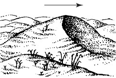
Rice. 27. The structure of the dune (the arrow shows the direction of the wind)
The dunes move in the direction of the wind. The wind drives the grains of sand down a gentle slope. Having reached the ridge, the wind flow swirls, its speed decreases, the grains of sand fall out and roll down the steep leeward slope. This causes the movement of the entire dune at a speed of up to 50–60 m per year. Moving, dunes can fill up oases and even entire villages.
On sandy beaches, the waving sands form dunes. They stretch along the coast in the form of huge sandy ridges or hills up to 100 m or more high. Unlike dunes, they do not have a permanent shape, but can also move inland from the beach. In order to stop the movement of the dunes, trees and shrubs are planted, primarily pines.
The work of snow and ice. Snow, especially in the mountains, does a lot of work. Huge masses of snow accumulate on the slopes of the mountains. From time to time they break down from the slopes, forming snow avalanches. Such avalanches, moving at great speed, capture fragments of rocks and carry them down, sweeping away everything in their path. For the formidable danger posed by snow avalanches, they are called "white death".
The solid material that remains after the snow melts forms huge rocky mounds that block and fill intermountain depressions.
Doing even more work glaciers. They occupy vast areas on Earth - more than 16 million km 2, which is 11% of the land area.
There are continental, or integumentary, and mountain glaciers. continental ice occupy vast areas in Antarctica, Greenland, and on many polar islands. The ice thickness of continental glaciers is not the same. For example, in Antarctica it reaches 4000 m. Under the influence of enormous gravity, the ice slides into the sea, breaks off, and forms icebergs- ice floating mountains.
At mountain glaciers two parts are distinguished - areas of nutrition or accumulation of snow and melting. Snow is accumulating in the mountains above snow line. The height of this line is not the same in different latitudes: the closer to the equator, the higher the snow line. In Greenland, for example, it lies at an altitude of 500-600 m, and on the slopes of the Chimborazo volcano in the Andes - 4800 m.
Above the snow line, snow accumulates, compacts and gradually turns into ice. Ice has plastic properties and under the pressure of the overlying masses begins to slide down the slope. Depending on the mass of the glacier, its saturation with water and the steepness of the slope, the speed of movement varies from 0.1 to 8 m per day.
Moving along the slopes of the mountains, glaciers plow out potholes, smooth out rock ledges, and widen and deepen valleys. The clastic material that the glacier captures during its movement, during the melting (retreat) of the glacier, remains in place, forming a glacial moraine. Moraine- these are piles of fragments of rocks, boulders, sand, clay left by the glacier. There are bottom, lateral, surface, middle and terminal moraines.
Mountain valleys, through which a glacier has ever passed, are easy to distinguish: in these valleys, the remains of moraines are always found, and their shape resembles a trough. Such valleys are called touches.
Work of flowing waters. Flowing waters include temporary rainfall and snowmelt, streams, rivers and groundwater. The work of flowing waters, taking into account the time factor, is grandiose. It can be said that the entire appearance of the earth's surface is to some extent created by flowing water. All flowing waters are united by the fact that they produce three types of work:
– destruction (erosion);
– transfer of products (transit);
– attitude (accumulation).
As a result, various irregularities are formed on the surface of the Earth - ravines, furrows on slopes, cliffs, river valleys, sandy and pebble islands, etc., as well as voids in the thickness of rocks - caves.
The action of gravity. All bodies - liquid, solid, gaseous, located on the Earth - are attracted to it.
The force with which a body is attracted to the earth is called gravity.
Under the influence of this force, all bodies tend to take the lowest position on the earth's surface. As a result, water flows in rivers, rainwater seeps into the thickness of the earth's crust, snow avalanches fall, glaciers move, rock fragments move down the slopes. Gravity is a necessary condition for the action of external processes. Otherwise, the weathering products would have remained at the site of their formation, covering the underlying rocks like a cloak.
§ 21. Minerals and rocks
As you already know, the Earth consists of many chemical elements - oxygen, nitrogen, silicon, iron, etc. When combined, the chemical elements form minerals.
Minerals. Most minerals are made up of two or more chemical elements. You can find out how many elements are contained in a mineral by its chemical formula. For example, halite (table salt) is composed of sodium and chlorine and has the formula NCl; magnetite (magnetic iron ore) - from three molecules of iron and two oxygen (F 3 O 2), etc. Some minerals are formed by one chemical element, for example: sulfur, gold, platinum, diamond, etc. Such minerals are called native. In nature, about 40 native elements are known, which account for 0.1% of the mass of the earth's crust.
Minerals can be not only solid, but also liquid (water, mercury, oil), and gaseous (hydrogen sulfide, carbon dioxide).
Most minerals have a crystalline structure. The shape of the crystal for a given mineral is always constant. For example, quartz crystals have the shape of a prism, halite has the shape of a cube, etc. If table salt is dissolved in water and then crystallized, the newly formed minerals will take on a cubic shape. Many minerals have the ability to grow. Their sizes range from microscopic to gigantic. For example, a beryl crystal 8 m long and 3 m in diameter was found on the island of Madagascar. Its weight is almost 400 tons.
By education, all minerals are divided into several groups. Some of them (feldspar, quartz, mica) are released from magma during its slow cooling at great depths; others (sulphur) - during the rapid cooling of lava; others (garnet, jasper, diamond) - at high temperatures and pressure at great depths; the fourth (garnets, rubies, amethysts) stand out from hot aqueous solutions in underground veins; the fifth (gypsum, salts, brown iron ore) are formed during chemical weathering.
In total, there are more than 2500 minerals in nature. For their definition and study, physical properties are of great importance, which include brilliance, color, color of the line, that is, the trace left by the mineral, transparency, hardness, cleavage, fracture, and specific gravity. For example, quartz has a prismatic crystal shape, glassy luster, no cleavage, conchoidal fracture, hardness 7, specific gravity 2.65 g / cm 3, has no feature; halite has a cubic crystal shape, hardness 2.2, specific gravity 2.1 g / cm 3, glass luster, white color, perfect cleavage, salty taste, etc.
Of the minerals, 40-50 are the most known and widespread, which are called rock-forming (feldspar, quartz, halite, etc.).
Rocks. These rocks are an accumulation of one or more minerals. Marble, limestone, gypsum consist of one mineral, and granite, basalt - from several. In total, there are about 1000 rocks in nature. Depending on the origin - genesis - rocks are divided into three main groups: igneous, sedimentary and metamorphic.
igneous rocks. Formed when magma cools; crystalline structure, do not have layering; do not contain the remains of animals and plants. Among the igneous rocks, deep and erupted are distinguished. deep rocks formed in the depths of the earth's crust, where magma is under high pressure and its cooling is very slow. An example of a deep rock is granite, the most common crystalline rock, consisting mainly of three minerals: quartz, feldspar and mica. The color of granites depends on the color of feldspar. Most often they are gray or pink.
When magma erupts onto the surface, spilled rocks. They represent either a sintered mass resembling slag, or vitreous, then they are called volcanic glass. In some cases, a finely crystalline rock of the basalt type is formed.
Sedimentary rocks. They cover about 80% of the entire surface of the Earth. They are characterized by layering and porosity. As a rule, sedimentary rocks are the result of the accumulation in the seas and oceans of the remains of dead organisms or particles of destroyed hard rocks carried off the land. The accumulation process occurs unevenly, so layers of different thicknesses are formed. Fossils or imprints of animals and plants are found in many sedimentary rocks.
Depending on the place of formation, sedimentary rocks are divided into continental and marine. To continental rocks include, for example, clay. Clays are a crushed product of the destruction of hard rocks. They consist of the smallest scaly particles, have the ability to absorb water. Clays are plastic, waterproof. Their color is different - from white to blue and even black. White clays are used to make porcelain.
Continental origin and widespread rock - loess. It is a fine-grained, non-laminated yellowish rock, consisting of a mixture of quartz, clay particles, lime carbonate and iron oxide hydrates. Easily passes water.
Marine rocks usually formed at the bottom of the oceans. These include some clays, sands, gravel.
Large group of sedimentary biogenic rocks formed from the remains of dead animals and plants. These include limestone, dolomite and some combustible minerals (peat, coal, oil shale).
Especially widespread in the earth's crust is limestone, consisting of calcium carbonate. In its fragments one can easily notice accumulations of small shells and even skeletons of small animals. The color of limestones is different, mostly gray.
Chalk is also formed from the smallest shells - the inhabitants of the sea. Huge reserves of this rock are located in the Belgorod region, where along the steep banks of the rivers you can see outcrops of powerful layers of chalk, which stands out for its whiteness.
Limestones, in which there is an admixture of magnesium carbonate, are called dolomites. Limestones are widely used in construction. They are used to produce lime for plastering and cement. The best cement is made from marl.
In those seas where animals with flint shells used to live, and algae containing flint grew, a rock of tripoli was formed. This is a light, dense, usually yellowish or light gray rock, which is a building material.
Sedimentary rocks also include rocks formed by precipitation from aqueous solutions(gypsum, rock salt, potash salt, brown iron ore, etc.).
metamorphic rocks. This group of rocks was formed from sedimentary and igneous rocks under the influence of high temperatures, pressure, and chemical changes. So, under the action of temperature and pressure on clay, clay shales are formed, on sand - dense sandstones, and on limestones - marble. Changes, i.e., metamorphoses, occur not only with sedimentary rocks, but also with igneous ones. Under the influence of high temperatures and pressure, granite acquires a layered structure and a new rock is formed - gneiss.
High temperature and pressure promote recrystallization of rocks. A very strong crystalline rock, quartzite, is formed from sandstones.
§ 22. Development of the earth's crust
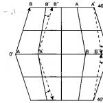
Science has established that more than 2.5 billion years ago, the planet Earth was completely covered by the ocean. Then, under the action of internal forces, the uplift of individual sections of the earth's crust began. The process of uplift was accompanied by violent volcanism, earthquakes, and mountain building. This is how the first land areas appeared - the ancient cores of modern continents. Academician V. A. Obruchev called them "the ancient crown of the Earth."
As soon as the land rose above the ocean, external processes began to operate on its surface. Rocks were destroyed, the destruction products were carried into the ocean and accumulated along its margins in the form of sedimentary rocks. The sediment thickness reached several kilometers, and under its pressure, the ocean floor began to sag. Such giant troughs of the earth's crust under the oceans are called geosynclines. The formation of geosynclines in the history of the Earth has been continuous from ancient times to the present. There are several stages in the life of geosynclines:
– embryonic- deflection of the earth's crust and accumulation of sediments (Fig. 28, A);
– maturation– filling of the trough with sediments when their thickness reaches 15–18 km and radial and lateral pressure arises;
– folding- the formation of folded mountains under the pressure of the internal forces of the Earth (this process is accompanied by violent volcanism and earthquakes) (Fig. 28, B);
– attenuation- destruction of the mountains that have arisen by external processes and the formation of a residual hilly plain in their place (Fig. 28).
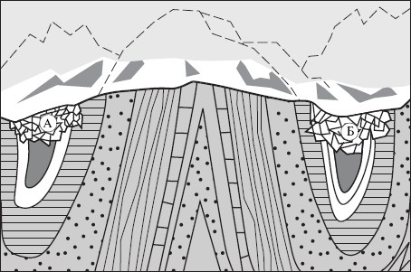
Rice. 28. Scheme of the structure of the plain formed as a result of the destruction of the mountains (the dotted line shows the reconstruction of the former mountainous country)
Since sedimentary rocks in the geosyncline are plastic, as a result of the pressure that has arisen, they are crushed into folds. Folded mountains are formed, such as the Alps, the Caucasus, the Himalayas, the Andes, etc.
The periods when folded mountains are actively formed in geosynclines are called periods of folding. Several such epochs are known in the history of the Earth: Baikal, Caledonian, Hercynian, Mesozoic and Alpine.
The process of mountain building in the geosyncline can also cover the extra-geosynclinal areas - the areas of former, now destroyed mountains. Since the rocks here are rigid, devoid of plasticity, they do not crumple into folds, but are broken by faults. Some areas rise, others fall - there are revived blocky and folded-blocky mountains. For example, in the Alpine era of folding, the folded Pamir mountains were formed and the Altai and Sayan mountains were revived. Therefore, the age of mountains is determined not by the time of their formation, but by the age of the folded base, which is always indicated on tectonic maps.
Geosynclines at different stages of development still exist today. So, along the Asian coast of the Pacific Ocean, in the Mediterranean Sea, there is a modern geosyncline, which is undergoing a stage of maturation, and in the Caucasus, in the Andes and other folded mountains, the process of mountain building is being completed; The Kazakh upland is a peneplain, a hilly plain formed on the site of the destroyed mountains of the Caledonian and Hercynian folding. The base of ancient mountains comes to the surface here - small hills - "witness mountains", composed of strong igneous and metamorphic rocks.
Vast areas of the earth's crust, with relatively low mobility and flat terrain, are called platforms. At the base of the platforms, in their foundation, there are strong igneous and metamorphic rocks, which testify to mountain building processes that once took place here. Usually the foundation is covered with a layer of sedimentary rocks. Sometimes the basement rocks come to the surface, forming shields. The age of the platform corresponds to the age of the foundation. The ancient (Precambrian) platforms include the East European, Siberian, Brazilian, etc.
Platforms are mostly plains. They experience predominantly oscillatory movements. However, in some cases, the formation of revived blocky mountains is also possible on them. Thus, as a result of the emergence of the Great African Rifts, individual sections of the ancient African platform were raised and lowered and blocky mountains and highlands of East Africa, the volcano mountains of Kenya and Kilimanjaro were formed.
Lithospheric plates and their movement. The doctrine of geosynclines and platforms has received a name in science "fixism" because according to this theory, large blocks of the crust are fixed in one place. In the second half of the XX century. many scholars supported theory of mobilism which is based on the concept of horizontal movements of the lithosphere. According to this theory, the entire lithosphere is divided by deep faults reaching the upper mantle into giant blocks - lithospheric plates. The boundaries between plates can pass both on land and on the bottom of the oceans. In the oceans, these boundaries are usually mid-ocean ridges. In these areas, a large number of faults have been recorded - rifts, along which the substance of the upper mantle pours out to the ocean floor, spreading over it. In those areas where the boundaries between the plates pass, mountain building processes are often activated - in the Himalayas, Andes, Cordillera, Alps, etc. The base of the plates is in the asthenosphere, and along its plastic substrate, lithospheric plates, like giant icebergs, slowly move in different directions (Fig. 29). The movement of the plates is fixed by the most accurate measurements from space. Thus, the African and Arabian coasts of the Red Sea are slowly moving away from each other, which allowed some scientists to call this sea the "embryo" of the future ocean. Space images also make it possible to trace the direction of deep faults in the earth's crust.
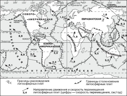
Rice. 29. Movement of lithospheric plates
The theory of mobilism convincingly explains the formation of mountains, since their formation requires not only radial, but also lateral pressure. Where two plates collide, one of them sinks under the other, and “hummocks”, i.e. mountains, form along the collision boundary. This process is accompanied by earthquakes and volcanism.
§ 23. The relief of the globe
Relief- this is a set of irregularities of the earth's surface, differing in height above sea level, origin, etc.
These irregularities give a unique appearance to our planet. The formation of the relief is influenced by both internal, tectonic, and external forces. Due to tectonic processes, mainly large surface irregularities arise - mountains, highlands, etc., and external forces are aimed at their destruction and the creation of smaller relief forms - river valleys, ravines, dunes, etc.
All forms of relief are divided into concave (hollows, river valleys, ravines, beams, etc.), convex (hills, mountain ranges, volcanic cones, etc.), simply horizontal and inclined surfaces. Their size can be very diverse - from a few tens of centimeters to many hundreds and even thousands of kilometers.
Depending on the scale, planetary, macro-, meso- and micro-forms of relief are distinguished.
The planetary ones include the protrusions of the continents and the depressions of the oceans. Continents and oceans are often antipodes. Thus, Antarctica lies against the Arctic Ocean, North America against the Indian Ocean, Australia against the Atlantic, and only South America against Southeast Asia.
The depths of oceanic trenches fluctuate widely. The average depth is 3800 m, and the maximum, noted in the Mariana Trench of the Pacific Ocean, is 11,022 m. The highest land point, Mount Everest (Chomolungma), reaches 8848 m. Thus, the height amplitude reaches almost 20 km.
The prevailing depths in the ocean are from 3000 to 6000 m, and the heights on land are less than 1000 m. High mountains and deep-sea depressions cover only fractions of a percent of the Earth's surface.
The average height of the continents and their parts above sea level is also not the same: North America - 700 m, Africa - 640, South America - 580, Australia - 350, Antarctica - 2300, Eurasia - 635 m, and the height of Asia is 950 m, and Europe is only 320 m. Average land height 875 m.
Relief of the ocean floor. At the bottom of the ocean, as well as on land, there are various landforms - mountains, plains, depressions, trenches, etc. They usually have softer outlines than similar landforms, since external processes proceed more calmly here.
In the relief of the ocean floor, there are:
– continental shelf, or shelf (shelf), - a shallow part up to a depth of 200 m, the width of which in some cases reaches many hundreds of kilometers;
– continental slope– rather steep ledge up to a depth of 2500 m;
– ocean bed, which occupies most of the bottom with depths up to 6000 m.
The greatest depths are noted in gutters, or ocean trenches, where they exceed the mark of 6000 m. The trenches usually stretch along the continents along the outskirts of the ocean.
In the central parts of the oceans, there are mid-ocean ridges (rifts): South Atlantic, Australian, Antarctic, etc.
Sushi relief. The main elements of land relief are mountains and plains. They form the macrorelief of the Earth.
mountain they call a hill that has a peak point, slopes, sole line, rising above the terrain above 200 m; an elevation up to 200 m high is called hill. Linearly elongated landforms with a ridge and slopes are mountain ranges. The ridges are separated by located between them mountain valleys. Connecting with each other, mountain ranges form mountain ranges. The collection of ridges, chains and valleys is called mountain node, or mountain country, and in everyday life mountains. For example, the Altai Mountains, the Ural Mountains, etc.
Extensive areas of the earth's surface, consisting of mountain ranges, valleys and high plains, are called highlands. For example, the Iranian Highlands, the Armenian Highlands, etc.
By origin, mountains are tectonic, volcanic and erosional.
tectonic mountains formed as a result of movements of the earth's crust, they consist of one or many folds raised to a considerable height. All the highest mountains in the world - the Himalayas, the Hindu Kush, the Pamirs, the Cordillera, etc. - are folded. They are characterized by pointed peaks, narrow valleys (gorges), elongated ridges.
blocky and fold-block mountains are formed as a result of raising and lowering blocks (blocks) of the earth's crust along the fault planes. The relief of these mountains is characterized by flat tops and watersheds, wide, flat-bottomed valleys. These are, for example, the Ural Mountains, Appalachians, Altai, etc.
volcanic mountains formed as a result of the accumulation of products of volcanic activity.
Widespread on the surface of the earth erosion mountains, which are formed as a result of the dismemberment of high plains by external forces, primarily flowing waters.
According to the height, the mountains are divided into low (up to 1000 m), medium-high (from 1000 to 2000 m), high (from 2000 to 5000 m) and highest (above 5 km).
The height of the mountains is easy to determine on a physical map. It can also be used to determine that most of the mountains are medium-high and high. Few peaks rise above 7000 m, and they are all in Asia. Only 12 mountain peaks located in the Karakorum mountains and the Himalayas have a height of more than 8000 m. The highest point of the planet is the mountain, or, more precisely, the mountain junction, Everest (Chomolungma) - 8848 m.
Most of the land surface is occupied by flat spaces. Plains- These are areas of the earth's surface that have a flat or slightly hilly relief. Most often, the plains are slightly sloping.
According to the nature of the surface, the plains are divided into flat, wavy and hilly, but on vast plains, such as Turan or West Siberian, one can meet areas with various forms of surface topography.
Depending on the height above sea level, the plains are divided into base(up to 200 m), sublime(up to 500 m) and high (plateaus)(over 500 m). Elevated and high plains are always strongly dissected by water flows and have a hilly relief, while lowlands are often flat. Some plains are located below sea level. So, the Caspian lowland has a height of 28 m. Quite often on the plains there are closed basins of great depth. For example, the Karagis depression has a mark of 132 m, and the Dead Sea depression - 400 m.
Elevated plains bounded by steep ledges separating them from the surrounding area are called plateau. Such are the Ustyurt, Putorana and other plateaus.
Plateau- flat-topped areas of the earth's surface, can have a significant height. So, for example, the Tibet plateau rises above 5000 m.
By origin, several types of plains are distinguished. Significant areas of land are occupied marine (primary) plains, formed as a result of marine regressions. These are, for example, the Turan, West Siberian, Great Chinese and a number of other plains. Almost all of them belong to the great plains of the planet. Most of them are lowlands, the relief is flat or slightly hilly.
Reservoir plains- These are flat sections of ancient platforms with almost horizontal occurrence of sedimentary rock layers. Such plains include, for example, East European. These plains are mostly hilly.
Small spaces in river valleys are occupied alluvial (alluvial) plains, formed as a result of leveling the surface with river sediments - alluvium. This type includes the Indo-Gangetic, Mesopotamian, and Labrador plains. These plains are low, flat, and very fertile.
Plains are raised high above sea level - lava sheets(Central Siberian Plateau, Ethiopian and Iranian Highlands, Deccan Plateau). Some plains, such as the Kazakh uplands, were formed as a result of the destruction of mountains. They are called erosional. These plains are always elevated and hilly. These hills are composed of solid crystalline rocks and represent the remains of the mountains that once were here, their "roots".
§ 24. Soil
The soil- this is the upper fertile layer of the lithosphere, which has a number of properties inherent in living and inanimate nature.
The formation and existence of this natural body cannot be imagined without living beings. The surface layers of the rock are only the initial substrate, from which various types of soils are formed under the influence of plants, microorganisms and animals.
The founder of soil science, the Russian scientist V.V. Dokuchaev, showed that
the soil- this is an independent natural body formed on the surface of rocks under the influence of living organisms, climate, water, relief, as well as man.
This natural formation has been created for thousands of years. The process of soil formation begins with a settlement on bare rocks, stones of microorganisms. Feeding on carbon dioxide, nitrogen and water vapor from the atmosphere, using the mineral salts of the rock, microorganisms release organic acids as a result of their vital activity. These substances gradually change the chemical composition of rocks, make them less durable and eventually loosen the surface layer. Then lichens settle on such a rock. Unpretentious to water and nutrients, they continue the process of destruction, while enriching the rock with organic matter. As a result of the activity of microorganisms and lichens, the rock gradually turns into a substrate suitable for colonization by plants and animals. The final transformation of the original rock into soil occurs due to the vital activity of these organisms.
Plants, absorbing carbon dioxide from the atmosphere, and water and minerals from the soil, create organic compounds. When dying, plants enrich the soil with these compounds. Animals feed on plants and their remains. Their waste products are excrement, and after death, their corpses also fall into the soil. The entire mass of dead organic matter accumulated as a result of the vital activity of plants and animals serves as a food base and habitat for microorganisms and fungi. They destruct organic substances, mineralize them. As a result of the activity of microorganisms, complex organic substances are formed that make up the humus of the soil.
soil humus is a mixture of stable organic compounds formed during the decomposition of plant and animal residues and their metabolic products with the participation of microorganisms.
The breakdown of primary minerals and the formation of clay secondary minerals occur in the soil. Thus, the circulation of substances takes place in the soil.
moisture capacity is the ability of the soil to hold water.
Soil with a lot of sand does not retain water well and has a low water capacity. Clay soil, on the other hand, retains a lot of water and has a high water capacity. In the case of heavy rainfall, water fills all the pores in such soil, preventing the passage of air deep into. Loose, cloddy soils retain moisture better than dense ones.
moisture permeability is the ability of the soil to pass water.
The soil is permeated with tiny pores - capillaries. Through the capillaries, water can move not only down, but also in all directions, including from bottom to top. The higher the capillarity of the soil, the higher its moisture permeability, the faster the water penetrates the soil and rises from the deeper layers upwards. Water "sticks" to the walls of the capillaries and, as it were, creeps up. The thinner the capillaries, the higher the water rises through them. When the capillaries come to the surface, the water evaporates. Sandy soils are highly permeable, while clay soils are low. If a crust (with many capillaries) has formed on the surface of the soil after rain or watering, the water evaporates very quickly. When loosening the soil, the capillaries are destroyed, which reduces the evaporation of water. No wonder loosening the soil is called dry irrigation.
Soils can have a different structure, i.e., consist of lumps of various shapes and sizes, into which soil particles are glued. In the best soils, such as chernozems, the structure is finely cloddy or granular. According to the chemical composition of the soil can be rich or poor in nutrients. An indicator of soil fertility is the amount of humus, since it contains all the main plant nutrients. So, for example, chernozem soils contain up to 30% of humus. Soils can be acidic, neutral or alkaline. Neutral soils are the most favorable for plants. To reduce acidity, they are limed, and gypsum is added to the soil to reduce alkalinity.
Mechanical composition of soils. According to the mechanical composition of the soil are divided into clay, sandy, loamy and sandy loamy.
Clay soils have a high moisture capacity and are best provided with batteries.
sandy soils low moisture capacity, well moisture permeable, but poor in humus.
loamy- the most favorable in terms of their physical properties for agriculture, with an average moisture capacity and moisture permeability, well provided with humus.
sandy loam– structureless soils, poor in humus, well water- and air-permeable. To use such soils, it is necessary to improve their composition, to apply fertilizers.
Soil types. In our country, the following types of soils are most common: tundra, podzolic, sod-podzolic, chernozem, chestnut, gray earth, red earth and yellow earth.
tundra soils are located in the Far North in the permafrost zone. They are waterlogged and extremely poor in humus.
Podzolic soils common in the taiga under conifers, and sod-podzolic- under coniferous-deciduous forests. Broad-leaved forests grow on gray forest soils. All these soils contain enough humus and are well structured.
In the forest-steppe and steppe zones are located black earth soils. They were formed under the steppe and herbaceous vegetation, rich in humus. The humus gives the soil a black color. They have a strong structure and have high fertility.
chestnut soils located further south, they form in drier conditions. They are characterized by a lack of moisture.
Serozem soils characteristic of deserts and semi-deserts. They are rich in nutrients, but poor in nitrogen, and there is not enough water here.
Krasnozems and zheltozems are formed in the subtropics in a humid and warm climate. They are well structured, quite water-intensive, but have a lower humus content, so fertilizers are applied to these soils to increase fertility.
To improve soil fertility, it is necessary to regulate in them not only the content of nutrients, but also the presence of moisture and aeration. The arable layer of the soil should always be loose to ensure air access to the roots of plants.
Consolidated cargo: cargo transportation from Moscow trucking goods marstrans.ru.